Highway shield

Last updated
The shields for Interstate highways (left) and U.S. routes (right) can be seen on this set of reassurance markers in Southwest Virginia indicating two sets of wrong-way concurrencies NB77SB81.JPG
The shields for Interstate highways (left) and U.S. routes (right) can be seen on this set of reassurance markers in Southwest Virginia indicating two sets of wrong-way concurrencies

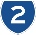
A highway shield or route marker is a sign denoting the route number of a highway, usually in the form of a symbolic shape with the route number enclosed. As the focus of the sign, the route number is usually the sign's largest element, with other items on the sign rendered in smaller sizes or contrasting colors. Highway shields are used by travellers, commuters, and all levels of government for identifying, navigating, and organising routes within a given jurisdiction. Simplified highway shields often appear on maps.

Contents

Purposes

The advance sign for the junction with the highway 4 (E8/E75) on the highway 20 in Oulu, Finland, looking east. Valtatie 20 Finland Oulu Valivainio sign 20080524.jpg
The advance sign for the junction with the highway 4 (E8/E75) on the highway 20 in Oulu, Finland, looking east.

There are several distinct uses for the highway shield:

Comparison table

International (style may vary according to local country):

National:

Controlled-access highway Primary route (usually called National/Federal Highway/Route)Other routes (usually called Regional/County/etc. Route)
Andorra Not present Schild GC 1 AD.svg Carretera general Schild CS 100 AD.svg Carretera secundaria
Albania Autostrada A1 Albania.svg Autostrada SH1-AL.svg Rruga shtetëtore Rruge te rrethit 37 Albania.svg Rrugë rrethi
Armenia Մ1Հ1
Argentina RN1-AR.svg Ruta nacional RP1-AR.svg Ruta provincial
Austria A1-AT.svg Autobahn S1-AT.svg Schnellstraße

B1-AT.svg Bundesstraße
L1-AT.svg Landesstraße
Azerbaijan AZ-M1.svg Magistrale AZ-R1.svg
Belarus M1-BY.svg Magistrale P1-BY.svg
Belgium BE-A1.svg Autosnelweg BE-N1.svg N-weg
Bolivia Bolivia RF 1.svg Ruta nacional Disco601potosi.png Ruta departemental Ruta municipal 00 plantilla.svg Ruta municipal
Bosnia and Herzegovina A1-BIH.svg Autoput M6-BIH.svg Magistralna cesta
B1-BIH.svg Brze ceste
R400-BIH.svg
Brazil BR-010 jct.svg RJ-014.svg
Bulgaria Mw A1 BG.svg Avtomagistrala Nat road 1 BG.svg Republikanski păt
Cambodia E4-KH.svg N1-KH.svg
Central African Republic Not present Route nationale francaise 1.svg Route nationale Route regionale centrafricaine 1.png Route régionale
Chile Ruta 1 (Chile-1Rb).svg Autopista Ruta 1 (Chile).svg Ruta nacional Ruta A-27 (Chile).svg Ruta regional
China China Expwy G1 sign no name.svg Gāosù Gōnglù Kokudou 101(China).svg Gònghéguó Guódào Shoudou 001(China).svg
Colombia Rutacol-01.svg Ruta nacional
Croatia A1-BIH.svg Autocesta Drzavna cesta D1.svg Državna cesta Z1046-HR.svg Županijska cesta
Cyprus A1 Motorway Cyprus.svg Autokinītodromos B1 road cyprus.svg
Czech Republic CZ traffic sign IS16a - D1.svg Dálnice SilniceI55.svg Silnice
Denmark Using E-road or primary route signs P6-DK.svg Primærrute S150-DK.svg Sekundærrute
Ecuador DISCOE5.png DISCOE28.png Via Colectora
Estonia M1-EE.svg Põhimaantee B12-EE.svg Tugimaantee
Finland Finland road sign F29-1.svg Valtatie Finland road sign F30-42.svg Kantatie Finland road sign F31-522.svg Seututie
France Autoroute francaise 1.svg Autoroute Route nationale francaise 1.svg Route nationale Route departementale francaise 1.svg Route départementale

Route territoriale 10.svg Route territoriale
Georgia S1-GE.svg შ1
Germany Bundesautobahn 1 number.svg Autobahn Bundesstrasse 1 number.svg BundesstraßeL 1Landesstraße

K 1Kreisstraße
Ghana GHA road N1.svg GHA road IR1.png
Greece Autokinetodromos A1 number.svg Avtokinitodromos GR-OEO-2.svg Ethniki Odos
Hungary M1 (Hu) Otszogletu kek tabla.svg Autópálya 1 (Hu) Otszogletu zold tabla.svg Főút
India NE1-IN.svg National expressway NH1-IN.svg National highway Road marker SH IN-GJ 1.svg State highway
Indonesia ID Tol13-5.svg Jalan tol ID Nasional16-17.svg Jalan nasional
Iran IR Freeway 1 sign.svg Azādrāh Iran First Level Road 11.png Bbzrkrah Iran First Level Road 11.png Jadh
Ireland M1-IE.svg Motorway IRL N1.svg National road IRL R123.svg Regional road
Israel ISR-FW-1.svg Kvīsh Arzī Roshī ISR-HW-1.svg Kvīsh Ləʾummī ISR-HW-109.svg Kvīsh Asōrī

ISR-HW-5066.svg Kvīsh Mɘqōmī
Italy Autostrada A1 Italia.svg Autostrada Strada Statale 1 Italia.svg Strada statale Strada Regionale 1 Italia.svg Strada regionale

Strada Provinciale 1 Italia.svg Strada provinciale
Japan JP Expressway E1.svg Kōsokudōro Japanese National Route Sign 0001.svg Kokudō Kyoto Pref Route No.22 Sign.svg Kendō/Fudō/Todō
Jordan JOR Route 5.svg
Kazakhstan M32-KZ.svg

A1-KZ.svg
P1-KZ.svg
Kosovo R6-Kosovo.svg Autostrada M25-Kosovo.svg Magjistralja
Laos Route 1, LAO.png
Latvia A1-LV.svg Autoceļš P1-LV.svg V1-LV.svg
Lithuania A1-LT.svg Automagistralė K101-LT.svg Krašto kelias1Rajoninai kelias
Luxembourg Autoroute 13 (Luxemburg) number.png Autoroute N27 Luxembourg.svg Route nationale
Malaysia Mes-e1.svg Lebuhraya Jkr-ft1.svg Jalan persekutuan
Mexico Carretera federal 1.svg Carretera federal Carretera estatal 1 (Tamaulipas).svg Carretera estatal
Moldova Not present MDA M1.svg Drum public național Schild R1 Moldavie.svg
Montenegro Wegschild Montenegro A-1.svg Autoput Wegschild Montenegro M-18.svg Magistralni put
Namibia Schild A1 NA.svg Schild B1 NA.svg Schild C10 NA.svg
Nepal NPL H01.svg NPL F001.svg
Netherlands NL-A1.png Autosnelweg NLD-N33.svg Autoweg
New Zealand State Highway 1 NZ.svg State highway New Zealand state highway 110 blue shield.png Provincial highway
North Macedonia M1-MKD.svg Avtopat M2-MKD.svg Polaavtopat M101-MKD.svg
Norway Using E-road or primary route signs Norwegian-road-sign-723.13.svg Riksvei Fylkesvei 28.svg Fylkesvei
Pakistan Pakistan M-1.svg N10-PK.png
Paraguay R1-PY.svg
Peru PE-1N route sign.svg LM-110.png
Philippines E1 (Philippines).svg Expressway N9 (Philippines).svg National road
Poland A1-PL.svg Autostrada S1-PL.svg Droga ekspresowa

DK1-PL.svg Droga krajowa
DW142-PL.svg Droga wojewódzka
Portugal A1-PT.svg AutoestradaN 1Estrada nacional
Romania A1-RO.svg Autostradă ROU DN1.svg Drum național DJ100-RO.svg Drum județean
Russia M1-RUS.svg A105-RUS.svg P21-RUS.svg
Serbia Motorway-A1-Hex-Green.svg Autoput M10-SRB.svg Magistralni put M10-SRB.svg Regionalni put
Singapore AYE-SG.svg Expressway
Slovakia D1-SVK-2020.svg Diaľnica R1-SVK-2020.svg Rýchlostná cesta

I11-SVK-2020.svg Cesta
Cesta II. triedy cislo 505.svg Cesta
Slovenia Avtocesta A1.svg Avtocesta Hitra cesta 1.svg Hitra cesta

Glavna cesta 1.svg Glavna cesta
Regionalna cesta 204.svg Regionalna cesta
South Africa SA road N1.svg National route SA road R21.svg
South Korea Korea Expressway No.1.svg Korea National Route No.1.svg
Spain ESP A-1.svg Autovía

ESP AP-1.svg Autopista
ESP N-1.svg Carretera nacional
ESP A-92.svg Carretera principal
C-142.png Carretera comarcal
Sweden Using E-road or primary route signs Riksvag 9.svg Riksväg Vanster - bla.svg 1 - bla.svg 0 - bla.svg 0 - bla.svg Hoger - bla.svg Länsväg
Switzerland A1Swiss.svg Autobahn Hauptstrasse Nummer 1.svg Hauptstraße1Kantonsstraße
Taiwan TWHW1.svg Guódào TW PHW1.svg Shěngdào
Thailand Thai Motorway-t5.svg Thai Motorway-f7.svg Thai Highway-2.svg
Turkey O1-TR sign.svg Otoyol D100-TR.svg Devlet yolu 35-04-TUR.svg İl yolu
Ukraine M01-UA.svg H01-UA.svg P-road-04-Ukraine.svg
Road sign route T-10-01 UA.jpg
United Kingdom UK-Motorway-M1.svg Motorway UK road A1.svg A-road UK road B1440.png B-road
United States I-5.svg Interstate Highway US 1.svg United States Numbered Highway Circle sign 1.svg State Highway/State Road/State Route [lower-alpha 1]
Uruguay R1-UY.svg Ruta nacional
Venezuela Troncal 1 de Venezuela (v3).svg Autopista Local 1 de Anzoategui (I3-4).svg Ruta local
Vietnam CT 01, VNM.svg Cao tốc QL 1, VNM.svg Quốc lộ

Outside the table, some countries also have dedicated shields for municipal-level highways:

Highway shields by country

Australia

Australia has maintained distinctly different trends pertaining to highway shields in the past and will continue in this vein somewhat, despite the conversion to alpha-numeric routes and shields. Alpha-numeric route numbering has been in use in Tasmania since the 1970s, and was introduced in the mainland states from 1996, with the state of Victoria being the first to implement the policy on the mainland.

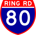
Prior to this conversion and concurrently, Federal Highway (gold-on-green squared-off bullet), National Highway (black-on-white squared-off bullet), State Highway (blue bullet) and Tourist Route (white-on-brown rounded pentagon) shields existed. In Victoria Freeway shields were used (white-on-green with 'F' prefix) until the late 1980s, while during the 1990s Queensland and New South Wales implemented a hexagonal blue-on-white Metroad system of urban arterial routes. The Western Ring Road (now M80) in Melbourne initially used a shield quite similar to the U.S. Interstate shield, albeit with 'Ring Road' written instead of 'Interstate' and with 2 peaks rather than 3.

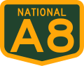
To further complicate matters, with the introduction of the alpha-numeric system, roads that are federally funded (or Federal Highways) have a squared-off bullet encompassing the alpha-numeric designation. Freeways and dual-carriageway roads often use an 'M' prefix, particularly in Victoria. In addition, trapezoidal signs are placed every 5 km on major regional highways and freeways indicating the distance to the post office of the next city or major town on the route. These signs usually only have the first letter of the destination; two or three letters are used if there is ambiguity between nearby towns or when the place name consists of two words.

Australian national route 1.svgAustralian state route 2.svgAustralian national highway 15.svgAUS Alphanumeric Route M1.svgAustralian Tourist Drive 2.svgAUS Metroad 2.svgAUS Alphanumeric Route A1.svgAustralian national highway A8.svgMelbourne freeway F81.svg Australian Ring Road Route 80.png

Brazil

Federal and state highways shields are standardized in Brazil by the National Transit Department (DENATRAN), but implementation is not always consistent nor even existent. In many states, highway names appear on highway location markers and guide signs with no highway shield.

Canada

Each province dictates the type of shields used as highway transportation is a provincial responsibility. However, the green and white signage for the Trans-Canada Highway is used nationwide. Each province has their own shape for the sign, though.

TCH-blank.svg

Alberta

Shields for core highways in Alberta use black route number on a white squared-off bullet, while shields for local highways (500-986) use black route number on a white oval. Both variants feature the provincial wordmark across the top, although it may be omitted on certain guide signs.

Alberta Highway 2.svg Alberta Highway 501.svg

British Columbia

Standard shields for highways in British Columbia use blue route number on a white bullet, with the provincial shield of arms placed at the top. Certain highways (e.g. Crowsnest Highway, Southern Yellowhead Highway and Nisga'a Highway) use their own variations on the default provincial highway shield.

BC-99.svg BC-5 (Yellowhead).svg

Ontario

Major or 400-series highways in Ontario have different kinds of shields depending on usage:

  • Roadside reassurance markers take the shape of a bullet with a crown on top. Default colour scheme is black text on white background, although the Queen Elizabeth Way uses blue "QEW" on gold, and provincially-maintained toll highways (407, 412 and 418) use white route numbers on blue. These shields used to be emblazoned with "The King's Highway" across the top, but the wording has been removed since the 1990s.
  • Markers on guide signs take the shape of a crown silhouette, with the route number placed within.

The exception is the private 407 Express Toll Route, which uses black route number on a white oval marker for both purposes.

Secondary provincial highways use an isosceles trapezoid as markers, while tertiary provincial highway markers use a rectangle with rounded corners.

Numbered roads maintained by Ontario's counties, regional municipalities and single-tier municipalities use an inverted isosceles trapezoid as markers. The default colour scheme is black text on a white background, although certain jurisdictions use their own colour combinations (e.g. white on blue in Niagara, gold on black in Peel, and gold on green in Halton).

On the other hand, instead of an inverted trapezoid, the single-tier city of Toronto uses a roundel for its municipally-maintained freeways, the Gardiner Expressway and the Don Valley Parkway. The design is two-tone gold-on-green, with the road name in white on the green outer ring, and either the cardinal direction (for reassurance markers) or an arrow (for guidance to the freeway) in black on the gold inner disc. The city's other roads, such as Allen Road, do not have their own shields.

Quebec

Shields for controlled-access autoroutes in Quebec use white route number on a blue bullet, with a white stylised drawing of a dual carriageway and an overpass on red across the top. Other provincial routes use white route number on a green French shield with three white fleur-de-lys across the top, while forest routes use white route number on a blue French shield with three white stylised trees across the top.

Quebec Autoroute 5.svg Qc112.svg Quebec R 405.png

Mainland China

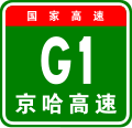
In mainland China, highway shields use specific letter designations to indicate the administrative level of the road, as outlined by the "Highway Route Signage Rules and National Road Numbering" (GB/T 917-2017). The designations are:

For general roads (like general national and provincial roads, county, village, and special-use roads), the shield displays the administrative letter "G(S/X/Y/C/Z)" followed by a three-digit number. National expressways specifically have shields that begin with the letter "G". For main arteries like radial roads from the capital, north-south vertical roads, east-west horizontal roads, and regional ring roads, the shield shows "G" followed by up to two digits. For bypasses, connecting roads, and parallel roads, the shield combines the "G" designation with a two-digit main line number, a type identifier, and a sequence number.

Provincial expressways start with the letter "S". The main arteries and city bypass/connecting road shields display the "S" followed by up to two or two digits, respectively. These provincial expressway shields typically have a yellow background with black characters, showing the province's abbreviation followed by "Expressway", like "Su Expressway" for Jiangsu or "Zhe Expressway" for Zhejiang. In provinces with dense provincial expressway networks, like Guangdong, where S1-S99 cannot cover all roads, shorter connecting roads may use an "S" followed by a four-digit number.

National expressways (国道) feature a red background at the top of their shields, indicating their status as national routes. Provincial expressways (省道) have a yellow background at the top. All other road categories use a white background for their shields.

Germany

German Autobahns as the nation's federal controlled-access highway system use a blue shield with slanted edges and white lettering. Other federal highways use a yellow shield with black lettering. The color schemes mirror the country's directional signage coloring system on these two types of roads.

Autobahn Number Bundesautobahn 38 number.svg
Autobahn Number
Federal Road Number Bundesstrasse 80 number.svg
Federal Road Number

Hong Kong

The Hong Kong Strategic Route and Exit Number System states that the standard shield should consist of a yellow, bullet-shaped shield with the route number in black color. It is used on all numbered routes in Hong Kong.

HK Route4.svg

Japan

The national highways of Japan use a triangular blue shield with a white route number. The expressways use a rectangular green shield with a white letter and number combination with the name of the route written in Japanese and English. Routes on urban expressways are signed with a green shield with white numbers. The Shuto Expressway system also uses this sign but with the route name written in kanji-characters above the number. Prefecture-maintained routes use a hexagonal blue shield with a white route number, letter, or combination of both.

Malaysia

According to the Manual on Traffic Control Devices Standard Traffic Signsarchived by Malaysian Public Works Department, a standard Malaysian highway shield consists of a yellow hexagon shield with black border line which resembles the Public Works Department's logo itself. The highway shield standard is used for all expressways, federal and state roads in Malaysia, which can be distinguished through the numbering scheme used (please refer to the Road signs in Malaysia article for details).

New Zealand

New Zealand shields are similar to the bullet-shaped markers used in Hong Kong, but are red rather than yellow.

State Highway 1 NZ.svg

South Africa

The Southern African Development Community Road Traffic Signs Manual specifies designs for "confirmation route markers" for numbered national, provincial, regional and metropolitan routes. The national route marker is pentagonal, the provincial route marker is diamond-shaped, and the regional and metropolitan route markers are rectangular. The background is blue when used on a freeway and green for other roads. There is a white border and the lettering is yellow. [1]

South Korea

The expressway shields are shaped like U.S. Highway shields and colored like Interstate shields with red, white and blue, the colors of the flag of South Korea. The national route shields are a blue oval, and local route shields are a yellow square.

Taiwan

The national highway shields are in the shape of the Prunus mume , the national flower of Taiwan. Provincial highways have triangular shields similar in shape to that of the national highways of Japan, with different colored backgrounds to distinguish between ordinary roads and expressways. The county and city highways have a square shield, while its spur roads as well as township and district roads have rectangular ones.

United States

The default state route marker in the United States--now used by only five states for their primary routes. Circle sign 15.svg
The default state route marker in the United States—now used by only five states for their primary routes.

The United States' Manual on Uniform Traffic Control Devices (MUTCD) gives standard designs for highways in the Interstate Highway System and U.S. Route system. The Interstate shield is the only trademarked highway marker in use in the United States, and the U.S. Route shield was inspired by the Great Seal of the United States. The MUTCD also provides default designs for state highways (the circular highway shield) and county highways (a blue pentagon with yellow text). [2] However, states are free to use any design for their numbered routes; as of 2021 only five states (Delaware, Iowa, Kentucky, Mississippi, and New Jersey) use the default shield on their primary systems, and all others use a custom design. Oklahoma used the default until 2006, when it changed to a state outline. Maryland uses the default sporadically for locally maintained sections of state-numbered highways, most often in Baltimore, but otherwise uses a different design. Virginia and West Virginia use the default for their secondary state routes but different designs for their primary state routes. There are several additional designs used in the other states and territories. State outlines are used for primary numbered routes in Alabama, Arizona, Arkansas, Florida, Georgia, Idaho, Louisiana, Missouri, Nevada, new signs in North Dakota, Ohio, and Oklahoma, and for secondary numbered routes in Texas. Tennessee and South Carolina also incorporate state outlines into their shields. Other options include basic geometric shapes besides a circle (like squares in Illinois and Indiana, and diamonds in Michigan and North Carolina), or a design representing the state (like Pennsylvania's keystone design, Utah's beehive, Kansas' sunflower, and New Hampshire's Old Man of the Mountain). Washington uses a silhouette of George Washington's bust. New Mexico uses the default circle but adds a Zia sun symbol inside the circle around the number. Every state but California uses a square or rectangular sign for its state highways, mainly to save money on both custom cutting and to be contained on a rectangular sign with other route markers. Wisconsin's symbol is a nod to its former triangular shields, while utilizing a second rectangular outline to better fit a number at full-height. Some U.S. counties and townships also have unique shield designs, though most use the MUTCD default.

Alternatives to shields

Many countries worldwide, such as the United Kingdom and France, do not use shields, instead relying on text representations of highway numbers. Road numbers (the term "highway" is not in general use in the UK) are prefixed by a letter indicating the type of road, for example M1, A1, B123 in the UK; A1, N1, D1 in France. These are sometimes highlighted with a different background color, depending on the class of highway and the context of the sign. The Vienna Convention on Road Signs and Signals specifies that "road identification signs" consist of the route number framed in a rectangle, a shield, or the relevant state's route classification symbol (if one exists). [3] The extent to which such signs are used varies between countries.

In the United States, route shield pavement markings sometimes accompany physical highway shield signs or serve as replacements for them.

Notes

  1. Exact terminology varies by state or territory. Shown here is the default marker from the Manual on Uniform Traffic Control Devices , but most jurisdictions use a different design specific to their area.

Related Research Articles

<span class="mw-page-title-main">State highway</span> Highway owned by the state, either a reference to the national government or a specific state

A state highway, state road, or state route is usually a road that is either numbered or maintained by a sub-national state or province. A road numbered by a state or province falls below numbered national highways in the hierarchy.

<span class="mw-page-title-main">Dual carriageway</span> Type of road

A dual carriageway (BrE) or a divided highway (AmE) is a class of highway with carriageways for traffic travelling in opposite directions separated by a central reservation (BrE) or median (AmE). Roads with two or more carriageways which are designed to higher standards with controlled access are generally classed as motorways, freeways, etc., rather than dual carriageways.

A routenumber, designation or abbreviation is an identifying numeric designation assigned by a highway authority to a particular stretch of roadway to distinguish it from other routes and, in many cases, also to indicate its classification, general geographical location and/or orientation. The numbers chosen may be used solely for internal administrative purposes; however, in most cases they are also displayed on roadside signage and indicated on maps.

<span class="mw-page-title-main">Road hierarchy</span> Hierarchy in road traffic

The road hierarchy categorizes roads according to their functions and capacities. While sources differ on the exact nomenclature, the basic hierarchy comprises freeways, arterials, collectors, and local roads. Generally, the functional hierarchy can more or less correspond to the hierarchy of roads by their owner or administrator.

<span class="mw-page-title-main">Limited-access road</span> High-speed road with many characteristics of a controlled-access highway (freeway or motorway)

A limited-access road, known by various terms worldwide, including limited-access highway, dual-carriageway, expressway, and partial controlled-access highway, is a highway or arterial road for high-speed traffic which has many or most characteristics of a controlled-access highway, including limited or no access to adjacent property, some degree of separation of opposing traffic flow, use of grade separated interchanges to some extent, prohibition of slow modes of transport, such as bicycles, horse-drawn vehicles or ridden horses, or self-propelled agricultural machines; and very few or no intersecting cross-streets or level crossings. The degree of isolation from local traffic allowed varies between countries and regions. The precise definition of these terms varies by jurisdiction.

The U.S. Route shield is the highway marker used for United States Numbered Highways. Since the first U.S. Route signs were installed in 1926, the general idea has remained the same, but many changes have been made in the details. Originally, the shield included the name of the state in which the sign was erected and the letters "U S" on a shield-shaped sign. Over time, the shield has been simplified to consist of a white shield outline on a black square background, containing only a black route number. However, because each state is responsible for the production and maintenance of U.S. Route shields, several variants of the shield have existed over the years.

<span class="mw-page-title-main">County highway</span> Type of highway

A county highway is a road in the United States and in the Canadian province of Ontario that is designated and/or maintained by the county highway department. Route numbering can be determined by each county alone, by mutual agreement among counties, or by a statewide pattern.

<span class="mw-page-title-main">Controlled-access highway</span> Highway designed for high-speed, regulated traffic flow

A controlled-access highway is a type of highway that has been designed for high-speed vehicular traffic, with all traffic flow—ingress and egress—regulated. Common English terms are freeway, motorway, and expressway. Other similar terms include throughway or thruway and parkway. Some of these may be limited-access highways, although this term can also refer to a class of highways with somewhat less isolation from other traffic.

The Massachusetts State Highway System in the U.S. Commonwealth of Massachusetts is a system of state-numbered routes assigned and marked by the highway division of the Massachusetts Department of Transportation (MassDOT). U.S. Highways and Interstate Highways are included in the system; the only overlaps are with the end-to-end U.S. Route 3 and Route 3 and the far-apart Interstate 295, shared with Rhode Island, and Route 295, shared with New York State. A state highway in Massachusetts is a road maintained by the state, which may or may not have a number. Not all numbered routes are maintained or owned by the state.

<span class="mw-page-title-main">Road signs in Malaysia</span> Overview of road signs in Malaysia

Road signs in Malaysia are standardised road signs similar to those used in Europe but with certain distinctions. Until the early 1980s, Malaysia closely practice in road sign design, with diamond-shaped warning signs and circular restrictive signs to regulate traffic. Signs usually use the Transport Heavy font on non-tolled roads and highways. Tolled expressways signs use a font specially designed for the Malaysian Highway Authority (LLM) which is LLM Lettering. It has two type of typefaces, LLM Narrow and LLM Normal. Older road signs used the FHWA Series fonts typeface also used in the United States, Canada, and Australia.

<span class="mw-page-title-main">Road signs in Israel</span> Overview of road signs in Israel

Road signs in Israel are regulated by the Ministry of Transportation in the Division of Transportation Planning, most recently set forth in June 2011.

<span class="mw-page-title-main">Highway location marker</span> Numbered marker along a road or boundary

A highway location marker is the modern-day equivalent of a milestone. Unlike traditional milestones, however, which were originally carved from stone and sited at one-mile intervals, modern highway location markers are made from a variety of materials and are almost invariably spaced at intervals of a kilometre or a fraction thereof. In some countries they may be known as driver location signs, milestones or kilometre stones.

Highways are split into at least four different types of systems in the United States: Interstate Highways, U.S. Highways, state highways, and county highways. Highways are generally organized by a route number or letter. These designations are generally displayed along the route by means of a highway shield. Each system has its own unique shield design that will allow quick identification to which system the route belongs.

<span class="mw-page-title-main">Highways in Quebec</span>

The réseau routier québécois is managed by the Quebec Ministry of Transportation and consists of about 185,000 kilometres (115,000 mi) of highways and roads. In addition, Quebec has almost 12,000 bridges, tunnels, retaining walls, culverts, and other structures such as the Quebec Bridge, the Pierre Laporte Bridge, the Laviolette Bridge and the Louis-Hippolyte Lafontaine Bridge–Tunnel.

<span class="mw-page-title-main">Roads in Puerto Rico</span> National, interstate, forest and municipal roadways in Puerto Rico

The Roads in Puerto Rico are the national, forest and municipal roadways that make up the approximately 14,400 kilometers (8,900 mi) roads through the terrain of Puerto Rico. The highways serve the more than 3 million residents, and 3-4 million tourists who visit each year.

This article is a summary of traffic signs used in each country.

References

  1. SADC Road Traffic Signs Manual, Volume 1: Uniform Traffic Control Devices. National Department of Transport (South Africa). May 2012. p. 4.7.7. Archived from the original on 4 September 2014. Retrieved 1 September 2014.
  2. Staff. "Section 2D.11". Manual on Uniform Traffic Control Devices . Federal Highway Administration.
  3. "CONVENTION ON ROAD SIGNS AND SIGNALS" (PDF). United Nations. pp. Art.17, p.14. Retrieved 2007-11-17.