Impact of hurricanes on Caribbean history

Last updated
Caribbean Winter Caribbean winter 2008 2009 2 969.JPG
Caribbean Winter

Caribbean hurricanes are one of the most frequent natural disasters that impact the Caribbean. A hurricane is a tropical cyclone with sustained one-minute winds of at least 74 miles per hour. [1] They are created when warm water hits the troposphere and high pressure pushes warm, dry air down in the center. [1] This occurrence is particularly strong in the Caribbean due to the high amounts of humidity and warm air produce near perfect conditions to form these hurricanes, which are measured by the Saffir-Simpson scale and the Power Dispersion Index (PDI). [1] When this extreme amount of energy encounters a society, the effects are of great magnitude.

Contents

Because of these favorable conditions, there have been many hurricanes that have passed through and affected the Caribbean waters. Most notably The Great Hurricane of 1780, San Ciriaco in 1899, Hurricane Gilbert in 1988, the hurricane season of 2008, Hurricane Sandy in 2012, Hurricane Joaquin in 2015, and most recently, Hurricane Irma in late 2017. The Atlantic Hurricane Season runs from June to November 30 and peaks from August to October. [1] The people of the Caribbean view hurricanes as a natural part of life. When a hurricane touches down on a Caribbean island the damage is substantial; the ecology is thrown out of its normal cycle, topography shifts, agriculture is set back, the economy and industry take a blow, society either unites or falls apart, infrastructure is ruined, and preventative measures must be implemented. There is no part of Caribbean life or its history that is untouched by natural disasters. As far back as Columbus, hurricane activity was recorded as he sailed across the Atlantic. [2] This extensive record of impacts influences Caribbean life and the people living in the Caribbean nations.

Ecology

Caribbean pine forest in the Blue Mountains, Jamaica Caribbean pine forest at Yallahs Valley in the Blue Mountains, Jamaica, after Gilbert.jpg
Caribbean pine forest in the Blue Mountains, Jamaica

The ecology of the Caribbean is tropical because of its proximity to the equator with warm temperatures that result in a humid climate. There are many ecosystems in the Caribbean with a multitude of tropical plants, trees and animals. When a hurricane passes over an island, it brings usually heavy rainfall and strong winds. These heavy rains saturate the soil and make it weaker, while the tree canopies became heavier than normal. [3] :514 The strong winds bring debris and break down the trees, which contributes to the amount of debris that would be carried by flooded rivers. The drier the hurricane, the less impact it would cause because soil is not as saturated. [3] :514

The effects of the hurricane on vegetation structure and trees are notable effects of Caribbean hurricanes. The damage of the Jamaican Cockpit Country revealed that the least damage was in the bottom of valleys protected by forests and the most damage was on slopes with no other vegetation for protection. [3] :515 The defoliation of the canopy can be a positive effect because the winds blow the leaves to the forest floor and deliver nutrient pulses to much needed plants. [4] The susceptibility of plants to storms depends on the age, density, and proximity to larger plants. [3] :515

Animals are also affected by their physical death, changes in food supply and changes in the microenvironment, the degree of survival differing with each affected category. For example, the physical numbers of bird populations were largely reduced by Hurricane Gilbert, but recovered quickly, while the populations that lived in forests with foliage damage took longer to recover. [3] :516 The effects of hurricanes on animals and their environment is significant, but the extent is unknown because of the multiple plant species and soil quality that influence the research of the ecology after a Hurricane.

Topography

The natives of the Caribbean suggested that hurricanes were a natural part of the cycle of life, so they adjusted for survival. The Taínos, natives of the Greater Antilles, built their lives around the seasonality, frequency and power of storms. [5] :7 In the 1700s, authorities began to prohibit building along the coast because they wanted to lessen illegal activity and foreign contact, but it would also help to lessen the casualties of a hurricane's storm surge. [6] :22 The citizens whose jobs involved the sea would have to obtain licenses before they could sail. [6] :22 Inland, flooding did the greatest damage. Cuba's dense forests had to be cut down in the 1790s to make room for the growing population, even though the trees were preventing soil erosion in that area. [6] :23 The increase in population and danger of soil erosion made the rains of future hurricanes disastrous.

Agriculture and economy

Hurricane Matthew Damage Assessment SC National Guard Hurricane Matthew Damage Assessment 161008-Z-II459-005.jpg
Hurricane Matthew Damage Assessment

The agriculture of the Caribbean is critical to the islands because the income from the import and export of crops largely contributes to their economy. If crops are destroyed from the effects of hurricanes, the islands will need to rebuild their system as fast as possible to generate income needed to rebuild infrastructure. The factor that determines the success of crops is the weather. The initial effect of the hurricane on crops is staggering. The 1860s was a particularly bad decade for Puerto Rico. 1865 and 1866 had been a tough year for crops, particularly sugar and coffee, so there were high expectancies for the 1867 season. [5] :171 Luck was not on their side; there was heavy downpours in the beginning of the year that saturated the soil and rivers. The fields could not take any more water and this resulted in the loss of 10 million escudos in damage for crops like coffee, rum, sugar, cotton and tobacco. [5] :172 This impeded the rebuilding process and eventually added to the political tensions of the time.

The 1899 San Ciriaco hurricane hit Puerto Rico, whose economy relied primarily on coffee. The crop had already been facing problems with a decrease in prices and competing countries, but the hurricane wiped out any chance of rebounding from the losses of the previous years. The winds stripped the berries from the trees and the coffee exports of 1899 were only 10 percent of the average export. [7] :324 The losses amounted to 12 million dollars in revenue from 1899 to 1901. [7] :324 This left a dismal outlook on the future for farmers. Sugar was also affected by the storm, although the results were not as drastic. Only a third of the sugar crop could be harvested in 1899, but the soil was reinvigorated. [7] :324 The storm only affected the older haciendas, which would have been retired soon regardless of the hurricane. This allowed for newer technologies to be introduced to the sugar system and U.S. involvement increased. [7] :324 Overall, San Ciriaco helped and hurt the agriculture of Puerto Rico.

The economy of the Caribbean is dependent on the productivity of its agricultural sector. The infrastructure of a community is usually destroyed with the subsistence crops and crops for export. [8] One example is the three simultaneous hurricanes that hit Cuba in the 1840s. These hurricanes destroyed coffee crops, which made Cuban planters abandon coffee and turn to sugar production. [8] The Cuban economy, specifically the transatlantic economy, relied on routes and patterns of travel in the Atlantic for trading. [5] In Cuba in the early 1800s, coffee exports competed with the emerging sugar interests. Following the Haitian Revolution, Spain was interested in utilizing another colony to center its sugar production. [9] Cuba became that colony and the foremost producer of sugar for the modern world. The empirical rule of the Spanish over the Cubans, especially Cuban slaves, was dominant and demonstrated the increasing debasement of slaves for monetary gains. [10] Agriculture was an important part of the Cuban economy, and it was especially vulnerable to the hurricanes that hit the Cuban island. In the 1830s, Cuba was hit by several hurricanes, including Cienfuegos in 1832, and a hurricane that devastated Havana, Matanzas, and Trinidad. [5]

Cuba in the 1840s encountered many changes agriculturally, economically, and socially. Beginning early in the decade, through the expansion of sugar production, the institution of slavery also expanded. [10] Slavery expanded due to the increasing demands for the production of sugar. [10] At this point in Cuban history, the international markets were also expanding. The demand for sugar increased exponentially. [11] Economically, while the market demanded sugar from Cuba, coffee, tobacco, and sugar continued to be grown on the island. Land, in order to cultivate these commodities, as well as a large slave population, was necessary to sustain production levels. [12] During this decade of agricultural growth, the hurricanes that occurred in this region did not necessarily hinder the overall boom of production in the Spanish Caribbean, especially Cuba. [5] The hurricanes has immediate impact on the island's people and ability to thrive. [12]

While hurricanes might not have impacted the overall domination of agricultural production in the Caribbean, individual storms in the 1840s affected infrastructure and the fields for subsistence farmers and larger growers. [12] On October 4, 1844, Hurricane San Francisco de Asis struck the island of Cuba. The storm swept through ports and towns, especially near Havana. [11] Ships, docks, and piers near these ports were destroyed in these storms. Areas inland were also affected, including many rich agricultural zones. These storms damaged the fields and changed the geological makeup of them. [6] Although these storms might have not affected the economy in the long term, they were significant in the immediate impact that they had. Homes were destroyed and fields were rendered useless until they regained their usable state. Before the affected areas of the island could fully recover from the damage of Hurricane San Francisco de Asis, in October 1846 Hurricane San Francisco de Borja hit half of western Cuba. [5] All crops suffered from this hurricane and the overall harvest during the year was reduced by ¾. [11]

Another thought to consider is that increasing damage estimates in recent years, which will only expand because of the growing population. [8] Certain economies are believed to have their foundation created during historical events. For instance, Acemoglu et el. believes the disease environment determined if colonial powers decided to invest in institutions to protect property rights and thus played an important role in the investment of quality institutions and economic development since their independence. [13] :6 Trade is crucial to island countries, particularly because their economy has grown reliant on its exports to other countries. The sugar industry was the Caribbean's main source of income during colonial times. Even though there is only a one-year reduction in sugar exports, it amounted to an average of 68.1% throughout the entire Caribbean. [13] :10 The reduction in exports comes out to one-fourth of its value. [13] :10 Any loss in revenue hurts the overall economy because most these populations live in poverty and rely on crops to put food on the table.

Society

Great Hurricane of 1780 Great Hurricane (1780) areas affected.JPG
Great Hurricane of 1780

The impact of hurricanes on society is visible through the loss of life, increase in social tensions and damage to infrastructures. The three different arguments related to cause of hurricanes are human caused, scientifically caused and divinely caused. The last argument is a widely-held belief by the indigenous population. Natives believed that disasters were the will of their gods and nothing could be done from preventing the oncoming hurricane. Beliefs of what caused disasters began to change to a more scientific thought during the Enlightenment period. There was an increase in funding for scientific research and regulations would be created to ensure safety. Caribbean ports were closed during the fall equinox and no ship could leave until the “dangerous season passed”. [8]

In The Great Hurricane of 1780, 20,000 perished and in 1998 Hurricane Mitch tallied from 11,000-19,000 dead. [8] Furthermore, hurricanes would destroy most of the available food sources, plantains or guanabanas that fell from trees would be the only available food course, but even these would begin to rot within a few days. [5] :41 Hunger would arrive and the people affected would have to seek out other sources of nutrients that they wouldn't normally eat, like grated roots of plants. [5] :41 Various types of sicknesses would follow. For example, Steven Schwartz writes that after the 1685 hurricane in Puerto Rico about 900 people died from a deadly plague because their immune systems were weakened from hunger. [5] :41 The bodies that were found in rivers ended up contaminating potable water sources and led to the spread of diseases.

The rise in social tensions were revealed in the aftermath of the hurricane. The fear of looting and a breakdown of authority by a slave revolt would plague the minds of slave owners, although slaves were affected the most because of their lack of access to proper resources. [5] :49 One exception to the slave owners’ fear was the hurricane in 1776 led to a slave rebellion, where 25,000 slaves from 70 different plantations were killing their overseers and burning buildings and cane fields. [6] :108 Normally, like in San Ciriaco, no “extensive looting or other civil disturbances” were recorded. [7] :314

Thirdly, the damage of society's infrastructure by hurricanes is massive. The Hurricane of 1780 had a storm surge of up to 25 feet that destroyed 150 homes and collapsed the hospital, where wounded sailors were being treated. [5] :95 In 1792, a hurricane hit Cuba and brought less rain than the 1791 hurricane, but the 1792 hurricane had higher wind speeds and halted or destroyed the rebuilding from the road and bridges damaged in 1791. [6] :137 Despite the 1792 hurricane being a moderate disaster, the effects coupled with bad weather earlier in the year compounded the destruction. [6] :137 The communication lines within society had broken down and trees blocked roads that were used to send supplies to neighboring towns. The destruction of the infrastructure of Ponce, the second largest city, by San Ciriaco flooded the streets, ruined the closed businesses along the coast, damaged municipal buildings, and destroyed telephone, telegraph and electric services. [7] :305 These storms stripped away human built safety barriers and forced people to live in poverty.

Preventative measures

Members of CARICOM CARICOM-OECS-Members.png
Members of CARICOM

Since hurricanes are commonplace in the Caribbean, countries have begun the process of disaster mitigation. For example, the British Housing Project in St. Vincent built new houses with foundations supported by concrete walls and wood beams cast in concrete. [14] :142–143 There have also been the development of wind seed maps that give insight on the correct angle to position roofs and a stricterinspection of building codes throughout the Caribbean. [14] :142–143 Most residential houses and structures are susceptible to hurricane damage in CARICOM, the Caribbean Community and Common Market. Historically, agricultural workers in St. Kitts didn't own their houses and most of these homes were built as small and cheaply as possible. [14] :142–143 Construction of houses also occurred on poor soil conditions and steep slopes that increased the vulnerability to landslides and soil erosion. [14] :142–143 Because of the poor construction and inadequate living areas, there have been numerous efforts to reduce hurricane damage.

The leading groups of disaster mitigation include: the Caribbean Disaster Mitigation Project 2011 (CDMP), the Caribbean Disaster Emergency Response Agency (CDERA) by CARICOM, and the University of West Indies Cyclone Resistant Housing (Caribbean) Project. [14] The development of technology has aided in disaster prevention too. Some examples are the introduction of kites and balloons to measure the insides of storms, weather reconnaissance (flying aircraft into a hurricane) and hurricane forecasting to track the path of storms. These systems have become even more important because of the rise of population during the last inactive period from the 1970s to 1990s. Hurricane Mitch is a harbinger of future disaster for the Caribbean, unless societal vulnerabilities are reduced. [15]

Related Research Articles

<span class="mw-page-title-main">Hurricane Lili</span> Category 4 Atlantic hurricane in 2002

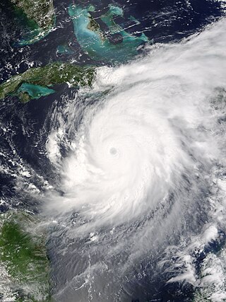
Hurricane Lili was the second costliest, deadliest, and strongest hurricane of the 2002 Atlantic hurricane season, only surpassed by Hurricane Isidore, which affected the same areas around a week before Lili. Lili was the twelfth named storm, fourth hurricane, and second major hurricane of the 2002 Atlantic hurricane season. The storm developed from a tropical disturbance in the open Atlantic on September 21. It continued westward, affecting the Lesser Antilles as a tropical storm, then entered the Caribbean. As it moved west, the storm dissipated while being affected by wind shear south of Cuba, and regenerated when the vertical wind shear weakened. It turned to the northwest and strengthened up to category 2 strength on October 1. Lili made two landfalls in western Cuba later that day, and then entered the Gulf of Mexico. The hurricane rapidly strengthened on October 2, reaching Category 4 strength that afternoon. It weakened rapidly thereafter, and hit Louisiana as a Category 1 hurricane on October 3. It moved inland and dissipated on October 6.

<span class="mw-page-title-main">Hurricane Mitch</span> Category 5 Atlantic hurricane in 1998

Hurricane Mitch was the second-deadliest Atlantic hurricane on record. Mitch caused 11,374 fatalities in Central America in 1998, including approximately 7,000 in Honduras and 3,800 in Nicaragua due to cataclysmic flooding from the slow motion of the storm. It was the deadliest hurricane in Central American history, surpassing Hurricane Fifi–Orlene, which killed slightly fewer people in that area in 1974. Mitch was the deadliest Atlantic hurricane in the satellite era, and the second-deadliest on record in the Atlantic, only behind the Great Hurricane of 1780 which killed at least 22,000 people.

<span class="mw-page-title-main">Hurricane Georges</span> Category 4 Atlantic hurricane in 1998

Hurricane Georges was a powerful and long-lived Cape Verde Category 4 hurricane which caused severe destruction as it traversed the Caribbean and Gulf of Mexico in September 1998, making seven landfalls along its path. Georges was the seventh tropical storm, fourth hurricane, and second major hurricane of the 1998 Atlantic hurricane season. It became the most destructive storm of the season, the costliest Atlantic hurricane since Hurricane Andrew in 1992 and remained the costliest until Hurricane Charley in 2004, and the deadliest since Hurricane Gordon in 1994. Georges killed 604 people, mainly on the island of Hispaniola, caused extensive damage resulting in just under $10 billion in damages and leaving nearly 500,000 people homeless in St. Kitts and Nevis, Puerto Rico, Hispaniola and Cuba.

<span class="mw-page-title-main">Hurricane Michelle</span> Category 4 Atlantic hurricane in 2001

Hurricane Michelle was the fifth costliest tropical cyclone in Cuban history and the strongest hurricane of the 2001 Atlantic hurricane season. The thirteenth named storm and seventh hurricane that year, Michelle developed from a tropical wave that had traversed into the western Caribbean Sea on October 29; the wave had initially moved off the coast of Africa 13 days prior. In its early developmental stages, the depression meandered over Nicaragua, later paralleling the Mosquito Coast before intensifying into tropical storm intensity on November 1; Michelle was upgraded to hurricane strength the following day. Shortly after, rapid intensification ensued within favorable conditions, with the storm's central barometric pressure dropping 51 mbar in 29 hours. After a slight fluctuation in strength, Michelle reached its peak intensity as a Category 4 hurricane with winds of 140 mph (230 km/h) and a minimum pressure of 933 mbar. This tied Michelle with 1999's Lenny as the fourth most powerful November hurricane on record in the Atlantic Basin, behind only the 1932 Cuba hurricane and 2020 Hurricanes Iota and Eta. At roughly the same time, the hurricane began to accelerate northeastward; this brought the intense hurricane to a Cuban landfall within the Bay of Pigs later that day. Crossing over the island, Michelle was weakened significantly, and was only a Category 1 hurricane upon reentry into the Atlantic Ocean. The hurricane later transitioned into an extratropical cyclone over The Bahamas on November 5, before being absorbed by a cold front the following day.

<span class="mw-page-title-main">Hurricane Charley</span> Category 4 Atlantic hurricane in 2004

Hurricane Charley was the first of four separate hurricanes to impact or strike Florida during 2004, along with Frances, Ivan and Jeanne, as well as one of the strongest hurricanes ever to strike the United States. It was the third named storm, the second hurricane, and the second major hurricane of the 2004 Atlantic hurricane season. Charley lasted from August 9 to 15, and at its peak intensity it attained 150 mph (240 km/h) winds, making it a strong Category 4 hurricane on the Saffir–Simpson scale. It made landfall in Southwest Florida at maximum strength, making it the strongest hurricane to hit the United States since Hurricane Andrew struck Florida in 1992 and tied with Hurricane Ian as the strongest hurricane to hit southwest Florida in recorded history.

<span class="mw-page-title-main">Hurricane Inez</span> Category 5 Atlantic hurricane in 1966

Hurricane Inez was a powerful Category 5 major hurricane that affected the Caribbean, Bahamas, Florida, and Mexico, killing over 1,000 people in 1966. It was the first storm on record to affect all of those areas. It originated from a tropical wave over Africa, and became a tropical depression by September 21. It moved slowly westward, initially failing to intensify much; it was upgraded to Tropical Storm Inez on September 24. The storm strengthened into a hurricane and was quickly intensifying when it struck the French overseas region of Guadeloupe on September 27. Inez severely damaged the island's banana and sugar crops, and thousands of homes were damaged, leaving 10,000 people homeless. Damage on Guadeloupe was estimated at $50 million, and there were 40 deaths. After entering the Caribbean, Inez briefly weakened before restrengthening, attaining peak sustained winds of 165 mph (270 km/h) on September 28, eventually making landfall at that intensity in the Dominican Republic. That day a hurricane hunters flight reported a gust of 197 mph (317 km/h), which was the highest recorded at the time.

<span class="mw-page-title-main">Hurricane Ivan</span> Category 5 Atlantic hurricane in 2004

Hurricane Ivan was a large, long-lived, Cape Verde hurricane that caused widespread damage in the Caribbean and United States. The cyclone was the ninth named storm, the sixth hurricane and the fourth major hurricane of the active 2004 Atlantic hurricane season.

<span class="mw-page-title-main">Hurricane Flora</span> Category 4 Atlantic hurricane in 1963

Hurricane Flora is among the deadliest Atlantic hurricanes in recorded history, with a death total of at least 7,193. The seventh tropical storm and sixth hurricane of the 1963 Atlantic hurricane season, Flora developed from a disturbance in the Intertropical Convergence Zone on September 26 while located 755 miles (1,215 km) southwest of the Cape Verde islands. After remaining a weak depression for several days, it rapidly organized on September 29 to attain tropical storm status. Flora continued to quickly strengthen to reach Category 3 hurricane status before moving through the Windward Islands and passing over Tobago, and it reached maximum sustained winds of 145 miles per hour (233 km/h) in the Caribbean.

<span class="mw-page-title-main">1928 Okeechobee hurricane</span> Category 5 Atlantic hurricane

The Okeechobee hurricane of 1928, also known as the San Felipe Segundo hurricane, was one of the deadliest hurricanes in the recorded history of the North Atlantic basin, and the fourth deadliest hurricane in the United States, only behind the 1900 Galveston hurricane, 1899 San Ciriaco hurricane, and Hurricane Maria. The hurricane killed an estimated 2,500 people in the United States; most of the fatalities occurred in the state of Florida, particularly in Lake Okeechobee. It was the fourth tropical cyclone, third hurricane, the only major hurricane of the 1928 Atlantic hurricane season, and remains the deadliest disaster in Florida’s history to date. It developed off the west coast of Africa on September 6 as a tropical depression, but it strengthened into a tropical storm later that day, shortly before passing south of the Cape Verde islands. Further intensification was slow and halted late on September 7. About 48 hours later, the storm strengthened and became a Category 1 hurricane on the Saffir–Simpson hurricane wind scale. Still moving westward, the system reached Category 4 intensity before striking Guadeloupe on September 12, where it brought great destruction and resulted in 1,200 deaths. The islands of Martinique, Montserrat, and Nevis also reported damage and fatalities, but not nearly as severe as in Guadeloupe.

<span class="mw-page-title-main">1899 Atlantic hurricane season</span>

The 1899 Atlantic hurricane season featured the longest-lasting tropical cyclone in the Atlantic basin on record. There were nine tropical storms, of which five became hurricanes. Two of those strengthened into major hurricanes, which are Category 3 or higher on the modern day Saffir–Simpson scale. The first system was initially observed in the northeastern Gulf of Mexico on June 26. The tenth and final system dissipated near Bermuda on November 10. These dates fall within the period with the most tropical cyclone activity in the Atlantic. In post-season analysis, two tropical cyclones that existed in October were added to HURDAT – the official Atlantic hurricane database. At one point during the season, September 3 through the following day, a set of three tropical cyclones existed simultaneously.

<span class="mw-page-title-main">1899 San Ciriaco hurricane</span> Category 4 Atlantic hurricane

The 1899 San Ciríaco hurricane, also known as the 1899 Puerto Rico Hurricane or The Great Bahamas Hurricane of 1899, was the longest-lived Atlantic hurricane on record, and the third-longest-lived tropical cyclone globally on record after 1994's Hurricane John in the Pacific Ocean and 2023's Cyclone Freddy in the southern Indian Ocean. It was also one of the deadliest Atlantic hurricanes in recorded history, with an estimated 3,800 fatalities. The third tropical cyclone and first major hurricane of the season, this storm was first observed southwest of Cape Verde on August 3. It slowly strengthened while heading steadily west-northwestward across the Atlantic Ocean and reached hurricane status by late on August 5. During the following 48 hours, it deepened further, reaching Category 4 on the modern day Saffir–Simpson hurricane wind scale (SSHWS) before crossing the Leeward Islands on August 7. Later that day, the storm peaked with winds of 150 mph (240 km/h). The storm weakened slightly before making landfall in Guayama, Puerto Rico with winds of 140 mph (220 km/h) on August 8. Several hours later, it emerged into the southwestern Atlantic as a Category 3 hurricane. The system paralleled the north coast of Dominican Republic and then crossed the Bahamas, striking several islands. Then, on August 14, it started to move north while still being located east of Florida. The storm recurved northeastward early the next morning and appeared to be moving out to sea. However, by August 17, it turned back to the northwest and made landfall near Hatteras, North Carolina early on the following day. No stronger hurricane has made landfall on the Outer Banks since the San Ciriaco hurricane.

<span class="mw-page-title-main">Hurricane Lili (1996)</span> Category 3 Atlantic hurricane in 1996

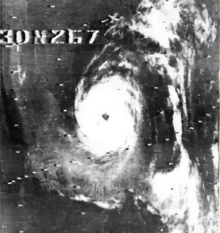
Hurricane Lili was a relatively long-lived hurricane of the 1996 Atlantic hurricane season that affected countries from Central America to the United Kingdom. Lili formed on October 14 from a tropical wave, which emerged from the coast of west Africa on October 4. After the storm formed, further strengthening of Lili was gradual, first to tropical storm status on October 16 and then to hurricane status on October 17. The next day, Lili struck Cuba and moved across the central portion of the island, the first hurricane to hit the country since Hurricane Kate in 1985. After emerging into the Atlantic Ocean, the hurricane accelerated northeastward, briefly peaking as a category 3 hurricane on the Saffir-Simpson Hurricane Scale near the Bahamas. For almost an entire week, Hurricane Lili oscillated in intensity while fluctuating several times in forward speed. About two weeks passed before Lili transitioned into an extratropical storm north of the Azores on October 27, which subsequently moved across Ireland and Great Britain.

<span class="mw-page-title-main">Effects of Hurricane Dean in the Lesser Antilles</span>

The effects of Hurricane Dean in the Lesser Antilles were spread over five island countries and included 3 fatalities. Hurricane Dean formed in the Atlantic Ocean west of Cape Verde on August 14, 2007. The National Hurricane Center's first Forecast Advisory on the system anticipated that the Cape Verde-type hurricane would pass into the Caribbean through the Lesser Antilles. The storm moved persistently towards the small island chain, strengthening until it passed through the islands three days later on August 17 as a Category 2 hurricane on the Saffir-Simpson Hurricane Scale. It went on to brush the island of Jamaica and reached Category 5 strength before making landfall on Mexico's Yucatán Peninsula.

<span class="mw-page-title-main">Effects of Hurricane Georges in the Lesser Antilles</span>

The effects of Hurricane Georges in the Lesser Antilles were minimal in certain islands and major on others. Georges had formed on September 15, 1998, off the African coast. It had quickly strengthened into a Category 4 hurricane on the Saffir–Simpson scale on September 20 when it struck the Lesser Antilles with 115 mph (185 km/h) winds. The islands affected include Antigua, Barbuda, the British Virgin Islands, the United States Virgin Islands, Montserrat, Guadeloupe, Dominica, St. Maarten. St. Kitts and Nevis were also affected and sustained the most damage at US$484 million.

<span class="mw-page-title-main">Effects of Hurricane Georges in Cuba</span>

The effects of Hurricane Georges in Cuba included $305.8 million in damages and six deaths. Forming out of a tropical wave over the Atlantic Ocean, Georges attained a peak intensity of 155 mph (249 km/h) on September 20, 1998. On September 23, the storm made landfall in southeastern Cuba as a minimal Category 1 hurricane. The storm tracked over the county for the following two days before emerging into the Gulf of Mexico on September 25 and later making landfall in the United States as a Category 2 hurricane. Before the storm's landfall in Cuba, officials reported that 200,000 people were evacuated to shelters; however, later reports indicated that upwards 711,000 people evacuated. A state of emergency was declared for much of eastern Cuba and most of the country was placed under a tropical storm or hurricane warning during the storm's passage.

<span class="mw-page-title-main">Effects of Hurricane Dennis in Jamaica</span>

In early July 2005, Hurricane Dennis brushed Jamaica, bringing torrential rain and damaging floods to the island nation. Forming from a tropical depression on July 4, Dennis began impacting Jamaica three days later. Approximately 6,000 people evacuated from coastal and flood-prone areas prior to the storm's arrival while relief agencies allocated resources for recovery operations. Passing northeast of the island, impact from Dennis stemmed primarily from rainfall—accumulations peaked at 24.54 in (623 mm) and reached 1-in-50 year event levels. Widespread flooding and landslides damaged homes and isolated communities. Saint Thomas and Portland Parishes were hardest-hit; hundreds required evacuation as multiple rivers burst their banks.

<span class="mw-page-title-main">Effects of Hurricane Mitch in Honduras</span>

The effects of Hurricane Mitch in Honduras were destructive and deadly, resulting in the most significant flooding in Honduras in the 20th century. Hurricane Mitch, the strongest storm of the 1998 Atlantic hurricane season, formed on October 22, and after becoming a Category 5 hurricane, it weakened and struck Honduras on October 29. While near peak intensity, Mitch struck the offshore Guanaja island, where it nearly destroyed the mangrove forest. On the mainland, the hurricane dropped torrential rainfall, and many gauges were washed away in mountainous areas where unofficial rainfall totals were as high as 1900 mm (75 in). The highest official total was 928 mm (36.5 in) at Choluteca in southern Honduras, which was more than half of the annual precipitation average there. The rains caused widespread flooding and landslides, although impact from winds was not as severe.

<span class="mw-page-title-main">1903 Jamaica hurricane</span> Category 3 Atlantic hurricane in 1903

The 1903 Jamaica hurricane devastated Martinique, Jamaica, and the Cayman Islands in August 1903. The second tropical cyclone of the season, the storm was first observed well east of the Windward Islands on August 6. The system moved generally west-northwestward and strengthened into a hurricane on August 7. It struck Martinique early on August 9, shortly before reaching the Caribbean. Later that day, the storm became a major hurricane. Early on August 11, it made landfall near Morant Point, Jamaica, with winds of 120 mph (195 km/h), with would be the hurricane's maximum sustained wind speed. Early on the following day, the storm brushed Grand Cayman at the same intensity. The system weakened before landfall near Playa del Carmen, Quintana Roo, early on August 13, with winds of 100 mph (160 km/h). The system emerging into the Gulf of Mexico early on August 14 after weakening while crossing the Yucatán Peninsula, but failed to re-strengthen. Around 00:00 UTC on August 16, the cyclone made landfall north of Tampico, Tamaulipas, with winds of 80 mph (130 km/h). The hurricane soon weakened to a tropical storm and dissipated over San Luis Potosí late on August 16.

<span class="mw-page-title-main">1893 San Roque hurricane</span> Category 3 Atlantic hurricane in 1893

Hurricane San Roque was a destructive tropical cyclone in August 1893 that principally affected Puerto Rico, eastern New England, and Atlantic Canada. Its informal name in Puerto Rico arises from the feast day of Saint Roch, or San Roque in Spanish, which coincided with the hurricane's landfall on that island. It was the third known hurricane of the 1893 Atlantic hurricane season. The system was first observed on August 13 at low latitudes east of the Lesser Antilles. It grew to be a powerful, slow-moving hurricane in the Caribbean Sea, and on August 17 struck Puerto Rico at the equivalence of Category 3 on the modern-day Saffir–Simpson scale. The eye crossed the island from southeast to northwest in about seven hours. A prolonged period of strong winds caused widespread destruction on the island, most notably along the northern coast. Large numbers of homes sustained varying degrees of damage, with flimsy shacks belonging to poor workers faring the worst; many families were left homeless, and four people were killed. Telegraph communications were severed across the island. In addition to the intense winds, several days of heavy rainfall in interior sectors triggered extensive river flooding. The combined effects of rain and wind destroyed fields of crops, most notably coffee and sugar cane.

<span class="mw-page-title-main">Hurricanes in Hispaniola</span>

Hispaniola is an island in the Caribbean, with the second largest size throughout all of the Caribbean. Throughout the centuries, since reliable records began, hundreds of hurricanes and tropical cyclones have affected Haiti and the Dominican Republic, the two countries that share the island. The most recent tropical cyclone to affect Hispaniola was Hurricane Franklin in August 2023.

References

  1. 1 2 3 4 Church, Christopher (September 2017). "Hurricane Katrina and its Antecedents" (Document). University of Nevada, Reno.
  2. Church, Christopher (August 2017). "Environmental History: An Introduction" (Document). University of Nevada, Reno.
  3. 1 2 3 4 5 Tanner, E. V. J.; Kapos, V.; Healey, J.R. (1991). "Hurricane effects on forest ecosystems in the Caribbean". Biotropica. 23 (4): 513–521. doi:10.2307/2388274. JSTOR   2388274.
  4. Van Bloem, Skip J.; Murphy, Peter G.; Lugo, Ariel E.; Ostertag, Rebecca; Rivera Costa, Maria; Bernard, Ivelisse Ruiz; Colon, Sandra Molina; Mora, Miguel Canals (2005). "The influence of hurricane winds on Caribbean dry forest structure and nutrient pools". Biotropica. 37 (4).
  5. 1 2 3 4 5 6 7 8 9 10 11 12 Schwartz, Stuart B. (2015). Sea of storms: a history of hurricanes in the Greater Caribbean from Columbus to Katrina. Princeton University Press.
  6. 1 2 3 4 5 6 7 Johnson, Sherry (2011). Climate and Catastrophe in Cuba and the Atlantic World in the Age of Revolution. University of North Carolina Press.
  7. 1 2 3 4 5 6 Schwartz, Stuart B. (1992). "The hurricane of San Ciriaco: disaster, politics, and society in Puerto Rico, 1899-1901". The Hispanic American Historical Review. 72 (3).
  8. 1 2 3 4 5 Johnson, Sherry (September 2015). "The History and Science of Hurricanes in the Greater Caribbean". Oxford Research Encyclopedia of Latin American History. doi:10.1093/acrefore/9780199366439.013.57. ISBN   9780199366439 . Retrieved 6 December 2017.
  9. "Haitian Revolution | Causes, Summary, & Facts". Encyclopedia Britannica. Retrieved 2019-12-16.
  10. 1 2 3 Stinchombe, Arthur (1995). Sugar Island Slavery in the Age of Enlightenment: The Political Economy of the Caribbean World. Princeton University Press.
  11. 1 2 3 Perez, Louis (2001). Winds of Change: Hurricanes and the Transformation of Nineteenth-Century Cuba. University of North Carolina Press.
  12. 1 2 3 Perez, Louis (1992). Slaves, Sugar, and Colonial Society: Travel Accounts of Cuba, 1801-1899. SR Books.
  13. 1 2 3 Mohan, Preeya; Strobl, Eric (2013). "The economic impact of hurricanes in history: evidence from sugar exports in the Caribbean from 1700 to 1960". Weather, Climate, and Society. 5 (1): 5–13. doi: 10.1175/WCAS-D-12-00029.1 .
  14. 1 2 3 4 5 Prevatt, D.O.; Dupigny-Giroux, L-A.; Masters, F. J. (2010). "Engineering perspectives on reducing hurricane damage to housing in CARICOM Caribbean Islands". Natural Hazards Review. 11 (4): 140–150. doi:10.1061/(ASCE)NH.1527-6996.0000017.
  15. Pielke, Jr; A., Roger; Rubiera, Jose; Landsea, Christopher; Fernández, Mario L.; Klein, Roberta (2003). "Hurricane vulnerability in Latin America and the Caribbean: Normalized damage and loss potentials". Natural Hazards Review. 4 (3): 112. doi:10.1061/(ASCE)1527-6988(2003)4:3(101).