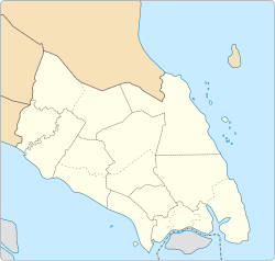
The Batu Pahat District is a district in the state of Johor, Malaysia. It lies southeast of Muar, southwest of Kluang, northwest of Pontian, south of Segamat and Tangkak District. The capital of the district is Bandar Penggaram.

The Johor Bahru District is a district located in the southern part of Johor, Malaysia. The heavily suburban/suburbanizing district covers an area of 1,063.97 km2 (410.80 sq mi) and has a population of 1.33 million. The district capital is Johor Bahru City and the administrative capital is Iskandar Puteri City. The district borders Pontian District on the west, Kota Tinggi District on the east, Kulai District on the north and Straits of Johor to the south. The urban centres are divided into the cities of Johor Bahru, Iskandar Puteri and Pasir Gudang.

Taman Johor Jaya is a suburb in Johor Bahru, Johor, Malaysia. Johor Jaya consists of mainly residential zones, but it also has light industrial and commercial zones.
Johor Bahru, Malaysia, has the following notable landmarks.
Skudai is a suburb in Iskandar Puteri, Johor Bahru District, Johor, Malaysia. Skudai is part of the new growth corridor of southwest Johor. Its population ranges between 160,000 and 210,000. It houses the Paradigm Mall Johor and the headquarters of the Iskandar Puteri City Council, and is home to the Universiti Teknologi Malaysia campus.

Masai is an area in Pasir Gudang, Johor Bahru District, Johor, Malaysia, and is the oldest neighbourhood of Johor Bahru town. It is located 25 kilometres from the Johor Bahru city centre. Masai is located on route J10 which leads to Kong Kong, a fishing village along Johor River. The main access roads to Masai are Jalan Masai Lama (J10) and Pasir Gudang Highway.

Permas Jaya, with the official name of Bandar Baru Permas Jaya, is a suburb in Johor Bahru, Johor, Malaysia. It has about 40,000-45,000 residents. The Permas Jaya Bridge connects it with Kampung Baru Bakar Batu, Taman Sentosa and downtown Johor Bahru. The Second Permas Jaya Bridge is completed and had helped to reduce traffic jams. The new Eastern Dispersal Link has also been completed and opened for public on 1 April 2012.

Chaah is a town and mukim in Segamat District, Johor, Malaysia. It is the southernmost mukim in the district, but it is administered as a suburb of Labis.

Plentong is a mukim in Johor Bahru District, Johor, Malaysia.

Majidee Malay Village is a Malay village located in the city of Johor Bahru, Johor, Malaysia. Its population is around 30,000.

Floods in Malaysia are regular natural disasters in Malaysia which happen nearly every year especially during the monsoon season. The east coast of peninsular Malaysia is the most prone to flooding especially during the northeast monsoon season from October to March.

The Cathedral of the Sacred Heart of Jesus is a church located in Taman Sri Tebrau, Johor Bahru, Johor, Malaysia. The Cathedral itself is also situated in the heart of the most densely populated area in Johor Bahru, surrounded by housing estates such as Melodies Garden, Taman Sri Tebrau, Taman Pelangi, Century Garden, Taman Sentosa, Kebun Teh and Majidee Park.

Taman Ungku Tun Aminah is a suburb in Skudai, Iskandar Puteri, Johor Bahru District, Johor, Malaysia. It was erected on 1980s after Sultanah Tun Aminah.
The Permas Jaya-Pasir Gudang Road orJohor Bahru East Coast Highway, Federal Route 35, is a major highway in Johor Bahru, Johor, Malaysia. It is a toll free highway and part of the Iskandar Malaysia project. This 13.4 km highway connects Bakar Batu in city centre to the town of Pasir Gudang, and passes through Bandar Baru Permas Jaya and Taman Rinting. This highway also passes through Permas Jaya Bridge and is the alternative way to Pasir Gudang besides Pasir Gudang Highway. Johor Bahru East Coast Highway is the fourth east–west-oriented expressway in the Iskandar Malaysia area after the Pasir Gudang Highway, the Pontian–Johor Bahru Link of the Second Link Expressway and the Senai–Desaru Expressway.

Tebrau or Teberau is a mukim and a suburb in Johor Bahru District, Johor, Malaysia. It is the third largest mukim in the district.
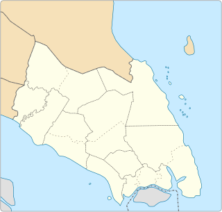
Batu Pahat (BP) is a city and capital of Batu Pahat District, Johor, Malaysia. It lies south-east of Muar, south-west of Kluang, north-west of Pontian and south of Segamat. The town area is located inside Simpang Kanan parishes.
Chamek is a village in Kluang District, Johor, Malaysia. The name originated from the Chinese variation of the word Jambi, which is rather hard to pronounce.