Kandi Fault Zone

Last updated

The Kandi fault zone is a southern extension of the Hoggar fault zone in West Africa, with splays in Benin, Togo and southeastern Ghana. It lies at the southern end of the Trans Saharan belt, a lineament that extends in a southwest direction from Algeria to Benin. The Kandi fault zone is identified with the Sobral fault in northeastern Brazil, considered to be the northern section of the Trans Brazilian Lineament. [1]

West Africa Westernmost region of the African continent

West Africa is the westernmost region of Africa. The United Nations defines Western Africa as the 16 countries of Benin, Burkina Faso, Cape Verde, The Gambia, Ghana, Guinea, Guinea-Bissau, Ivory Coast, Liberia, Mali, Mauritania, the Niger, Nigeria, Senegal, Sierra Leone and Togo, as well as the United Kingdom Overseas Territory of Saint Helena, Ascension and Tristan da Cunha. The population of West Africa is estimated at about 362 million people as of 2016, and at 381,981,000 as of 2017, of which 189,672,000 are female and 192,309,000 male.

Benin country in Africa

Benin, officially the Republic of Benin and formerly Dahomey, is a country in West Africa. It is bordered by Togo to the west, Nigeria to the east, and Burkina Faso and Niger to the north. The majority of its population lives on the small southern coastline of the Bight of Benin, part of the Gulf of Guinea in the northernmost tropical portion of the Atlantic Ocean. The capital of Benin is Porto-Novo, but the seat of government is in Cotonou, the country's largest city and economic capital. Benin covers an area of 114,763 square kilometres (44,310 sq mi) and its population in 2016 was estimated to be approximately 10.87 million. Benin is a tropical nation, highly dependent on agriculture, and is a large exporter of cotton and palm oil. Substantial employment and income arise from subsistence farming.

Togo Country in Africa

Togo, officially the Togolese Republic, is a country in West Africa bordered by Ghana to the west, Benin to the east and Burkina Faso to the north. The sovereign state extends south to the Gulf of Guinea, where its capital Lomé is located. Togo covers 57,000 square kilometres, making it one of the smallest countries in Africa, with a population of approximately 7.6 million.

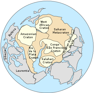
The Kandi fault is a band about 400 m thick of ultramylonites with shallow-plunging stretching lineations. [2] The nature of the deposits of the Kandi Basin indicate that they were formed during the melting of the wide ice sheet that overlay the Afro-Arabian Shield during Late Ordovician times. [3] Kandi lies at the southern end of the Trans Saharan Kandi/4°50' lineament, which represents a suture resulting from an oblique collision between the West African craton and the Sao Francisco / Congo craton. The Sobral shear zone of the Transbrasiliano lineament is considered a continuation of this lineament. [4] The fit between the continental margins of South America and Africa is poor in this region, in contrast to the excellent fit to the west and south, but this can be explained by splay faults created during the separation of the continents. [5]

Mylonite fine-grained, compact metamorphic rock produced by dynamic recrystallization of the constituent minerals

Mylonite is a fine-grained, compact metamorphic rock produced by dynamic recrystallization of the constituent minerals resulting in a reduction of the grain size of the rock. Mylonites can have many different mineralogical compositions; it is a classification based on the textural appearance of the rock.

The Ordovician is a geologic period and system, the second of six periods of the Paleozoic Era. The Ordovician spans 41.2 million years from the end of the Cambrian Period 485.4 million years ago (Mya) to the start of the Silurian Period 443.8 Mya.

South America A continent in the Western Hemisphere, and mostly in the Southern Hemisphere

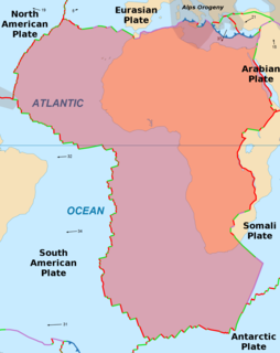
South America is a continent in the Western Hemisphere, mostly in the Southern Hemisphere, with a relatively small portion in the Northern Hemisphere. It may also be considered a subcontinent of the Americas, which is how it is viewed in the Spanish and Portuguese-speaking regions of the Americas. The reference to South America instead of other regions has increased in the last decades due to changing geopolitical dynamics.

Related Research Articles

African Plate Tectonic plate underlying Africa west of the East African Rift

The African Plate is a major tectonic plate straddling the equator as well as the prime meridian. It includes much of the continent of Africa, as well as oceanic crust which lies between the continent and various surrounding ocean ridges. Between 60 million years ago and 10 million years ago, the Somali Plate began rifting from the African Plate along the East African Rift. Since the continent of Africa consists of crust from both the African and the Somali plates, some literature refers to the African Plate as the Nubian Plate to distinguish it from the continent as a whole.

Pannotia Hypothesized Neoproterozoic supercontinent from the end of the Precambrian

Pannotia, also known as Vendian supercontinent, Greater Gondwana, and the Pan-African supercontinent, was a relatively short-lived Neoproterozoic supercontinent that formed at the end of the Precambrian during the Pan-African orogeny and broke apart 560 Ma with the opening of the Iapetus Ocean. Pannotia formed when Laurentia was located adjacent to the two major South American cratons, Amazonia and Río de la Plata. The opening of the Iapetus Ocean separated Laurentia from Baltica, Amazonia, and Río de la Plata.

The Pan-African orogeny was a series of major Neoproterozoic orogenic events which related to the formation of the supercontinents Gondwana and Pannotia about 600 million years ago. This orogeny is also known as the Pan-Gondwanan or Saldanian Orogeny. The Pan-African orogeny and the Grenville orogeny are the largest known systems of orogenies on Earth. The sum of the continental crust formed in the Pan-African orogeny and the Grenville orogeny makes the Neoproterozoic the period of Earth's history that has produced most continental crust.

Vaalbara Archaean supercontinent from about 3.6 to 2.7 billion years ago

Vaalbara was an Archean supercontinent consisting of the Kaapvaal Craton and the Pilbara Craton. E. S. Cheney derived the name from the last four letters of each craton's name. The two cratons consist of crust dating from 2.7 to 3.6 Gya, which would make Vaalbara one of Earth's earliest supercontinents.

North China Craton A continental crustal block in northeast China, Inner Mongolia, the Yellow Sea, and North Korea

The North China Craton is a continental crustal block with one of Earth's most complete and complex records of igneous, sedimentary and metamorphic processes. It is located in northeast China, Inner Mongolia, the Yellow Sea, and North Korea. The term craton designates this as a piece of continent that is stable, buoyant and rigid. Basic properties of the cratonic crust include being thick, relatively cold when compared to other regions, and low density. The North China Craton is an ancient craton, which experienced a long period of stability and fitted the definition of a craton well. However, the North China Craton later experienced destruction of some of its deeper parts (decratonization), which means that this piece of continent is no longer as stable.

Río de la Plata Craton A medium-sized continental block in Uruguay, eastern Argentina and southern Brazil

The Rio de la Plata Craton (RPC) is a medium-sized continental block found in Uruguay, eastern Argentina and southern Brazil. During its complex and protracted history it interacted with a series other blocks and is therefore considered important for the understanding of the amalgamation of West Gondwana. Two orogenic cycles have been identified in the RPC: a 2000 Ma-old western domain representing the old craton and a 700–500 Ma-old eastern domain assigned to the Brasiliano Cycle. It is one of the five cratons of the South American continent. The other four cratons are: Amazonia, São Francisco, Río Apa and Arequipa–Antofalla.

See also Line (geometry)

The Tornquist Sea or Tornquist Ocean was a sea located between the palaeocontinents Avalonia and Baltica about 600 to 450 million years ago. The remains of the sea today form a suture stretching across northern Europe.

Brothers Fault Zone

The Brothers Fault Zone (BFZ) is the most notable of a set of northwest-trending fault zones including the Eugene–Denio, McLoughlin, and Vale zones that dominate the geological structure of most of Oregon. These are also representative of a regional pattern of generally northwest-striking geological features ranging from Walker Lane on the California–Nevada border to the Olympic–Wallowa Lineament in Washington; these are generally associated with the regional extension and faulting of the Basin and Range Province, of which the BFZ is considered the northern boundary.

São Francisco Craton An ancient craton in the eastern part of South America with outcrops in Minas Gerais and Bahia, Brazil

The São Francisco Craton is an ancient craton in the eastern part of South America. The craton crops out in the Brazilian states of Minas Gerais and Bahia.

Saharan Metacraton A large area of continental crust in the north-central part of Africa

The Saharan Metacraton is a term used by some geologists to describe a large area of continental crust in the north-central part of Africa. Whereas a craton is an old and stable part of the lithosphere, the term "metacraton" is used to describe a craton that has been remobilized during an orogenic event, but where the characteristics of the original craton are still identifiable. The geology of the continent has only been partially explored, and other names have been used to describe the general area that reflect different views of its nature and extent. These include "Nile Craton", "Sahara Congo Craton", "Eastern Saharan Craton" and "Central Saharan Ghost Craton". This last term is because the older rocks are almost completely covered by recent sediments and desert sands, making geological analysis difficult.

Tuareg Shield A geological formation between the West African craton and the Saharan Metacraton in West Africa

The Tuareg Shield is a geological formation lying between the West African craton and the Saharan Metacraton in West Africa. Named after the Tuareg people, it has complex a geology, reflecting the collision between these cratons and later events. The landmass covers parts of Algeria, Niger and Mali.

Central African Shear Zone

The Central African Shear Zone (CASZ) is a wrench fault system extending in an ENE direction from the Gulf of Guinea through Cameroon into Sudan. The structure is not well understood. As of 2008, there was still no general agreement about how the individual shears along the lineament link up.

The Trans Brazilian Lineament (TBL), or Transbrasiliano Lineament, is a major shear zone that developed in the Precambrian period, and that has been reactivated several times since then, mostly recently during the Mesozoic. Movement along the shear zone helps explain how the South American continent could have fitted tightly to the African continent before the breakup of Gondwana.

The Pharusian Ocean is an ancient ocean that existed from 800 to 635 million years ago, between the break-up of the Rodinia supercontinent and the start of formation of the Gondwana supercontinent.

The Sobral fault is a major fault in the Borborema geological province of northeastern Brazil, a part of the Transbrasiliano lineament. It is commonly correlated with the Kandi fault in Benin, east of the West African craton. The fault lies in the northwest of Ceará state. It appears to have formed late in the orogeny when the West African craton engaged with the Congo craton, and to have allowed significant dextral strike-slip movement. It was reactivated when South America was breaking away from Africa. In this later phase, a sinistral shear movement of about 100 km seems to have taken place during and after the break-up.

The Foumban Shear Zone, or Central Cameroon Shear Zone (CCSZ), is a fault zone in Cameroon that has been correlated with the Pernambuco fault in northeastern Brazil, which splays from the Trans-Brazilian Lineament. It is part of the Central African Shear Zone (CASZ) and dates to at least 640 million years ago. The zone was rejuvenated several times, usually with a dextral movement, before and during the opening of the South Atlantic in the Cretaceous period.

The Pernambuco Fault or Pernambuco Shear Zone in northeastern Brazil is a fault radiating from the Trans Brazilian Lineament eastwards to the coast, a major geological feature.

The Mwembeshi Shear Zone is a ductile shear zone about 550 million years old that extends ENE-WSW across Zambia. In Zambia, it separates the Lufilian Belt to the northwest from the Zambezi Belt to the southeast. It is associated with a sinistral strike slip movement.

References

  1. Attoh & Brown 2008.
  2. Pankhurst 2008, pp. 62.
  3. Konate et al. 2003.
  4. Pankhurst 2008, pp. 58.
  5. Fairhead, Bournas & Raddadi 2007, pp. 1.

Sources

The bibcode is a compact identifier used by several astronomical data systems to uniquely specify literature references.

Digital object identifier Character string used as a permanent identifier for a digital object, in a format controlled by the International DOI Foundation

In computing, a Digital Object Identifier or DOI is a persistent identifier or handle used to identify objects uniquely, standardized by the International Organization for Standardization (ISO). An implementation of the Handle System, DOIs are in wide use mainly to identify academic, professional, and government information, such as journal articles, research reports and data sets, and official publications though they also have been used to identify other types of information resources, such as commercial videos.

International Standard Book Number Unique numeric book identifier

The International Standard Book Number (ISBN) is a numeric commercial book identifier which is intended to be unique. Publishers purchase ISBNs from an affiliate of the International ISBN Agency.