See also
- Mwembeshi Shear Zone – Ductile shear zone across Zambia
The Damara orogeny was part of the Pan-African orogeny. The Damara orogeny occurred late in the creation of Gondwana, at the intersection of the Congo and the Kalahari cratons. [1]
The Damara orogeny involved the suturing of the Congo–São Francisco and Río de la Plata cratons at 580–550 Ma (together with India forming northern Gondwana) before the amalgamation of the Kalahari and Mawson cratons in the Kuunga–Damara orogeny at 530 Ma (southern Gondwana). [2]
The Adamastor Ocean closed southwards from the Araçuaı́ Belt (São Francisco Craton, now in South America) to the Kaoko Belt (Congo Craton, now in Africa) 580–550 Ma and 545–530 Ma Gariep Belt (Kalahari Craton, now in southern Africa). The Damara orogeny saw a peak in deformation and metamorphism at 530–500 Ma. Thrusting occurred onto the Kalahari Craton until 480 Ma. [2]
Río de la Plata docked to Congo before the closure of the Damara Belt oceans (Mozambique and Khomas) which made the Damara orogeny part of the Kuunga orogeny which stretched from Antarctica to India across Africa. All African cratons had been assembled by c. 550 Ma and the last stages of the Damara–Kuunga Orogeny (the final amalgamation of north and South Gondwana) were intra-cratonic. [2]
The Damara orogeny created the Naukluft Mountains in central Namibia between 550 Ma and 495 Ma. [1]

Rodinia was a Mesoproterozoic and Neoproterozoic supercontinent that assembled 1.26–0.90 billion years ago and broke up 750–633 million years ago. Valentine & Moores 1970 were probably the first to recognise a Precambrian supercontinent, which they named 'Pangaea I'. It was renamed 'Rodinia' by McMenamin & McMenamin 1990 who also were the first to produce a reconstruction and propose a temporal framework for the supercontinent.

Pannotia, also known as the Vendian supercontinent, Greater Gondwana, and the Pan-African supercontinent, was a relatively short-lived Neoproterozoic supercontinent that formed at the end of the Precambrian during the Pan-African orogeny, during the Cryogenian period and broke apart 560 Ma with the opening of the Iapetus Ocean, in the late Ediacaran and early Cambrian. Pannotia formed when Laurentia was located adjacent to the two major South American cratons, Amazonia and Río de la Plata. The opening of the Iapetus Ocean separated Laurentia from Baltica, Amazonia, and Río de la Plata. In 2022 the whole concept of Pannotia has been put into question by scientists who argue its existence is not supported by geochronology, "the supposed landmass had begun to break up well before it was fully assembled".

The Congo Craton, covered by the Palaeozoic-to-recent Congo Basin, is an ancient Precambrian craton that with four others makes up the modern continent of Africa. These cratons were formed between about 3.6 and 2.0 billion years ago and have been tectonically stable since that time. All of these cratons are bounded by younger fold belts formed between 2.0 billion and 300 million years ago.

The Grenville orogeny was a long-lived Mesoproterozoic mountain-building event associated with the assembly of the supercontinent Rodinia. Its record is a prominent orogenic belt which spans a significant portion of the North American continent, from Labrador to Mexico, as well as to Scotland.
The Pan-African orogeny was a series of major Neoproterozoic orogenic events which related to the formation of the supercontinents Gondwana and Pannotia about 600 million years ago. This orogeny is also known as the Pan-Gondwanan or Saldanian Orogeny. The Pan-African orogeny and the Grenville orogeny are the largest known systems of orogenies on Earth. The sum of the continental crust formed in the Pan-African orogeny and the Grenville orogeny makes the Neoproterozoic the period of Earth's history that has produced most continental crust.
The Kalahari Craton is a craton, an old and stable part of the continental lithosphere, that occupies large portions of South Africa, Botswana, Namibia and Zimbabwe. It consists of two cratons separated by the Limpopo Belt: the larger Kaapvaal Craton to the south and the smaller Zimbabwe Craton to the north. The Namaqua Belt is the southern margin of the Kaapvaal Craton.

Gondwana was a large landmass, sometimes referred to as a supercontinent. It was formed by the accretion of several cratons, beginning c. 800 to 650Ma with the East African Orogeny, the collision of India and Madagascar with East Africa, and was completed c.600 to 530 Ma with the overlapping Brasiliano and Kuunga orogenies, the collision of South America with Africa, and the addition of Australia and Antarctica, respectively. Eventually, Gondwana became the largest piece of continental crust of the Palaeozoic Era, covering an area of about 100,000,000 km2 (39,000,000 sq mi), about one-fifth of the Earth's surface. It fused with Euramerica during the Carboniferous to form Pangea. It began to separate from northern Pangea (Laurasia) during the Triassic, and started to fragment during the Early Jurassic. The final stages of break-up, involving the separation of Antarctica from South America and Australia, occurred during the Paleogene (from around 66 to 23 million years ago. Gondwana was not considered a supercontinent by the earliest definition, since the landmasses of Baltica, Laurentia, and Siberia were separated from it. To differentiate it from the Indian region of the same name, it is also commonly called Gondwanaland.
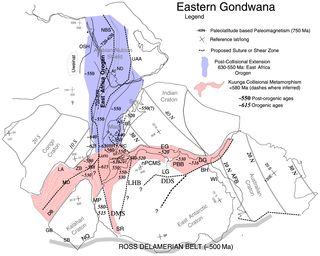
The East African Orogeny (EAO) is the main stage in the Neoproterozoic assembly of East and West Gondwana along the Mozambique Belt.
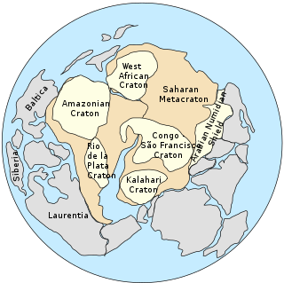
The Saharan Metacraton is a term used by some geologists to describe a large area of continental crust in the north-central part of Africa. Whereas a craton is an old and stable part of the lithosphere, the term "metacraton" is used to describe a craton that has been remobilized during an orogenic event, but where the characteristics of the original craton are still identifiable. The geology of the continent has only been partially explored, and other names have been used to describe the general area that reflect different views of its nature and extent. These include "Nile Craton", "Sahara Congo Craton", "Eastern Saharan Craton" and "Central Saharan Ghost Craton". This last term is because the older rocks are almost completely covered by recent sediments and desert sands, making geological analysis difficult.

The Mozambique Belt is a band in the earth's crust that extends from East Antarctica through East Africa up to the Arabian-Nubian Shield. It formed as a suture between plates during the Pan-African orogeny, when Gondwana was formed.
The Mwembeshi Shear Zone is a ductile shear zone about 550 million years old that extends ENE-WSW across Zambia. In Zambia, it separates the Lufilian Belt to the northwest from the Zambezi Belt to the southeast. It is associated with a sinistral strike slip movement.
The Zambezi Belt is an area of orogenic deformation in southern Zambia and northern Zimbabwe. It is a segment of a broader belt lying between the Congo Craton and the Kalahari Craton, which also includes the Lufilian Arc and the Damaran Belt. The eastern margin of the belt interacts with the north-south Eastern African orogen.

The East Antarctic Shield or Craton is a cratonic rock body that covers 10.2 million square kilometers or roughly 73% of the continent of Antarctica. The shield is almost entirely buried by the East Antarctic Ice Sheet that has an average thickness of 2200 meters but reaches up to 4700 meters in some locations. East Antarctica is separated from West Antarctica by the 100–300 kilometer wide Transantarctic Mountains, which span nearly 3,500 kilometers from the Weddell Sea to the Ross Sea. The East Antarctic Shield is then divided into an extensive central craton that occupies most of the continental interior and various other marginal cratons that are exposed along the coast.

The Svecofennian orogeny is a series of related orogenies that resulted in the formation of much of the continental crust in what is today Sweden and Finland plus some minor parts of Russia. The orogenies lasted from about 2000 to 1800 million years ago during the Paleoproterozoic Era. The resulting orogen is known as the Svecofennian orogen or Svecofennides. To the west and southwest the Svecofennian orogen limits with the generally younger Transscandinavian Igneous Belt. It is assumed that the westernmost fringes of the Svecofennian orogen have been reworked by the Sveconorwegian orogeny just as the western parts of the Transscandinavian Igneous Belt has. The Svecofennian orogeny involved the accretion of numerous island arcs in such manner that the pre-existing craton grew with this new material from what is today northeast to the southwest. The accretion of the island arcs was also related to two other processes that occurred in the same period; the formation of magma that then cooled to form igneous rocks and the metamorphism of rocks.

The Pampean orogeny was an orogeny active in the Cambrian in the western margin of the ancient landmass of Gondwana. The orogen's remains can now be observed in central Argentina, in particular at the Sierras de Córdoba and other parts of the eastern Sierras Pampeanas. It is uncertain if the orogeny involved at some point a continental collision. The Pampean orogen can be considered both part of the larger Terra Australis orogen and of the Brasiliano orogeny. The Pampean orogeny was succeeded by the Famatinian orogeny further west.
The Adamastor Ocean was a "proto-Atlantic" ocean that formed with the break-up of the Rodinia supercontinent c. 780–750 Ma. It separated the Río de la Plata Craton from the Congo Craton. The inversion of the Adamastor Ocean began about 640 Ma with the development of a large back-arc basin along the western margin of the Kalahari Craton, and the ocean closed when Río de la Plata collided with Kalahari about 545 Ma along the sinistral Sierra Ballena Shear Zone. The São Francisco Craton and the Río de la Plata Craton amalgamated 630–620 Ma, closing the Adamastor Ocean on the South American side and forming the Mantiqueira Mountains around 600 Ma.

The Owambo Basin is a sedimentary basin located on the Congo Craton in Southern Africa that extends from southern Angola into Namibia and includes the Etosha Pan. It is bound on the southern and western sides by the Damara Belt in Northern Namibia, and by the Cubango River to the East. The northern boundary is scientifically disputed, but is currently mapped by most stratigraphers to include southern Angola with the boundary set at the Kunene River. The Owambo Basin is host to two famous regions: Tsumeb, a major Namibian city and site of a formerly active copper mine with exceptional mineralogical variability producing museum quality rare specimens, and Etosha National Park, the largest protected wildlife sanctuary in Namibia centered around Etosha Pan.

The geology of Namibia encompasses rocks of Paleoproterozoic, Mesoproterozoic and Neoproterozoic and Paleozoic to Cenozoic age. About 46% of the countryʼs surface are bedrock exposure, while the remainder is covered by the young overburden sediments of the Kalahari and Namib deserts.
The Superior Craton is a stable crustal block covering Quebec, Ontario, and southeast Manitoba in Canada, and northern Minnesota in the United States. It is the biggest craton among those formed during the Archean period. A craton is a large part of the Earth's crust that has been stable and subjected to very little geological changes over a long time. The size of Superior Craton is about 1,572,000 km2. The craton underwent a series of events from 4.3 to 2.57 Ga. These events included the growth, drifting and deformation of both oceanic and continental crusts.
| | This orogeny article is a stub. You can help Wikipedia by expanding it. |
| | This palaeogeography article is a stub. You can help Wikipedia by expanding it. |