Taoudeni Basin

Last updated
Approximate extent of Taoudeni basin Taoudeni Basin Map.gif
Approximate extent of Taoudeni basin
Major West African sedimentary basins West African Basins.svg
Major West African sedimentary basins

The Taoudeni Basin is a major Sedimentary basin in West Africa, named after the Taoudenni village in northern Mali. It covers large parts of the West African craton in Mauritania and Mali. It is of considerable interest due to its possible reserves of oil. [1] In addition to its economic importance, the basin contains scientifically important fossils from the Late Mesoproterozoic and Early Neoproterozoic eras, which correspond to a time interval known as the Boring Billion. [2]

Contents

Description

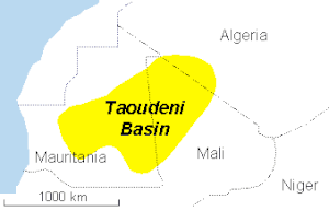
The Taoudeni is the largest sedimentary basin in Northwest Africa, formed during the Middle to Late Proterozoic. It continued to subside until the Middle Paleozoic, when Hercynian deformation and uplift occurred. It contains up to 6,000 metres (20,000 ft) of Late Precambrian and Paleozoic sediments. Exploratory drilling since the 1980s has found indications of petroleum in the Late Precambrian, Silurian and Late Devonian formations. [3]

Sediments are thicker in the western half of the basin. [4]

Petroleum geology

Possible cross-section of central Taoudeni Basin Taoudeni Basin Section.gif
Possible cross-section of central Taoudeni Basin

The government of Mali, one of the poorest countries in the world, is eager to create an oil industry. [5] Companies that have been exploring in the area include Baraka Petroleum, Sonatrach, Eni, Total S.A., Woodside and CNPC. [6]

However, the remote location and harsh environment of the Sahara Desert would make extraction expensive. [7]

Related Research Articles

<span class="mw-page-title-main">Geography of Mali</span>

Mali is a landlocked nation in West Africa, located southwest of Algeria, extending south-west from the southern Sahara Desert through the Sahel to the Sudanian savanna zone. Mali's size is 1,240,192 square kilometers.

<span class="mw-page-title-main">Geology of the Appalachians</span> Geologic description of the Appalachian Mountains

The geology of the Appalachians dates back more than 1.2 billion years to the Mesoproterozoic era when two continental cratons collided to form the supercontinent Rodinia, 500 million years prior to the development of the range during the formation of Pangea. The rocks exposed in today's Appalachian Mountains reveal elongate belts of folded and thrust faulted marine sedimentary rocks, volcanic rocks, and slivers of ancient ocean floor—strong evidences that these rocks were deformed during plate collision. The birth of the Appalachian ranges marks the first of several mountain building plate collisions that culminated in the construction of Pangea with the Appalachians and neighboring Anti-Atlas mountains near the center. These mountain ranges likely once reached elevations similar to those of the Alps and the Rocky Mountains before they were eroded.

<span class="mw-page-title-main">Congo Craton</span> Precambrian craton that with four others makes up the modern continent of Africa

The Congo Craton, covered by the Palaeozoic-to-recent Congo Basin, is an ancient Precambrian craton that with four others makes up the modern continent of Africa. These cratons were formed between about 3.6 and 2.0 billion years ago and have been tectonically stable since that time. All of these cratons are bounded by younger fold belts formed between 2.0 billion and 300 million years ago.

<span class="mw-page-title-main">Geology of the Falkland Islands</span>

The geology of the Falkland Islands is described in several publications. The Falkland Islands are located on a projection of the Patagonian continental shelf. In ancient geological time this shelf was part of Gondwana, which around 400 million years ago broke from what is now Africa and drifted westwards relative to Africa. Studies of the seabed surrounding the islands indicated the possibility of oil. Intensive exploration began in 1996, although there had been some earlier seismic surveys in the region.

<span class="mw-page-title-main">Geology of Texas</span> Overview of the geology of the U.S. state of Texas

Texas contains a wide variety of geologic settings. The state's stratigraphy has been largely influenced by marine transgressive-regressive cycles during the Phanerozoic, with a lesser but still significant contribution from late Cenozoic tectonic activity, as well as the remnants of a Paleozoic mountain range.

The West African Craton (WAC) is one of the five cratons of the Precambrian basement rock of Africa that make up the African Plate, the others being the Kalahari craton, Congo craton, Saharan Metacraton and Tanzania Craton. Cratons themselves are tectonically inactive, but can occur near active margins, with the WAC extending across 14 countries in Western Africa, coming together in the late Precambrian and early Palaeozoic eras to form the African continent. It consists of two Archean centers juxtaposed against multiple Paleoproterozoic domains made of greenstone belts, sedimentary basins, regional granitoid-tonalite-trondhjemite-granodiorite (TTG) plutons, and large shear zones. The craton is overlain by Neoproterozoic and younger sedimentary basins. The boundaries of the WAC are predominantly defined by a combination of geophysics and surface geology, with additional constraints by the geochemistry of the region. At one time, volcanic action around the rim of the craton may have contributed to a major global warming event.

<span class="mw-page-title-main">Geology of Russia</span> Overview of the geology of Russia

The geology of Russia, the world's largest country, which extends over much of northern Eurasia, consists of several stable cratons and sedimentary platforms bounded by orogenic (mountain) belts.

<span class="mw-page-title-main">East Antarctic Shield</span> Cratonic rock body which makes up most of the continent Antarctica

The East Antarctic Shield or Craton is a cratonic rock body that covers 10.2 million square kilometers or roughly 73% of the continent of Antarctica. The shield is almost entirely buried by the East Antarctic Ice Sheet that has an average thickness of 2200 meters but reaches up to 4700 meters in some locations. East Antarctica is separated from West Antarctica by the 100–300 kilometer wide Transantarctic Mountains, which span nearly 3,500 kilometers from the Weddell Sea to the Ross Sea. The East Antarctic Shield is then divided into an extensive central craton that occupies most of the continental interior and various other marginal cratons that are exposed along the coast.

<span class="mw-page-title-main">Geology of the Republic of the Congo</span>

The geology of the Republic of the Congo, also known as Congo-Brazzaville, to differentiate from the Democratic Republic of the Congo, formerly Zaire, includes extensive igneous and metamorphic basement rock, some up to two billion years old and sedimentary rocks formed within the past 250 million years. Much of the country's geology is hidden by sediments formed in the past 2.5 million years of the Quaternary.

The geology of Guinea-Bissau is oldest in the east and becomes younger toward the west, with sediments from the past 66 million years nearer the coast. Some rock units in the northeast are as much as 680 million years old and throughout the geologic past Guinea-Bissau was influenced by the Mauritanide Belt orogeny and was submerged or partially submerged as a marine shelf or river delta for most of its existence.

<span class="mw-page-title-main">Geology of Seychelles</span> Ancient microcontinent Seychelles : the isolated island

The geology of Seychelles is an example of a felsic granite microcontinent that broke off from the supercontinent Gondwana within the past 145 million years and become isolated in the Indian Ocean. The islands are primarily granite rock, with some sequences of sedimentary rocks formed during rift basin periods or times when the islands were submerged in shallow water.

The geology of Mauritania is built on more than two billion year old Archean crystalline basement rock in the Reguibat Shield of the West African Craton, a section of ancient and stable continental crust. Mobile belts and the large Taoudeni Basin formed and filled with sediments in the connection with the Pan-African orogeny mountain building event 600 million years ago and a subsequent orogeny created the Mauritanide Belt. In the last 251 million years, Mauritania has accumulated additional sedimentary rocks during periods of marine transgression and sea level retreat. The arid country is 50% covered in sand dunes and has extensive mineral resources, although iron plays the most important role in the economy.

The geology of Niger comprises very ancient igneous and metamorphic crystalline basement rocks in the west, more than 2.2 billion years old formed in the late Archean and Proterozoic eons of the Precambrian. The Volta Basin, Air Massif and the Iullemeden Basin began to form in the Neoproterozoic and Paleozoic, along with numerous ring complexes, as the region experienced events such as glaciation and the Pan-African orogeny. Today, Niger has extensive mineral resources due to complex mineralization and laterite weathering including uranium, molybdenum, iron, coal, silver, nickel, cobalt and other resources.

<span class="mw-page-title-main">Geology of South Sudan</span> Geology of South Sudan

The geology of South Sudan is founded on Precambrian igneous and metamorphic rocks, that cover 40 percent of the country's surface and underlie other rock units. The region was affected by the Pan-African orogeny in the Neoproterozoic and extensional tectonics in the Mesozoic that deposited very thick oil-bearing sedimentary sequences in rift basins. Younger basalts, sandstones and sediments formed in the last 66 million years of the Cenozoic. The discovery of oil in 1975 was a major factor in the Second Sudanese Civil War, leading up to independence in 2011. The country also has gold, copper, cobalt, zinc, iron, marble, limestone and dolomite.

The geology of Morocco formed beginning up to two billion years ago, in the Paleoproterozoic and potentially even earlier. It was affected by the Pan-African orogeny, although the later Hercynian orogeny produced fewer changes and left the Maseta Domain, a large area of remnant Paleozoic massifs. During the Paleozoic, extensive sedimentary deposits preserved marine fossils. Throughout the Mesozoic, the rifting apart of Pangaea to form the Atlantic Ocean created basins and fault blocks, which were blanketed in terrestrial and marine sediments—particularly as a major marine transgression flooded much of the region. In the Cenozoic, a microcontinent covered in sedimentary rocks from the Triassic and Cretaceous collided with northern Morocco, forming the Rif region. Morocco has extensive phosphate and salt reserves, as well as resources such as lead, zinc, copper and silver.

<span class="mw-page-title-main">Geology of Senegal</span>

The geology of Senegal formed beginning more than two billion years ago. The Archean greenschist Birimian rocks common throughout West Africa are the oldest in the country, intruded by Proterozoic granites. Basins formed in the interior during the Paleozoic and filled with sedimentary rocks, including tillite from a glaciation. With the rifting apart of the supercontinent Pangaea in the Mesozoic, the large Senegal Basin filled with thick sequences of marine and terrestrial sediments. Sea levels declined in the Eocene forming large phosphate deposits. Senegal is blanketed in thick layers of terrestrial sediments formed in the Quaternary. The country has extensive natural resources, including gold, diamonds, and iron.

The geology of Nigeria formed beginning in the Archean and Proterozoic eons of the Precambrian. The country forms the Nigerian Province and more than half of its surface is igneous and metamorphic crystalline basement rock from the Precambrian. Between 2.9 billion and 500 million years ago, Nigeria was affected by three major orogeny mountain-building events and related igneous intrusions. Following the Pan-African orogeny, in the Cambrian at the time that multi-cellular life proliferated, Nigeria began to experience regional sedimentation and witnessed new igneous intrusions. By the Cretaceous period of the late Mesozoic, massive sedimentation was underway in different basins, due to a large marine transgression. By the Eocene, in the Cenozoic, the region returned to terrestrial conditions.

The geology of Montana includes thick sequences of Paleozoic, Mesozoic and Cenozoic sedimentary rocks overlying ancient Archean and Proterozoic crystalline basement rock. Eastern Montana has considerable oil and gas resources, while the uplifted Rocky Mountains in the west, which resulted from the Laramide orogeny and other tectonic events have locations with metal ore.

The geology of Argentina includes ancient Precambrian basement rock affected by the Grenville orogeny, sediment filled basins from the Mesozoic and Cenozoic as well as newly uplifted areas in the Andes.

The geology of Brazil includes very ancient craton basement rock from the Precambrian overlain by sedimentary rocks and intruded by igneous activity, as well as impacted by the rifting of the Atlantic Ocean.

References

  1. Imrich Kusnir (1999). "Gold in Mali" (PDF). Acta Montanistica Slovaca. Retrieved 2009-03-14.
  2. Beghin, Jérémie; Guilbaud, Romain; Poulton, Simon W.; Gueneli, Nur; Brocks, Jochen J.; Storme, Jean-Yves; Blanpied, Christian; Javaux, Emmanuelle J. (September 2017). "A palaeoecological model for the late Mesoproterozoic – early Neoproterozoic Atar/El Mreïti Group, Taoudeni Basin, Mauritania, northwestern Africa". Precambrian Research . 299: 1–14. doi: 10.1016/j.precamres.2017.07.016 . hdl: 1885/139360 .
  3. Ibrahim Amadou. "Petroleum assessment of the intracratonic Taoudeni basin, Mali". CPRM. Retrieved 2009-03-14.
  4. Wright, J.B. (1985). Geology and mineral resources of West Africa. London: Allen & Unwin. ISBN   0-04-556001-3.
  5. 1 2 "Mali – A Developing Oil and Gas IndustryA Industry" (PDF). The Corporate Council on Africa. 2006-12-01. Retrieved 2009-03-14.
  6. "Taoudeni Basin, Onshore: Mali & Mauritania" (PDF). IHS. August 2007. Retrieved 2009-03-14.
  7. "Taoudeni Basin Overview". Baraka Petroleum. Archived from the original on February 24, 2009. Retrieved 2009-03-14. Baraka Petroleum is bankrupt and the website does not exist any more. The exploration assets are now (2012) in the hands of Eni Group, Woodsite and Sonatrach.