Orogeny is a mountain-building process that takes place at a convergent plate margin when plate motion compresses the margin. An orogenic belt or orogen develops as the compressed plate crumples and is uplifted to form one or more mountain ranges. This involves a series of geological processes collectively called orogenesis. These include both structural deformation of existing continental crust and the creation of new continental crust through volcanism. Magma rising in the orogen carries less dense material upwards while leaving more dense material behind, resulting in compositional differentiation of Earth's lithosphere. A synorogenic process or event is one that occurs during an orogeny.

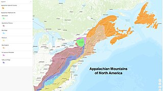
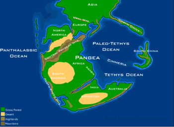
The geology of the Appalachians dates back more than 1.2 billion years to the Mesoproterozoic era when two continental cratons collided to form the supercontinent Rodinia, 500 million years prior to the development of the range during the formation of Pangea. The rocks exposed in today's Appalachian Mountains reveal elongate belts of folded and thrust faulted marine sedimentary rocks, volcanic rocks, and slivers of ancient ocean floor—strong evidences that these rocks were deformed during plate collision. The birth of the Appalachian ranges marks the first of several mountain building plate collisions that culminated in the construction of Pangea with the Appalachians and neighboring Anti-Atlas mountains near the center. These mountain ranges likely once reached elevations similar to those of the Alps and the Rocky Mountains before they were eroded.

The Grenville orogeny was a long-lived Mesoproterozoic mountain-building event associated with the assembly of the supercontinent Rodinia. Its record is a prominent orogenic belt which spans a significant portion of the North American continent, from Labrador to Mexico, as well as to Scotland.
The Hunter-Bowen Orogeny was a significant arc accretion event in the Permian and Triassic periods affecting approximately 2,500 km of the Australian continental margin.

The Petermann Orogeny was an Australian intracontinental event that affected basement rocks of the northern Musgrave Province and Ediacaran (Proterozoic) sediments of the (now) southern Amadeus Basin between ~550-535 Ma. The remains are seen today in the Petermann Ranges.

The Gascoyne Complex is a terrane of Proterozoic granite and metamorphic rock in the central-western part of Western Australia. The complex outcrops at the exposed western end of the Capricorn Orogen, a 1,000 km-long arcuate belt of folded, faulted and metamorphosed rocks between two Archean cratons; the Pilbara craton to the north and the Yilgarn craton to the south. The Gascoyne Complex is thought to record the collision of these two different Archean continental fragments during the Capricorn Orogeny at 1830–1780 Ma.

The Molasse basin is a foreland basin north of the Alps which formed during the Oligocene and Miocene epochs. The basin formed as a result of the flexure of the European plate under the weight of the orogenic wedge of the Alps that was forming to the south.

A foreland basin is a structural basin that develops adjacent and parallel to a mountain belt. Foreland basins form because the immense mass created by crustal thickening associated with the evolution of a mountain belt causes the lithosphere to bend, by a process known as lithospheric flexure. The width and depth of the foreland basin is determined by the flexural rigidity of the underlying lithosphere, and the characteristics of the mountain belt. The foreland basin receives sediment that is eroded off the adjacent mountain belt, filling with thick sedimentary successions that thin away from the mountain belt. Foreland basins represent an endmember basin type, the other being rift basins. Space for sediments is provided by loading and downflexure to form foreland basins, in contrast to rift basins, where accommodation space is generated by lithospheric extension.
The Lachlan Fold Belt (LFB) or Lachlan Orogen is a geological subdivision of the east part of Australia. It is a zone of folded and faulted rocks of similar age. It dominates New South Wales and Victoria, also extending into Tasmania, the Australian Capital Territory and Queensland. It was formed in the Middle Paleozoic from 450 to 340 Mya. It was earlier known as Lachlan Geosyncline. It covers an area of 200,000 km2.

A fold and thrust belt (FTB) is a series of mountainous foothills adjacent to an orogenic belt, which forms due to contractional tectonics. Fold and thrust belts commonly form in the forelands adjacent to major orogens as deformation propagates outwards. Fold and thrust belts usually comprise both folds and thrust faults, commonly interrelated. They are commonly also known as thrust-and-fold belts, or simply thrust-fold belts.

The Rhenohercynian Zone or Rheno-Hercynian zone in structural geology describes a fold belt of west and central Europe, formed during the Hercynian orogeny. The zone consists of folded and thrust Devonian and early Carboniferous sedimentary rocks that were deposited in a back-arc basin along the southern margin of the then existing paleocontinent Laurussia.

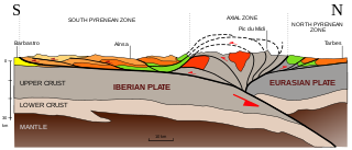
The Pyrenees are a 430-kilometre-long, roughly east–west striking, intracontinental mountain chain that divide France, Spain, and Andorra. The belt has an extended, polycyclic geological evolution dating back to the Precambrian. The chain's present configuration is due to the collision between the microcontinent Iberia and the southwestern promontory of the European Plate. The two continents were approaching each other since the onset of the Upper Cretaceous (Albian/Cenomanian) about 100 million years ago and were consequently colliding during the Paleogene (Eocene/Oligocene) 55 to 25 million years ago. After its uplift, the chain experienced intense erosion and isostatic readjustments. A cross-section through the chain shows an asymmetric flower-like structure with steeper dips on the French side. The Pyrenees are not solely the result of compressional forces, but also show an important sinistral shearing.

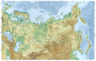
The geology of Russia, the world's largest country, which extends over much of northern Eurasia, consists of several stable cratons and sedimentary platforms bounded by orogenic (mountain) belts.

The geology of Queensland can be subdivided into several regions with different histories. Along the east coast is a complex of Palaezoic to Cainozoic rocks while much of the rest of the state is covered by Cretaceous and Cainozoic rocks. A Precambrian basement is found in the north west and Cape York regions. The Thomson Orogen occurs in the central and southern parts of Queensland, but is mostly covered by younger basins.

The East Antarctic Shield or Craton is a cratonic rock body that covers 10.2 million square kilometers or roughly 73% of the continent of Antarctica. The shield is almost entirely buried by the East Antarctic Ice Sheet that has an average thickness of 2200 meters but reaches up to 4700 meters in some locations. East Antarctica is separated from West Antarctica by the 100–300 kilometer wide Transantarctic Mountains, which span nearly 3,500 kilometers from the Weddell Sea to the Ross Sea. The East Antarctic Shield is then divided into an extensive central craton that occupies most of the continental interior and various other marginal cratons that are exposed along the coast.

The Gondwanide orogeny was an orogeny active in the Permian that affected parts of Gondwana that are by current geography now located in southern South America, South Africa, Antarctica, Australia and New Guinea. The zone of deformation in Argentina extends as a belt south and west of the cratonic nucleus of Río de la Plata–Pampia. The deformation of the orogeny is visible in the Sierra de la Ventana mountains in Argentina and the Cape Fold Belt in South Africa. The Gondwanide orogeny might have been linked with the roughly contemporary San Rafael orogeny of western Argentina.

The Marañón fold and thrust belt is a 1,000 kilometres (620 mi) long, northwest–southeast trending belt of deformed rocks located in the Andes of central Peru. The formation of the belt defines the Incaic Phase of the Andean orogeny.
The geology of Sicily records the collision of the Eurasian and the African plates during westward-dipping subduction of the African slab since late Oligocene. Major tectonic units are the Hyblean foreland, the Gela foredeep, the Apenninic-Maghrebian orogen, and the Calabrian Arc. The orogen represents a fold-thrust belt that folds Mesozoic carbonates, while a major volcanic unit is found in an eastern portion of the island. The collision of Africa and Eurasia is a retreating subduction system, such that the descending Africa is falling away from Eurasia, and Eurasia extends and fills the space as the African plate falls into the mantle, resulting in volcanic activity in Sicily and the formation of Tyrrhenian slab to the north.
The geology of Guinea-Bissau is oldest in the east and becomes younger toward the west, with sediments from the past 66 million years nearer the coast. Some rock units in the northeast are as much as 680 million years old and throughout the geologic past Guinea-Bissau was influenced by the Mauritanide Belt orogeny and was submerged or partially submerged as a marine shelf or river delta for most of its existence.
The geology of Mauritania is built on more than two billion year old Archean crystalline basement rock in the Reguibat Shield of the West African Craton, a section of ancient and stable continental crust. Mobile belts and the large Taoudeni Basin formed and filled with sediments in the connection with the Pan-African orogeny mountain building event 600 million years ago and a subsequent orogeny created the Mauritanide Belt. In the last 251 million years, Mauritania has accumulated additional sedimentary rocks during periods of marine transgression and sea level retreat. The arid country is 50% covered in sand dunes and has extensive mineral resources, although iron plays the most important role in the economy.


