Related Research Articles
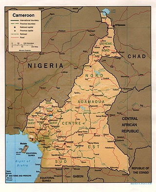
At 475,440 km2 (183,570 sq mi), Cameroon is the world's 53rd largest country. It is slightly larger than the nation of Sweden and the US state of California. It is comparable in size to Papua New Guinea. Cameroon's landmass is 472,710 km2 (182,510 sq mi), with 2,730 km2 (1,050 sq mi) of water.

Lake Nyos is a crater lake in the Northwest Region of Cameroon, located about 315 km (196 mi) northwest of Yaoundé, the capital. Nyos is a deep lake high on the flank of an inactive volcano in the Oku volcanic plain along the Cameroon line of volcanic activity. A volcanic dam impounds the lake waters.
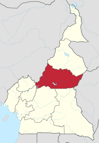
The Adamawa Region is a constituent region of the Republic of Cameroon. It borders the Centre and East regions to the south, the Northwest and West regions to the southwest, Nigeria to the west, the Central African Republic (CAR) to the east, and the North Region to the north.
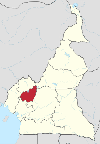
The West Region is 14,000 km2 of territory located in the central-western portion of the Republic of Cameroon. It borders the Northwest Region to the northwest, the Adamawa Region to the northeast, the Centre Region to the southeast, the Littoral Region to the southwest, and the Southwest Region to the west. The West Region is the smallest of Cameroon's ten regions in area, yet it has the highest population density.

The Cameroon line is a 1,600 km (1,000 mi) long chain of volcanoes that includes islands in the Gulf of Guinea and mountains on the African mainland, from Mount Cameroon on the coast towards Lake Chad on the northeast. They form a natural border between eastern Nigeria and the West Region of Cameroon. The islands, which span the equator, have tropical climates and are home to many unique plant and bird species. The mainland mountain regions are much cooler than the surrounding lowlands, and also contain unique and ecologically important environments.

The Jemez Lineament is a chain of late Cenozoic volcanic fields, 800 kilometers (500 mi) long, reaching from the Springerville and White Mountains volcanic fields in East-Central Arizona to the Raton-Clayton volcanic field in Northeastern New Mexico.

The Olympic–Wallowa lineament (OWL) is a series of geologic structures oriented from northwest to southeast for 650 km (400 mi) across Washington and northeast Oregon in the United States, passing through the Seattle area and including notable features east of the Cascade Range such as the Yakima Fold Belt and Wallowa Mountains. It was first reported by cartographer Erwin Raisz in 1945 on a relief map of the continental United States. Some geologists have questioned the existence of a geological relationship between the individual structures along the lineament suggesting it is an optical illusion. The origin of this feature in its entirety is not well understood with multiple hypotheses on the subject. The Olympic–Wallowa lineament likely predates the Columbia River Basalt Group.

The Brothers Fault Zone (BFZ) is the most notable of a set of northwest-trending fault zones including the Eugene–Denio, McLoughlin, and Vale zones that dominate the geological structure of most of Oregon. These are also representative of a regional pattern of generally northwest-striking geological features ranging from Walker Lane on the California–Nevada border to the Olympic–Wallowa Lineament in Washington; these are generally associated with the regional extension and faulting of the Basin and Range Province, of which the BFZ is considered the northern boundary.

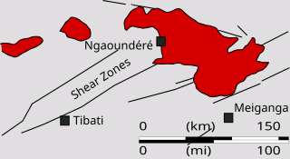
The Central African Shear Zone (CASZ) is a wrench fault system extending in an ENE direction from the Gulf of Guinea through Cameroon into Sudan. The structure is not well understood. As of 2008, there was still no general agreement about how the individual shears along the lineament link up.
The Benue Trough is a major geological structure underlying a large part of Nigeria and extending about 1,000 km northeast from the Bight of Benin to Lake Chad. It is part of the broader West and Central African Rift System.
The Trans Brazilian Lineament (TBL), or Transbrasiliano Lineament, is a major shear zone that developed in the Precambrian period, and that has been reactivated several times since then, mostly recently during the Mesozoic. Movement along the shear zone helps explain how the South American continent could have fitted tightly to the African continent before the breakup of Gondwana.
The Pharusian Ocean is an ancient ocean that existed from 800 to 635 million years ago, between the break-up of the Rodinia supercontinent and the start of formation of the Gondwana supercontinent.
The Kandi fault zone is a southern extension of the Hoggar fault zone in West Africa, with splays in Benin, Togo and southeastern Ghana. It lies at the southern end of the Trans Saharan belt, a lineament that extends in a southwest direction from Algeria to Benin. The Kandi fault zone is identified with the Sobral fault in northeastern Brazil, considered to be the northern section of the Trans Brazilian Lineament.
The Sobral fault is a major fault in the Borborema geological province of northeastern Brazil, a part of the Transbrasiliano lineament. It is commonly correlated with the Kandi fault in Benin, east of the West African craton. The fault lies in the northwest of Ceará state. It appears to have formed late in the orogeny when the West African craton engaged with the Congo craton, and to have allowed significant dextral strike-slip movement. It was reactivated when South America was breaking away from Africa. In this later phase, a sinistral shear movement of about 100 km seems to have taken place during and after the break-up.
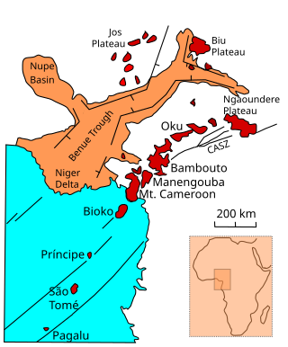
The Oku Volcanic Field or Oku Massif is a group of volcanoes based on a swell in the Cameroon Volcanic Line, located in the Oku region of the Western High Plateau of Cameroon. The Mount Oku stratovolcano rises to 3,011 m above sea level.
The Ngaoundéré Plateau is a highland area in the Adamawa Region of Cameroon. It contains Tchabal Nganha, a large volcano, and many other recent volcanic structures.
The Pernambuco Fault or Pernambuco Shear Zone in northeastern Brazil is a fault radiating from the Trans Brazilian Lineament eastwards to the coast, a major geological feature.
Tchabal Nganha is a stratovolcano on the Ngaoundere Plateau, a highland area in the Adamawa Region of Cameroon.
The geology of Cameroon is almost universally Precambrian metamorphic and igneous basement rock, formed in the Archean as part of the Congo Craton and the Central African Mobile Zone and covered in laterite, recent sediments and soils. Some parts of the country have sequences of sedimentary rocks from the Paleozoic, Mesozoic and Cenozoic as well as volcanic rock produced by the 1600 kilometer Cameroon Volcanic Line, which includes the still-active Mount Cameroon. The country is notable for gold, diamonds and some onshore and offshore oil and gas.
The geology of Brazil includes very ancient craton basement rock from the Precambrian overlain by sedimentary rocks and intruded by igneous activity, as well as impacted by the rifting of the Atlantic Ocean.
References
- ↑ J D Fairhead; Nasreddine Bournas; M Chaker Raddadi (2007). "The Role of Gravity and Aeromagnetic Data in Mapping Mega Gondwana Crustal Lineaments: the Argentina - Brazil – Algeria (ABA) Lineament" (PDF). SEG. Archived from the original (PDF) on 2011-07-11. Retrieved 2011-01-30.
- ↑ C. Dorbath; L. Dorbath; D. Fairhead; G. W. Stuart (1986). "A teleseismic delay time study across the Central African Shear Zone in the Adamawa region of Cameroon, West Africa" (PDF). Geophys. J. R. astr. Soc. pp. 751–766. Archived from the original (PDF) on 2011-08-07. Retrieved 2011-01-31.
- ↑ G. W. STUART; J.D. FAIRHEAD; L. DORBATH; C. DORBATH (1985). "CRUSTAL STRUCTURE OF THE ADAMAWA PLATEAU CAMEROON" (PDF). Revue Sciences et Techniques, Série Sciences de la Terre. Retrieved 2011-01-31.
- ↑ "Quake may have triggered Nyos disaster". New Scientist. 12 Feb 1987. Retrieved 2011-01-31.[ permanent dead link ]
6°37′0″N12°52′0″E / 6.61667°N 12.86667°E
| | This palaeogeography article is a stub. You can help Wikipedia by expanding it. |