
The Alps form part of a Cenozoic orogenic belt of mountain chains, called the Alpide belt, that stretches through southern Europe and Asia from the Atlantic all the way to the Himalayas. This belt of mountain chains was formed during the Alpine orogeny. A gap in these mountain chains in central Europe separates the Alps from the Carpathians to the east. Orogeny took place continuously and tectonic subsidence has produced the gaps in between.

The Arabian-Nubian Shield (ANS) is an exposure of Precambrian crystalline rocks on the flanks of the Red Sea. The crystalline rocks are mostly Neoproterozoic in age. Geographically – and from north to south – the ANS includes parts of Israel, Jordan, Egypt, Saudi Arabia, Sudan, Eritrea, Ethiopia, Yemen, and Somalia. The ANS in the north is exposed as part of the Sahara Desert and Arabian Desert, and in the south in the Ethiopian Highlands, Asir province of Arabia and Yemen Highlands.

Cimmeria was an ancient continent, or, rather, a string of microcontinents or terranes, that rifted from Gondwana in the Southern Hemisphere and was accreted to Eurasia in the Northern Hemisphere. It consisted of parts of present-day Turkey, Iran, Afghanistan, Pakistan, Tibet, China, Myanmar, Thailand, and Malaysia. Cimmeria rifted from the Gondwanan shores of the Paleo-Tethys Ocean during the Early Permian and as the Neo-Tethys Ocean opened behind it, during the Permian, the Paleo-Tethys closed in front of it. Because the different chunks of Cimmeria drifted northward at different rates, a Meso-Tethys Ocean formed between the different fragments during the Cisuralian. Cimmeria rifted off Gondwana from east to west, from Australia to the eastern Mediterranean. It stretched across several latitudes and spanned a wide range of climatic zones.
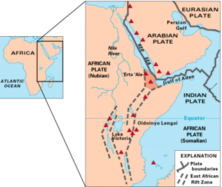
The Afar Triple Junction is located along a divergent plate boundary dividing the Nubian, Somali, and Arabian plates. This area is considered a present-day example of continental rifting leading to seafloor spreading and producing an oceanic basin. Here, the Red Sea Rift meets the Aden Ridge and the East African Rift. The latter extends a total of 6,500 kilometers (4,000 mi) from the Afar Triangle to Mozambique.

The Iberian Plate with the microcontinent Iberia encompassed not only the Iberian Peninsula but also Corsica, Sardinia, the Balearic Islands, and the Briançonnais zone of the Penninic nappes of the Alps. The Iberian plate is a part of the Eurasian plate.

The Blue Nile Basin is a major geological structure in the northwestern Ethiopian Plateau formed in the Mesozoic Era during a period of crustal extension associated with the break-up of Gondwana, and filled with sedimentary deposits. The modern Blue Nile river cuts across part of the sedimentary basin.
The White Nile rift is one of several rifts in central Sudan running in a NW direction and terminating in the Central African Shear Zone. The rift is a Cretaceous/Tertiary structure that has similar tectonic characteristics to the Southern Sudan Rift, Blue Nile rift and Atbara rift. These rifts follow similar trends, and terminate in a line at their northwestern ends. Probably this line is an extension of the Central African Shear Zone through the Sudan.
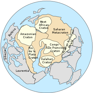
The Saharan Metacraton is a term used by some geologists to describe a large area of continental crust in the north-central part of Africa. Whereas a craton is an old and stable part of the lithosphere, the term "metacraton" is used to describe a craton that has been remobilized during an orogenic event, but where the characteristics of the original craton are still identifiable. The geology of the continent has only been partially explored, and other names have been used to describe the general area that reflect different views of its nature and extent. These include "Nile Craton", "Sahara Congo Craton", "Eastern Saharan Craton" and "Central Saharan Ghost Craton". This last term is because the older rocks are almost completely covered by recent sediments and desert sands, making geological analysis difficult.

The Central African Shear Zone (CASZ) is a wrench fault system extending in an ENE direction from the Gulf of Guinea through Cameroon into Sudan. The structure is not well understood. As of 2008, there was still no general agreement about how the individual shears along the lineament link up.
The Benue Trough is a major geological structure underlying a large part of Nigeria and extending about 1,000 km northeast from the Bight of Benin to Lake Chad. It is part of the broader West and Central African Rift System.
The South China Sea Basin is one of the largest marginal basins in Asia. South China Sea is located to the east of Vietnam, west of Philippines and the Luzon Strait, and north of Borneo. Tectonically, it is surrounded by the Indochina Block on the west, Philippine Sea Plate on the east, Yangtze Block to the north. A subduction boundary exists between the Philippine Sea Plate and the Asian Plate. The formation of the South China Sea Basin was closely related with the collision between the Indian Plate and Eurasian Plates. The collision thickened the continental crust and changed the elevation of the topography from the Himalayan orogenic zone to the South China Sea, especially around the Tibetan Plateau. The location of the South China Sea makes it a product of several tectonic events. All the plates around the South China Sea Basin underwent clockwise rotation, subduction and experienced an extrusion process from the early Cenozoic to the Late Miocene.

The North Sea is part of the Atlantic Ocean in northern Europe. It is located between Norway and Denmark in the east, Scotland and England in the west, Germany, the Netherlands, Belgium and France in the south.

The North German Basin is a passive-active rift basin located in central and west Europe, lying within the southeasternmost portions of the North Sea and the southwestern Baltic Sea and across terrestrial portions of northern Germany, Netherlands, and Poland. The North German Basin is a sub-basin of the Southern Permian Basin, that accounts for a composite of intra-continental basins composed of Permian to Cenozoic sediments, which have accumulated to thicknesses around 10–12 kilometres (6–7.5 mi). The complex evolution of the basin takes place from the Permian to the Cenozoic, and is largely influenced by multiple stages of rifting, subsidence, and salt tectonic events. The North German Basin also accounts for a significant amount of Western Europe's natural gas resources, including one of the world's largest natural gas reservoir, the Groningen gas field.
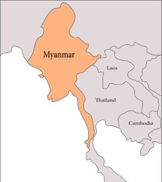
The geology of Myanmar is shaped by dramatic, ongoing tectonic processes controlled by shifting tectonic components as the Indian plate slides northwards and towards Southeast Asia. Myanmar spans across parts of three tectonic plates separated by north-trending faults. To the west, a highly oblique subduction zone separates the offshore Indian plate from the Burma microplate, which underlies most of the country. In the center-east of Myanmar, a right lateral strike slip fault extends from south to north across more than 1,000 km (620 mi). These tectonic zones are responsible for large earthquakes in the region. The India-Eurasia plate collision which initiated in the Eocene provides the last geological pieces of Myanmar, and thus Myanmar preserves a more extensive Cenozoic geological record as compared to records of the Mesozoic and Paleozoic eras. Myanmar is physiographically divided into three regions: the Indo-Burman Range, Myanmar Central Belt and the Shan Plateau; these all display an arcuate shape bulging westwards. The varying regional tectonic settings of Myanmar not only give rise to disparate regional features, but they also foster the formation of petroleum basins and a diverse mix of mineral resources.

Hainan Island, located in the South China Sea off the Chinese coast and separated from mainland China by the Qiongzhou Strait, has a complex geological history that it has experienced multiple stages of metamorphism, volcanic and intrusive activities, tectonic drifting and more. The oldest rocks, the Proterozoic metamorphic basement, are not widely exposed, but mostly found in the western part of the Island.
Guyana occurs within the northern part of the Guiana Shield. The Guiana Shield forms the northern part of the Amazonian Craton, the core of the South American continent.

The Wessex Basin is a petroleum-bearing geological area located along the southern coast of England and extending into the English Channel. The onshore part of the basin covers approximately 20,000 km2 and the area that encompasses the English Channel is of similar size. The basin is a rift basin that was created during the Permian to early Cretaceous in response to movement of the African plate relative to the Eurasian plate. In the late Cretaceous, and again in the Cenozoic, the basin was inverted as a distant effect of the Alpine orogeny. The basin is usually divided into 3 main sub-basins including the Winterborne-Kingston Trough, Channel Basin, and Vale of Pewsey Basin. The area is also rich in hydrocarbons with several offshore wells in the area. With the large interest in the hydrocarbon exploration of the area, data became more readily available, which improved the understanding of the type of inversion tectonics that characterize this basin.
The geology of Brazil includes very ancient craton basement rock from the Precambrian overlain by sedimentary rocks and intruded by igneous activity, as well as impacted by the rifting of the Atlantic Ocean.

The Ordos Block is a crustal block, that forms part of the larger North China Block (NCB). It is surrounded by active fault systems and has been a distinct block since at least the Mesozoic. It is bordered to the west by the Alxa Block, the westernmost part of the NCB, to the south by the Qinling orogenic belt, to the north by the Yanshan-Yinshan orogenic belt, part of the Central Asian Orogenic Belt and to the east by the Taihangshan mountain range, which forms part of the Trans-North China Orogen. The block is currently stable and large earthquakes are restricted to the bordering fault zones. It has been suggested that the block is currently undergoing anti-clockwise rotation with respect to the Eurasian Plate, as a result of the ongoing eastward spreading of the Tibetan Plateau, although this view has been challenged.

