Benin, a narrow, key-shaped, north–south strip of land in West Africa, lies between the Equator and the Tropic of Cancer. Its latitude ranges from 6°30′ N to 12°30′ N and its longitude from 1° E to 3°40′ E. It is bounded by Togo to the west, Burkina Faso and Niger to the north, Nigeria to the east, and the Bight of Benin to the south.

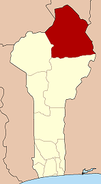
Alibori is the largest and northernmost department of Benin. Externally the department borders the countries of Burkina Faso, Niger, and Nigeria, and internally the departments of Atakora and Borgou. The department of Alibori was created in 1999 when it was split off from Borgou Department and is named after the Alibori River.

Dosso is a city in the south-west corner of Niger. It lies 130–140 kilometres (81–87 mi) south-east of the capital Niamey at the junction of the main routes to Zinder and Benin. The eighth-most populous town in Niger and the largest in Dosso Region, it had an official population during the 2001 census of 43,561. The population grew to 58,671 in the 2012 census. It is the capital of its region - which covers five departments in the southwestern corner of the nation - as well as of its own department, Dosso Department. The city itself lies at the centre of its own Urban Commune.
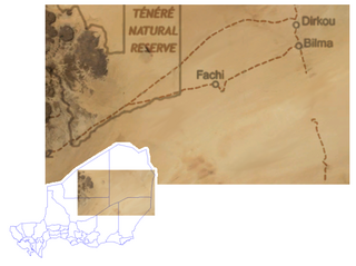
Bilma is an oasis town and commune in north east Niger with, as of the 2012 census, a total population of 4,016 people. It lies protected from the desert dunes under the Kaouar Cliffs and is the largest town along the Kaouar escarpment. It is known for its gardens, for salt and natron production through evaporation ponds, date cultivation, and as the destination of one of the last Saharan caravan routes.

Bohicon or Gbɔ̀xikɔn is a city in Benin, and a conurbation of Abomey lying 9 kilometres east of the city on the railway line from Cotonou to Parakou and on Benin's main highway RNIE 2 which joins the RNIE 4. The commune covers an area of 139 square kilometres and as of 2012 had a population of 149,271 people.
Malanville is a city, arrondissement and commune in the Alibori Department of northeastern Benin, located across the River Niger from Niger. It is known as a centre of cross-border trade and has a major market. Malanville is also a centre for rice-growing. The commune covers an area of 3016 square kilometres and as of 2013 had a population of 168,006 people.
Boukoumbé or Boukombé is a town, arrondissement and commune in north western Benin on the border with Togo. It is known for its market, its whipping ceremony and for its tradition of pipe making. Mount Kousso-Kovangou, the highest point in Benin, lies nearby.

Bassila is a town, arrondissement, and commune located in the Donga Department of Benin. The commune covers an area of 120 square kilometres and as of 2013 had a population of 130,770 people.
Nikki is a town, arrondissement, and commune located in the Borgou Department of Benin. The commune covers an area of 3171 square kilometres and as of 2002 had a population of 99,251 people.
Ségbana is a town, arrondissement and commune located in the Alibori Department of Benin. The commune covers an area of 4471 square kilometres and as of 2013 had a population of 89,268 people.
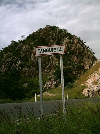
Tanguiéta is a town, arrondissement and commune located in the Atakora Department of Benin.The commune covers an area of 5465 square kilometres and as of 2013 had a population of 74,675 people. As of 2007 the town had an estimated population of 21,290. It lies on the RNIE 3 highway which connects it to Natitingou.
N'Dali is a city and arrondissement in the north of Benin, and the capital of the Commune of N'Dali in the Borgou Department. The commune covers an area of 3748 square kilometres and as of 2013 had a population of 113,604 people. In 2008 an estimated 16,941 people living in the main town of N'Dali.
Agbangnizoun is a town, arrondissement, and commune in the Zou Department of south-western Benin. The town lies 20 kilometres south-east of Abomey. The commune covers an area of 244 square kilometres and as of 2002 had a population of 55,001 people.
Djidja is a town, arrondissement, and commune in the Zou Department of south-western Benin. The commune covers an area of 2184 square kilometres and as of 2013 had a population of 123,542 people.
Birni-Lafia or Birni Lafia is a town and arrondissement in the Alibori Department of northeastern Benin. It is an administrative division under the jurisdiction of the commune of Karimama. According to the population census conducted by the Institut National de la Statistique Benin on February 15, 2002, the arrondissement had a total population of 9,946.
Bogo-Bogo is a town and arrondissement in the Alibori Department of northeastern Benin. It is an administrative division under the jurisdiction of the commune of Karimama. According to the population census conducted by the Institut National de la Statistique Benin on February 15, 2002, the arrondissement had a total population of 7,134.
Kompa is a town and arrondissement in the Alibori Department of northeastern Benin. It is an administrative division under the jurisdiction of the commune of Karimama. According to the population census conducted by the Institut National de la Statistique Benin on February 15, 2002, the arrondissement had a total population of 7,119.
Monsey is a town and arrondissement in the Alibori Department of northeastern Benin. It is an administrative division under the jurisdiction of the commune of Karimama. According to the population census conducted by the Institut National de la Statistique Benin on February 15, 2002, the arrondissement had a total population of 7,605.
Tchianhoun-Cossi is a town and arrondissement in the Atakora Department of northwestern Benin. It is an administrative division under the jurisdiction of the commune of Matéri. According to the population census conducted by the Institut National de la Statistique Benin on February 15, 2002, the arrondissement had a total population of 16,625.

Kandi is a town, arrondissement and commune in the Alibori Department of eastern Benin. Originally a market town, Kandi is now primarily a farming centre. It lies on the nation's main north-south highway, 650 km (400 mi) from Cotonou and 523 km (325 mi) north of Porto-Novo. The town is the capital of the department of Alibori. The commune covers an area of 3,421 km2 (1,321 sq mi) and as of 2013 had a population of 177,683 people. The town itself had a population of 27,227 in 2002.