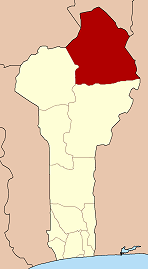
Alibori is the largest and northernmost department of Benin. Externally the department borders the countries of Burkina Faso, Niger, and Nigeria, and internally the departments of Atakora and Borgou. The department of Alibori was created in 1999 when it was split off from Borgou Department and is named after the Alibori River.
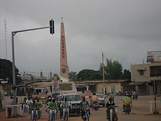
Parakou is the largest city in northern Benin, with an estimated population of around 206,667 people, and capital of the Borgou Department. Administratively the commune of Parakou makes up one of Benin's 77 communes. Since 2015, its mayor is Souradjou Adamou Karimou.
Boukoumbé or Boukombé is a town, arrondissement and commune in north western Benin on the border with Togo. It is known for its market, its whipping ceremony and for its tradition of pipe making. Mount Kousso-Kovangou, the highest point in Benin, lies nearby.
An administrative center is a seat of regional administration or local government, or a county town, or the place where the central administration of a commune is located.

Gaya is a city in the Gaya Department of the Dosso Region of Niger. The city is situated 254 km southeast of the capital, Niamey, is located on the banks of the Niger River, and is near the borders with Benin and Nigeria. Gaya has a population of 28,385. The wettest area in Niger, Gaya averages 800 mm in rainfall a year.

Abomey-Calavi is a city, arrondissement, and commune located in the Atlantique Department of Benin. It is now essentially a suburb of Cotonou and at its closest it begins approximately 18 km from the city centre of Cotonou. The main cities of the commune are Abomey-Calavi itself and Godomey to the south. The commune covers an area of 650 square kilometres and as at the May 2013 Census had a population of 655,965 people. Projected to be the eleventh fastest growing city on the African continent between 2020 and 2025, with a 5.27% growth.
Banikoara is a town, arrondissement and commune located in the Alibori Department of Benin. It lies 69 kilometers west of Kandi at the heart of the most productive cotton-growing region in Benin. Its name is a Europeanized version of a Bariba phrase meaning "Bani's town," and honors its founder, Bani Gansé.
Cové is a city in the Zou Department of Benin. The commune covers an area of 525 square kilometres and as of 2012 had a population of 43,554 people.
Ségbana is a town, arrondissement and commune located in the Alibori Department of Benin. The commune covers an area of 4471 square kilometres and as of 2013 had a population of 89,268 people.
Karimama is a town, arrondissement and commune in the Alibori Department of northeastern Benin. The commune covers an area of 6102 square kilometers and as of 2013 had a population of 66,675 people. The town lies on the border with Niger.
Adjohoun or Adjohon is a town, arrondissement, and commune in Ouémé Department, Benin. The commune is divided into 8 arrondissements and 57 villages. The commune of Adjohoun is located approximately 32 km from Porto-Novo and 62 km from Cotonou. The commune covers an area of 308 km2 and as of 2002 had a population of 60,955, 48.14% male and 51.86% female. The commune covers an area of 112 square kilometres and as of 2002 had a population of 60,112 people.
N'Dali is a city and arrondissement in the north of Benin, and the capital of the Commune of N'Dali in the Borgou Department. The commune covers an area of 3748 square kilometres and as of 2013 had a population of 113,604 people. In 2008 there were an estimated 16,941 people living in the main town of N'Dali.
The following outline is provided as an overview of and topical guide to Benin:
Cobly or Kobli is a town, arrondissement and commune in the Atakora Department of north-western Benin.
Djidja is a town, arrondissement, and commune in the Zou Department of south-western Benin. The commune covers an area of 2184 square kilometres and as of 2013 had a population of 123,542 people.
Zogbodomey or Zogbodomè is a town, arrondissement, and commune in the Zou Department of south-western Benin. The commune covers an area of 600 square kilometres and as of 2002 had a population of 72,338 people.
Madécali is an arrondissement in the Alibori Department of northeastern Benin. It is an administrative division under the jurisdiction of the commune of Malanville. According to the population census conducted by the Institut National de la Statistique Benin on February 15, 2002, the arrondissement had a total population of 14,105.

Kandi is a town, arrondissement and commune in the Alibori Department of eastern Benin. Originally a market town, Kandi is now primarily a farming centre. It lies on the nation's main north-south highway, 650 km (400 mi) from Cotonou and 523 km (325 mi) north of Porto-Novo. The town is the capital of the department of Alibori. The commune covers an area of 3,421 km2 (1,321 sq mi) and as of 2013 had a population of 177,683 people. The town itself had a population of 27,227 in 2002.

The National Centre of Management of Fauna Reserves is an organization in Benin established on 2 April 1996. Its mission is to conserve and manage nature reserves, national parks, wildlife reserves, special reserves and their buffer zones. CENAGREF is active in the Pendjari National Park and the W National Park. CENAGREF reports to the Ministry of Environment and Nature Protection.

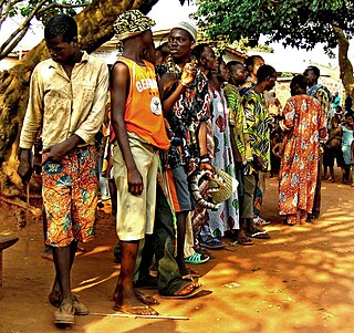
Fresh (wet) markets occur in most towns and villages in Benin, usually surrounded by large numbers of small shops selling foods, consumer items, imported foods and goods, clothing, household goods, etc. With a large portion of the population producing much of their own food, particularly for starches, open markets are where the diet is rounded out with items not self-produced. For those with higher incomes, more of the food consumed is purchased at market. Most vegetables are in villages and town markets, which usually have a major day, or multiple days, where traders and retailers are active in selling perishables in particular. Fish, meats, staple starch crops, legumes, soy and milk cheeses, fruits, and vegetables are available in the market every week of the year in most places with significant variations in the quantity supplied. Staple crops are usually sold to retailers by wholesalers, who obtain them from the producers. Meat is sold by the butchers who source from the producers. The source of vegetables depends on the season. Regional trade keeps a selection of vegetables available, with price and quantity fluctuations depending on the season. Visits to markets in the Parakou and Nikki areas observed avocados from Lomé in Togo and red onions from Niger. Eastern border markets have many Nigerian traders coming into Benin to purchase fruits and vegetables for sale in Nigeria. Most of these transactions are not captured in either of the countries' statistical records. Vegetables traders/retailers obtain their products either from the intermediary traders or directly at the farm gate if possible. For many items there are unwritten agreements that producers will sell to retailers, not directly to consumers. Intermediaries buy at the farms and transport the products directly to their various market destinations. Women dominate the role of vegetable retailers at these open markets. Vegetable producers market much of their produce in bulk at harvest time because of the highly perishable nature of their products. In general, producers conduct all of their sales immediately after harvest. The long marketing channel of vegetables in the larger peri-urban and urban areas involves several types of intermediaries, from local traders to wholesalers. Studies by INRAB have shown that producers are more inefficient in marketing than in production. There is a lack of market participation of farmers and current barriers to entry by farmers limit their access to markets.