The Sheffield and South Yorkshire Navigation (S&SY) is a system of navigable inland waterways in South Yorkshire and Lincolnshire, England.

Crowle is a market town in the civil parish of Crowle and Ealand, on the Isle of Axholme in the North Lincolnshire unitary authority of Lincolnshire, England. The civil parish had a population at the 2011 census of 4,828. The town lies on the Stainforth and Keadby Canal.

The Axholme Joint Railway was a committee created as a joint enterprise between the Lancashire and Yorkshire Railway (L&Y) and the North Eastern Railway (NER) and was established by the North Eastern Railway Act of 31 July 1902. It took over the Goole and Marshland Railway, running from Marshland Junction near Goole to Reedness Junction and Fockerby, and the Isle of Axholme Light Railway, running from Reedness Junction to Haxey Junction. Construction of the Goole and Marshland Railway had begun in 1898, and by the time of the takeover in early 1903, was virtually complete. The Isle of Axholme Light Railway was started in 1899, but only the section from Reedness Junction to Crowle was complete at the takeover. The northern section opened on 10 August 1903, and the line from Crowle to Haxey Junction opened for passengers on 2 January 1905.
The Isle of Axholme is an area of Lincolnshire, England, adjoining South Yorkshire and the East Riding of Yorkshire. It is located between Scunthorpe and Gainsborough, both of which are in the traditional West Riding of Lindsey, and Doncaster, in South Yorkshire.

Althorpe is a small village and former civil parish, now in the parish of Keadby with Althorpe, in the North Lincolnshire district, in the ceremonial county of Lincolnshire, England. It is four miles (6 km) west of Scunthorpe and the same distance south-east of Crowle, on the A18 road.
The New Junction Canal is a canal in South Yorkshire, England. It is part of the Sheffield and South Yorkshire Navigation (S&SYN), although it was jointly funded by the Aire and Calder Navigation and was opened in 1905. It links the River Don Navigation and the Stainforth and Keadby Canal with the Aire and Calder Navigation. It is straight and was the last canal built in England for commercial purposes.

Althorpe railway station serves the village of Althorpe in North Lincolnshire, England. The station is also very close to the villages of Keadby, Gunness and Burringham.

Amcotts is a village and civil parish in the North Lincolnshire district of Lincolnshire, England, and on the Isle of Axholme. The village is situated north-west from Scunthorpe, and on the west bank of the River Trent facing Flixborough on the east bank. The 2001 Census recorded a population of 219 for the parish, increasing to 262 at the 2011 census.
Hatfield Chase is a low-lying area in South Yorkshire and North Lincolnshire, England, which was often flooded. It was a royal hunting ground until Charles I appointed the Dutch engineer Cornelius Vermuyden to drain it in 1626. The work involved the re-routing of the Rivers Don, Idle, and Torne, and the construction of drainage channels. It was not wholly successful, but changed the whole nature of a wide swathe of land including the Isle of Axholme, and caused legal disputes for the rest of the century. The civil engineer John Smeaton looked at the problem of wintertime flooding in the 1760s, and some remedial work was carried out.

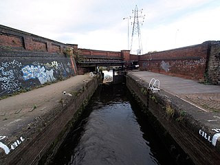
The Stainforth and Keadby Canal is a navigable canal in South Yorkshire and Lincolnshire, England. It connects the River Don Navigation at Bramwith to the River Trent at Keadby, by way of Stainforth, Thorne and Ealand, near Crowle. It opened in 1802, passed into the control of the River Don Navigation in 1849, and within a year was controlled by the first of several railway companies. It became part of the Sheffield and South Yorkshire Navigation, an attempt to remove several canals from railway control, in 1895. There were plans to upgrade it to take larger barges and to improve the port facilities at Keadby, but the completion of the New Junction Canal in 1905 made this unnecessary, as Goole could easily be reached and was already a thriving port.
Ealand is a small village in the civil parish of Crowle and Ealand, in the North Lincolnshire district, in the county of Lincolnshire, England. It is situated within the Isle of Axholme, 1 mile (1.6 km) south-east from Crowle, and 0.5 miles (0.8 km) north from the junction between the A161 and the A18 roads.
The original Keadby railway station was the easternmost terminus of the South Yorkshire Railway. The railway, which was extended from Thorne and opened in September 1859 was built without an Act of Parliament, as the railway company owned the canal alongside which they built the line.

Luddington is a village and former civil parish, now in the parish of Luddington with Haldenby, on the Isle of Axholme in the North Lincolnshire district, in the ceremonial county of Lincolnshire, England. The population of the civil parish of "Luddington with Haldenby" at the 2011 census was 419. It is 6 miles (10 km) north-west from Scunthorpe, 6 miles south-east from Goole and 18 miles (29 km) north-east from Doncaster.

Gunness is a village and civil parish in North Lincolnshire, England. It is situated 3 miles (5 km) west from Scunthorpe, and on the east bank of the River Trent. The population of the civil parish at the 2011 census was 2,462.
Eastoft is a village and civil parish in North Lincolnshire, England. It is situated within the Isle of Axholme, 3 miles (5 km) north-east from Crowle, and on the A161 road.

Garthorpe is a village in the North Lincolnshire, England. It is situated approximately 8 miles (13 km) south-east from Goole, 1 mile (1.6 km) west from the River Trent, and in the Isle of Axholme.

Scotter is a large village and civil parish in West Lindsey, Lincolnshire, England, situated between Scunthorpe and Gainsborough.
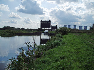
Keadby Bridge, more formally known as the King George V Bridge, crosses the River Trent near Althorpe and Keadby in Lincolnshire, England. It was designed by Alfred Charles Gardner FRSE MIME.

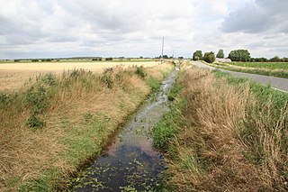
The River Torne is a river in the north of England, which flows through the counties of South Yorkshire and North Lincolnshire. It rises at the Upper Lake at Sandbeck Hall, in Maltby in South Yorkshire, and empties into the River Trent at Keadby pumping station. Much of the channel is engineered, as it plays a significant role in the drainage of Hatfield Chase, which it crosses.

The South Humberside Main Line runs from Doncaster on the East Coast Main Line to Thorne where it diverges from the Sheffield to Hull Line. It then runs eastwards to Scunthorpe and the Humber ports of Immingham and Grimsby, with the coastal resort of Cleethorpes as terminus.


