
Cape Town is a legislative capital of South Africa, colloquially named the Mother City. It is the legislative capital of South Africa and primate city of the Western Cape province. It forms part of the City of Cape Town metropolitan municipality.
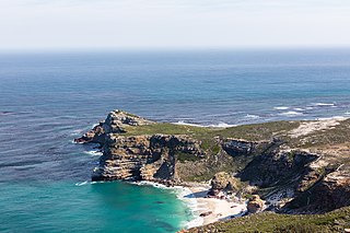
The Cape of Good Hope is a rocky headland on the Atlantic coast of the Cape Peninsula in South Africa.
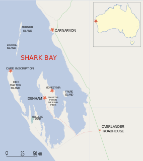
Dirk Hartog Island is an island off the Gascoyne coast of Western Australia, within the Shark Bay World Heritage Area. It is about 80 kilometres long and between 3 and 15 kilometres wide and is Western Australia's largest and most western island. It covers an area of 620 square kilometres and is approximately 850 kilometres north of Perth. It was named after Dirk Hartog, a Dutch sea captain, who first encountered the Western Australian coastline close to the 26th parallel south latitude, which runs through the island. After leaving the island, Hartog continued his voyage north-east along the mainland coast. Hartog gave the Australian mainland one of its earliest known names, as Eendrachtsland, which he named after his ship Eendracht, meaning "Unity".

Cape Bojador is a headland on the northern coast of Western Sahara, at 26° 07' 37"N, 14° 29' 57"W, as well as the name of the large nearby town with a population of 42,651. The name of the surrounding province also derives its name from the cape.

The Cobourg Peninsula is located 350 km east of Darwin in the Northern Territory, Australia. It is deeply indented with coves and bays, covers a land area of about 2,100 km², and is virtually uninhabited with a population ranging from about 20 to 30 in five family outstations, but without any notable settlement or village. It is separated from Croker Island in the east by Bowen Strait, which is 2.5 km wide in the south and up to 7 km in the north, and 8.5 km long. In the west, it is separated from Melville Island by Dundas Strait. From Cape Don, the western point of the peninsula, to Soldier Point in the east of Melville Island, the distance is 28 km. In the north is the Arafura Sea, and in the south the Van Diemen Gulf. The highest elevation is Mount Roe in the south with an altitude of 160 m.

The Cape Peninsula is a generally rocky peninsula that juts out into the Atlantic Ocean at the south-western extremity of the African continent. At the southern end of the peninsula are Cape Point and the Cape of Good Hope. On the northern end is Table Mountain, overlooking Cape Town, South Africa. The peninsula is 52 km long from Mouille point in the north to Cape Point in the south. The Peninsula has been an island on and off for the past 5 million years, as sea levels fell and rose with the ice age and interglacial global warming cycles of, particularly, the Pleistocene. The last time that the Peninsula was an island was about 1.5 million years ago. Soon afterwards it was joined to the mainland by the emergence from the sea of the sandy area now known as the Cape Flats. The towns and villages of the Cape Peninsula and Cape Flats now form part of the City of Cape Town Metropolitan Municipality.

The Cape Town Stadium in Cape Town, South Africa is a stadium that was built for the 2010 FIFA World Cup. During the planning stage, it was known as the Green Point Stadium, which was the name of the previous stadium on the site, and this name was also used frequently during World Cup media coverage. It is the home ground of Premier Soccer League clubs Ajax Cape Town and Cape Town City. It has also hosted the South Africa Sevens rugby tournament since 2015.

Cape Lopez is a headland on the coast of Gabon, west central Africa. The westernmost point of Gabon, it separates the Gulf of Guinea from the South Atlantic Ocean. Cape Lopez is the northernmost point of a low, wooded island between two mouths of the Ogooué River. There is an oil terminal at the southeast side of the cape, and the seaport of Port-Gentil lies about 10 km southeast of the cape. A lighthouse has existed on the Cape since 1897; the current tower was built in 1911, but has been inactive for many years and is in danger of collapsing from erosion.

The Endeavour Strait is a strait running between the Australian mainland Cape York Peninsula and Prince of Wales Island in the extreme south of the Torres Strait, in northern Queensland, Australia. It was named in 1770 by explorer James Cook, after his own vessel, HMS Endeavour, and he used the strait as passage out to the Indian Ocean on his voyage.

Birkenhead is a settlement in Overberg District Municipality in the Western Cape province of South Africa. It is located on the Danger Point Peninsula on the southern side of Walker Bay. It is in Ward 2 of Overstrand Local Municipality.
Franskraalstrand, also known as Franskraal, is a coastal village near to Gansbaai in the Western Cape province of South Africa. As of 2011 it had a population of 1,165 people in 592 households.

The borders of the oceans are the limits of the Earth's oceanic waters. The definition and number of oceans can vary depending on the adopted criteria.

The Lawrence Rocks are a group of two rocky islets, 6.8 ha and 1.5 ha in area, with an associated reef, 2.4 km south-east of Point Danger in western Victoria, Australia, and about 6 km south-east of the city of Portland. Geologically, the group is formed from the remnants of an extinct volcano, with the islets composed of basalt and tuff.
Dunoon is a small township situated in Milnerton, Cape Town, South Africa. The first erf for Dunoon was surveyed in 1996. As the formal housing was built, shacks mushroomed in the area.

In South Africa, as elsewhere in the world, the railways played a huge part in development and growth on nearly all terrains in the country. Conversely, events in South Africa and its neighbours over the years had a huge influence on the development of railways.

Tafelberg School is an English medium Grade 1–12 public school in Bothasig, Cape Town, South Africa which offers remedial activities for children with special learning needs. The school was located in Sea Point before mid–2010. As of 2014, the school accommodates its full capacity of 400 students.

Ellerslie Girls' High School was a girls' public high school at 355 Main Road, Sea Point, Cape Town, South Africa. The school was established in 1898. In 1989 the school merged with Sea Point High School, formerly Sea Point Boys' High School, which had become co-educational.

The Fox Islands Passes are waterways in the Fox Islands area of the U.S. state of Alaska, connecting the Bering Sea with the North Pacific Ocean.


