Wolvengat

Last updated
Wolvengat

Viljoenshof
South Africa Western Cape location map.svg
Red pog.svg
Wolvengat
South Africa adm location map.svg
Red pog.svg
Wolvengat
Coordinates: 34°40′12″S19°42′00″E / 34.6700°S 19.7000°E / -34.6700; 19.7000 Coordinates: 34°40′12″S19°42′00″E / 34.6700°S 19.7000°E / -34.6700; 19.7000
Country South Africa
Province Western Cape
District Overberg
Municipality Overstrand
Area
[1]
  Total1.36 km2 (0.53 sq mi)
Population
(2011) [1]
  Total50
  Density37/km2 (95/sq mi)
Racial makeup (2011)
[1]
   Black African 11.8%
   Coloured 41.2%
   White 43.1%
  Other3.9%
First languages (2011)
[1]
   Afrikaans 80.4%
   English 19.6%
Time zone UTC+2 (SAST)

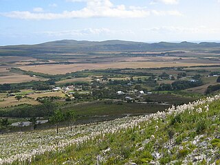
Wolvengat, also known as Viljoenshof, is a village in the southern Overberg region, in the Western Cape province of South Africa. It is situated 10 kilometres (6 mi) south of Elim and 35 kilometres (22 mi) southwest of Bredasdorp. It was originally named Wolfgat or Wolvengat in reference to the brown hyena, known as strandwolf in Afrikaans. [2] However, when the local post office was established the authorities named it Viljoenshof [3] in honour of DJ Viljoen, the Dutch Reformed (NGK) minister of Bredasdorp from 1904 to 1934; [4] this name was then extended to the village. The original name Wolvengat was officially restored in 1991. [5]

Overberg

Overberg is a region in South Africa to the east of Cape Town beyond the Hottentots-Holland mountains. It lies along the Western Cape Province's south coast between the Cape Peninsula and the region known as the Garden Route in the east. The boundaries of the Overberg are the Hottentots-Holland mountains in the West; the Riviersonderend Mountains, part of the Cape Fold Belt, in the North; the Atlantic and Indian Oceans in the South and the Breede River in the East.

Western Cape Province of South Africa on the south-western coast

The Western Cape is a province of South Africa, situated on the south-western coast of the country. It is the fourth largest of the nine provinces with an area of 129,449 square kilometres (49,981 sq mi), and the third most populous, with an estimated 6.6 million inhabitants in 2018. About two-thirds of these inhabitants live in the metropolitan area of Cape Town, which is also the provincial capital. The Western Cape was created in 1994 from part of the former Cape Province.

Elim, Western Cape Place in Western Cape, South Africa

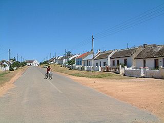
Elim is a village on the Agulhas Plain in the Western Cape of South Africa. It was established in 1824 by German missionaries as a Moravian mission station. When selecting the location, the missionaries placed a high priority on the proximity of water and on terrain that was suitable for planting vines so that wine for communion could be produced. As well as preaching the Gospel, the missionaries taught the villagers a variety of trades and skills. Elim's thatchers continue to be renowned for their craftsmanship.

In the early 1900s the village had a school with 100 children, but by the early 21st century there was neither a church nor a school. The fertile soil, and the potential of using land for vineyards, explains the high property prices. [3]

Related Research Articles

Cape Agulhas Local Municipality Local municipality in Western Cape, South Africa

Cape Agulhas Municipality is a municipality located in the Western Cape Province of South Africa. As of 2011 it had a population of 33,038. Its municipality code is WC033. It is named after Cape Agulhas, the southernmost point of Africa. The largest town is Bredasdorp, which is the seat of the municipal headquarters. It also includes the villages of Napier, Struisbaai, Elim, Arniston and L'Agulhas, and the De Hoop Nature Reserve.

Theewaterskloof Local Municipality Local municipality in Western Cape, South Africa

Theewaterskloof Municipality is a local municipality located within the Overberg District Municipality, in the Western Cape province of South Africa. As of 2007, the population was 108,790. Its municipality code is WC031. The enormous Theewaterskloof Dam, which provides water for Cape Town and the surrounding areas, is located in this municipality.

Umgeni River river in KwaZulu-Natal

The Umgeni River or Mgeni River, is a river in KwaZulu-Natal, South Africa. It rises in the "Dargle" in the KZN midlands, and its mouth is at Durban, some distance north of Durban's natural harbour. The name is taken to mean the river of entrance in Zulu, though other meanings have been proposed.

Overberg District Municipality District municipality in Western Cape, South Africa

The Overberg District Municipality is a district municipality that governs the Overberg region in the Western Cape province of South Africa. It is divided into four local municipalities and includes the major towns of Grabouw, Caledon, Hermanus, Bredasdorp and Swellendam. The municipal area covers 12,241 square kilometres (4,726 sq mi) and had in 2007 an estimated population of 212,787 people in 60,056 households.

Gansbaai Place in Western Cape, South Africa

Gansbaai is a fishing town and popular tourist destination in the Overberg District Municipality, Western Cape, South Africa. It is known for its dense population of great white sharks and as a whale-watching location.

Arniston, Western Cape Place in Western Cape, South Africa

Arniston is a small seaside settlement on the coast of the Overberg region of South Africa, close to Cape Agulhas, the southernmost tip of Africa. Prior to the wreck of Arniston, it is also known as Waenhuiskrans, an Afrikaans name meaning literally "Wagon house cliff", after a local sea cave large enough to accommodate a wagon and a span of oxen.

Napier, Western Cape Place in Western Cape, South Africa

Napier is a village at the foot of the Soetmuisberg, between Caledon and Bredasdorp. A blend of century-old cottages and modern houses, surrounded by the rolling farmland which typifies the Overberg region of South Africa, give the village a rural atmosphere.

Elgin, Western Cape area in the Western Cape, South Africa

Elgin is a large, lush area of land, circled by mountains, in the Overberg region of South Africa. This broad upland valley lies about 70 km southeast of Cape Town, just beyond the Hottentots Holland Mountains.

Pringle Bay Place in Western Cape, South Africa

Pringle Bay is a small coastal town of ca. 1600 inhabitants in the Overberg region of the Western Cape, in South Africa. It is situated at the foot of Hangklip, on the opposite side of False Bay from Cape Point. The town and surrounds are part of the Kogelberg Biosphere Reserve, a UNESCO Heritage Site. The bay is named after Rear-Admiral Thomas Pringle, of the Royal Navy, who commanded the naval station at the Cape in the late 1790s.

Caledon, Western Cape Place in Western Cape, South Africa

Caledon is a town in the Overberg region in the Western Cape province of South Africa, located about 100 kilometres (62 mi) east of Cape Town next to mineral-rich hot springs. As of 2011 it had a population of 13,020. It is located in, and the seat of, the Theewaterskloof Local Municipality.

Bredasdorp Place in Western Cape, South Africa

Bredasdorp is a town in the Southern Overberg region of the Western Cape, South Africa, and the main economic and service hub of that region. It lies on the northern edge of the Agulhas Plain, about 160 kilometres (100 mi) south-east of Cape Town and 35 kilometres (22 mi) north of Cape Agulhas, the southernmost tip of Africa.

Huguenots in South Africa Wikimedia list article

A large number of people of European heritage in South Africa are descended from Huguenots. Most of these originally settled in the Cape Colony, but were absorbed into the Afrikaner and Afrikaans-speaking population, because they had religious similarities to the Dutch colonists.

Baardskeerdersbos Place in Western Cape, South Africa

Baardskeerdersbos is a village in the Overberg region of the Western Cape province of South Africa. According to the 2011 census it has a population of 103 residents.

Touws River (town) Place in Western Cape, South Africa

Touws River is a small railway town of 6,800 people in the Western Cape province of South Africa. It is located on the river of the same name, about 160 kilometres (100 mi) north-east of Cape Town. The Touwsrivier CPV Solar Project is located just outside of the town and supplies 50 MW to the national electrical grid.

Riviersonderend Place in Western Cape, South Africa

Riviersonderend is a village in the Overberg region of the Western Cape, South Africa, about 140 kilometres (87 mi) east of Cape Town. It is located on a loop of the Sonderend River, from which it takes its name. In the census of 2011 it was recorded as having a population of 5,245. The N2 national road passes through Riviersonderend, forming its main street; it is 161 kilometres (100 mi) by road from central Cape Town.

Overberg branch line

The Overberg branch line is a railway line in the Western Cape, South Africa, that runs from Cape Town through Somerset West and Caledon to Bredasdorp.

Richwood, Cape Town Place in Western Cape, South Africa

Richwood is a suburb of Cape Town, South Africa, situated 15 kilometres (9.3 mi) north-east of the city centre alongside the N7 freeway. According to the 2011 census it has a population of 2,988 residents in 963 households. The name is a portmanteau of "Richmond Park" and "Goodwood".

Michiel van Breda, a South African, was a Merino farmer, founder of Bredasdorp, Mayor of Cape Town and a South African Freemason.

References

  1. 1 2 3 4 "Main Place Wolvengat". Census 2011.
  2. du Plessis, Karena; Cleary, Melanie (2005). The Overberg: inland from the tip of Africa. Cape Town: Struik. p. 130. ISBN   9781868729920.
  3. 1 2 Peter Joyce (2004). Presenting South Africa. Struik. p. 130. ISBN   978-1-77007-080-6.
  4. Raper, Peter E; Möller, Lucie A; du Plessis, L Theodorus (2014). Dictionary of South African Place Names (4th ed.). Johannesburg: Jonathan Ball. p. 529. ISBN   9781868425495.
  5. Joubert, Maureen (6 November 1991). "Viljoenshof is weer Wolvengat" [Viljoenshof is Wolvengat again]. Die Burger (in Afrikaans). Cape Town. Retrieved 15 January 2015.