Hammond is a town in St. Lawrence County, New York, United States. The population was 1,191 at the 2010 census. The name is derived from early land owner Abijah Hammond.

Latimer is a village that sits on the border between Buckinghamshire and Hertfordshire, England. In 2013, the civil parish of Latimer was renamed, Latimer and Ley Hill. The parish, forming part of the Buckinghamshire district of Chiltern, includes the villages of Latimer, Ley Hill and Tyler's Hill.
Luss is a village in Argyll and Bute, Scotland, on the west bank of Loch Lomond. The village is within the Loch Lomond and The Trossachs National Park.

St Albans is a small and historic village on the Macdonald River, New South Wales, Australia, about 94 kilometres (65 mi) north west of Sydney. At the 2011 census, St Albans and the surrounding area had a population of 305 people.

A cottage, during England's feudal period, was the holding by a cottager of a small house with enough garden to feed a family and in return for the cottage, the cottager had to provide some form of service to the manorial lord. However, in time cottage just became the general term for a small house. In modern usage, a cottage is usually a modest, often cosy dwelling, typically in a rural or semi-rural location and not necessarily in England. The cottage orné, often quite large and grand residences built by the nobility, dates back to a movement of "rustic" stylised cottages of the late 18th and early 19th century during the Romantic movement.

Sir Herbert Baker was an English architect remembered as the dominant force in South African architecture for two decades, and a major designer of some of New Delhi's most notable government structures. He was born and died at Owletts in Cobham, Kent.

A hut is a small dwelling, which may be constructed of various local materials. Huts are a type of vernacular architecture because they are built of readily available materials such as wood, snow, ice, stone, grass, palm leaves, branches, hides, fabric, or mud using techniques passed down through the generations.

Burland is a village and civil parish in the unitary authority of Cheshire East and the ceremonial county of Cheshire, England, about 2½ miles west of Nantwich. The civil parish also includes the small settlements of Burland Lower Green, Burland Upper Green, Hollin Green and Stoneley Green, as well as parts of Gradeley Green and Swanley. The eastern part of the village of Ravensmoor also falls within the civil parish.
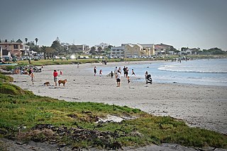
Melkbosstrand is a coastal town located on the South West Coast of South Africa, 30 km north of Cape Town. It forms part of the City of Cape Town Metropolitan Municipality, the municipality governing Cape Town and its greater metropolitan area.

Kingston Lisle is a village and civil parish in the Vale of White Horse, England, about 4+1⁄2 miles (7 km) west of Wantage and 5 miles (8 km) south-southeast of Faringdon. The parish includes the hamlet of Fawler, about 1⁄2 mile (800 m) west of Kingston Lisle village. The 2011 Census recorded the parish population as 225. Kingston Lisle was part of Berkshire until the 1974 local government boundary changes transferred the Vale of White Horse to Oxfordshire.

Peckforton is a scattered settlement and civil parish in the unitary authority of Cheshire East and the ceremonial county of Cheshire, England. The settlement is located 6.5 miles (10.5 km) to the north east of Malpas and 7.5 miles (12.1 km) to the west of Nantwich. The civil parish covers 1,754 acres (710 ha), with an estimated total population of 150 in 2006. The area is predominantly agricultural. Nearby villages include Bulkeley to the south, Beeston to the north, Higher Burwardsley to the west, Spurstow to the east and Bunbury to the north east.

Baptist Chapel, Great Warford is located in Merryman's Lane in the village of Great Warford, Cheshire, England. It is recorded in the National Heritage List for England as a designated Grade II* listed building.
Llanon is a village in Ceredigion, Wales. It adjoins the village of Llansantffraed on the coast of Cardigan Bay, 5 mi (8.0 km) north of Aberaeron and 11 miles (18 km) south of Aberystwyth on the A487 road. It is situated on a raised beach. The village is named after the church of Saint Non (llan-Non), the mother of Saint David. By tradition, St David was born and brought up in Llanon.
Howiesons Poort is a lithic technology cultural period in the Middle Stone Age in Africa named after the Howieson's Poort Shelter archeological site near Grahamstown in South Africa. It seems to have lasted around 5,000 years between roughly 65,800 BP and 59,500 BP.

Llanrhian is a small village, community and parish in Pembrokeshire in west Wales, near the coast, south of Porthgain village.

Rait is a small village in Perth and Kinross, Scotland. It lies 2+1⁄2 miles northwest of Errol, in the Gowrie area west of Dundee, on a minor road crossing the Sidlaw Hills through the Glen of Rait. The village is mainly residential with stone cottages, some modern developments and also features some single storey thatched cottages dating back to the 1700s or early 1800s which form a fermtoun. The former parish church, now ruined, was built in the Middle Ages, and abandoned in the 17th century when the parish of Rait was merged with Kilspindie. The remains of a prehistoric promontory fort lie to the east of the village. The 16th-century Fingask Castle is located to the north of the village, on the south-facing slopes of the Sidlaw Hills.

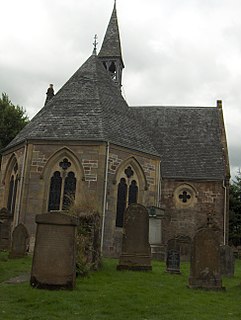
Hilderstone is a village and a civil parish in the English county of Staffordshire.
Lyn Wadley is an honorary professor of archaeology, and also affiliated jointly with the Archaeology Department and the Institute for Evolution at the University of the Witwatersrand in Johannesburg, South Africa.

Gnisvärd, is a fishing village in Tofta on the central west coast of the island of Gotland, Sweden. Gnisvärd is mostly known for its stone ships and harbor.
Rose Cottage Cave (RCC) is an archaeological site in the Free State, South Africa, situated only a few kilometers away from Ladybrand close to the Caledon River on the northern slopes of the Platberg. RCC is an important site because of its long cultural sequence, its roots of modern human behavior, and the movement of early modern humans out of Africa. Rose Cottage is the only site from the Middle Stone Age that can tell us about the behavioral variability of hunter-gatherers during the Late Pleistocene and Holocene. Berry D. Malan excavated the site between 1943 and 1946, shortly succeeded by Peter B. Beaumont in the early 1960s, and the most recent excavations occurred from 1987 to 1997 by Lyn Wadley, and Philip Harper in 1989 under Wadley's supervision. Humans have inhabited of Rose Cottage for over 100,000 years throughout the Middle and Later Stone Ages. Site formation and sediment formation processes at Rose Cottage appear to be primarily anthropogenic. Archaeological research focuses primarily on blade technology and tool forms from the Middle Stone Age and the implications of modern human behavior. Structurally, the cave measures more than 6 metres (20 ft) deep and about 20 by 10 metres. A boulder encloses the front, protecting the cave, but allowing a small opening for a skylight and narrow entrances on both the east and west sides.


