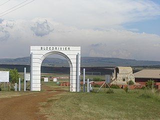
The Battle of Blood River was fought on the bank of the Ncome River, in what is today KwaZulu-Natal, South Africa between 464 Voortrekkers ("Pioneers"), led by Andries Pretorius, and an estimated 10,000 to 15,000 Zulu. Estimations of casualties amounted to over 3,000 of King Dingane's soldiers dead, including two Zulu princes competing with Prince Mpande for the Zulu throne. Three Voortrekker commando members were lightly wounded, including Pretorius.
The year 1838 was the most difficult period for the Voortrekkers from when they left the Cape Colony, till the end of the Great Trek. They faced many difficulties and much bloodshed before they found freedom and a safe homeland in their Republic of Natalia. This was only achieved after defeating the Zulu Kingdom, at the Battle of Blood River, which took place on Sunday 16 December 1838. This battle would not have taken place if the Zulu King had honored the agreement that he had made with the Voortrekkers to live together peacefully. The Zulu king knew that they outnumbered the Voortrekkers and decided to overthrow them and that led to the Battle of Blood river.

The Voortrekker Monument is located just south of Pretoria in South Africa. The granite structure is located on a hilltop, and was raised to commemorate the Voortrekkers who left the Cape Colony between 1835 and 1854. It was designed by the architect Gerard Moerdijk.
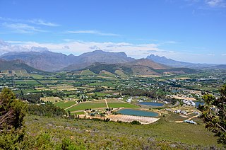
Franschhoek is a small town in the Western Cape Province and one of the oldest towns in South Africa. Formerly known as Oliphants hoek. It is situated about 75 kilometres from Cape Town a 45 minute drive away. The whole area including townships such as Groendal and suburbs such as Wemmershoek has a population of slightly over 20,000 people while the town proper, known as Hugenote, has a population of around 1,000. Since 2000, it has been incorporated into Stellenbosch Municipality. Mentioned in Time (magazine) top 50 places in the world to visit for 2022.
Cape Agulhas Municipality is a municipality located in the Western Cape Province of South Africa. As of 2011 it had a population of 33,038. Its municipality code is WC033. It is named after Cape Agulhas, the southernmost point of Africa. The largest town is Bredasdorp, which is the seat of the municipal headquarters. It also includes the villages of Napier, Struisbaai, Elim, Arniston and L'Agulhas, and the De Hoop Nature Reserve.

Arniston is a small seaside settlement on the coast of the Overberg region of South Africa, close to Cape Agulhas, the southernmost tip of Africa. Prior to the wreck of Arniston, it is also known as Waenhuiskrans, an Afrikaans name meaning literally "Wagon house cliff", after a local sea cave large enough to accommodate a wagon and a span of oxen.

L'Agulhas is the most southern coastal village and holiday resort in South Africa, located within the Cape Agulhas Local Municipality at the southernmost tip of the African mainland. It is situated next to the town of Struisbaai and about 30 kilometres (20 mi) south of the regional centre of Bredasdorp. The name "Agulhas", Portuguese for "needles", is said to have been given to the cape because the compass-needle was seen to point due north, that is, with no magnetic deviation. The Agulhas Bank is reputed to be the richest fishing area in the Southern Hemisphere. Some of the older residents and documents refer to the town as by its former name Cape Agulhas or Cape L'Agulhas or simply Agulhas which were the names that referred to this town before it was changed to L'Agulhas to avoid confusion when the Bredasdorp Municipality changed its name to The Cape Agulhas Municipality (CAM).

Pieter Kenyon Fleming-Voltelyn van der Byl was a Rhodesian politician who served as his country's Foreign Minister from 1974 to 1979 as a member of the Rhodesian Front (RF). A close associate of Prime Minister Ian Smith, Van der Byl opposed attempts to compromise with the British government and domestic black nationalist opposition on the issue of majority rule throughout most of his time in government. However, in the late 1970s he supported the moves which led to majority rule and internationally recognised independence for Zimbabwe.

Caledon is a town in the Overberg region in the Western Cape province of South Africa, located about 100 kilometres (62 mi) east of Cape Town next to mineral-rich hot springs. As of 2011 it had a population of 13,020. It is located in, and the seat of, the Theewaterskloof Local Municipality.

The Mayor of Cape Town is the head of the local government of Cape Town, South Africa; currently that government takes the form of the City of Cape Town Metropolitan Municipality. In the past, the position of Mayor has varied between that of an executive mayor actively governing the city and that of a figurehead mayor with a mostly ceremonial role. The current mayor is Geordin Hill-Lewis of the Democratic Alliance (DA)

Bredasdorp is a town in the Southern Overberg region of the Western Cape, South Africa, and the main economic and service hub of that region. It lies on the northern edge of the Agulhas Plain, about 160 kilometres (100 mi) south-east of Cape Town and 35 kilometres (22 mi) north of Cape Agulhas, the southernmost tip of Africa.
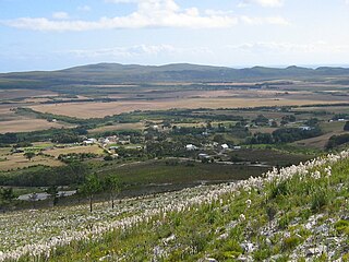
Baardskeerdersbos is a village in the Overberg region of the Western Cape province of South Africa. According to the 2011 census it has a population of 103 residents.
Major Pieter Voltelyn Graham van der Byl MC was a South African soldier and statesman. In South African politics, he was a member of the liberal South African Party and then the United Party from 1929 to 1966 and a member of Jan Smuts' cabinet from 1939 to 1948, during which time, he was minister of Native Affairs. Major Piet was a chevalier de la Légion d'Honneur, Honorary Colonel of the University of Cape Town Regiment, as well as receiving the Military Cross and the King George VI Coronation Medal.

Louis Johannes Tregardt, commonly spelled Trichardt was a farmer from the Cape Colony's eastern frontier, who became an early voortrekker leader. Shunning colonial authority, he emigrated in 1834 to live among the Xhosa across the native reserve frontier, before he crossed the Orange River into northern territory. His northward trek, along with fellow trekker Johannes (Hans) van Rensburg, was commenced in early 1836. He led his small party of emigrants, composed of seven Boer farmers, with their wives and thirty-four children & native servants, into the uncharted interior of South Africa, and settled for a year at the base of the Zoutpansberg.
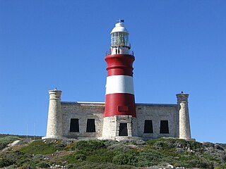
The Cape Agulhas Lighthouse is situated at Cape Agulhas, the southernmost tip of Africa. It was the third lighthouse to be built in South Africa, and the second-oldest still operating, after Green Point. It is located on the southern edge of the village of L'Agulhas, in the Agulhas National Park; the light is operated by Transnet National Ports Authority. In 2016, the American Society of Civil Engineers (ASCE) identified the lighthouse as a deserving prominent historic engineering project and International Historic Civil Engineering Landmark.
Coetsenburg is an historic wine estate and one of the oldest estates in South Africa, established in 1682. It is located at the foot of the Stellenbosch Mountain, which forms part of the estate, in the town of Stellenbosch, 31 miles (50 km) east of Cape Town, in the Cape Winelands of the Western Cape Province. The estate has historically been owned by the Coetsee family and is currently not open to the public. The north-western portion of the original estate is now the Coetsenburg Sports Grounds which belongs to the University of Stellenbosch.

Michiel van Breda (1775–1847) was a South African farmer, founder of Bredasdorp, Mayor of Cape Town and a Freemason.

The 1967 South African presidential election pitted Theophilus Ebenhaezer Dönges against Major Pieter Voltelyn Graham van der Byl. In accordance with the South African Constitution of 1961, the South African Parliament had the task of electing a person as State President, the ceremonial head of state.
Prince Alfred Roman of Liechtenstein was a Liechtensteiner prince and uncle of Franz Joseph II. He was the sixth child and fourth son of Prince Alfred of Liechtenstein and Princess Henriette of Liechtenstein.
Dirk Gysbertus van Reenen van Breda was a South African public official, farmer and twice Mayor of Cape Town.


