
Overberg is a region in South Africa to the east of Cape Town beyond the Hottentots-Holland mountains. It lies along the Western Cape Province's south coast between the Cape Peninsula and the region known as the Garden Route in the east. The boundaries of the Overberg are the Hottentots-Holland mountains in the West; the Riviersonderend Mountains, part of the Cape Fold Belt, in the North; the Atlantic and Indian Oceans in the South and the Breede River in the East.

Overstrand Municipality is a local municipality in the Western Cape province of South Africa. It is located along the Atlantic coast between Cape Town and Cape Agulhas, within the Overberg District Municipality. The principal towns in the municipality are Hermanus, Gansbaai and Kleinmond. As of 2011, it had a population of 80,432.

Cape Agulhas Municipality is a municipality located in the Western Cape province of South Africa. As of 2011, it had a population of 33,038. Its municipality code is WC033. It is named after Cape Agulhas, the southernmost point of Africa. The largest town is Bredasdorp, which is the seat of the municipal headquarters. It also includes the villages of Napier, Struisbaai, Elim, Arniston and L'Agulhas, and the De Hoop Nature Reserve.

Swellendam Municipality is a local municipality located within the Overberg District Municipality, in the Western Cape province of South Africa. As of 2011, it had a population of 35,916. Its municipality code is WC034.
Theewaterskloof Municipality is a local municipality located within the Overberg District Municipality, in the Western Cape province of South Africa. As of 2007, the population was 108,790. Its municipality code is WC031. The enormous Theewaterskloof Dam, which provides water for Cape Town and the surrounding areas, is located in this municipality.

The Overberg District Municipality is a district municipality that governs the Overberg region in the Western Cape province of South Africa. It is divided into four local municipalities and includes the major towns of Grabouw, Caledon, Hermanus, Bredasdorp and Swellendam. The municipal area covers 12,241 square kilometres (4,726 sq mi) and had in 2007 an estimated population of 212,787 people in 60,056 households.

Gansbaai is a fishing town and popular tourist destination in the Overberg District Municipality, Western Cape, South Africa. It is known for its dense population of great white sharks and as a whale-watching location.

Helderberg refers to a planning district of the City of Cape Town metropolitan municipality, the mountain after which it is named, a wine-producing area in the Western Cape province of South Africa, or a small census area in Somerset West.

Napier is a village at the foot of the Soetmuisberg, between Caledon and Bredasdorp. A blend of century-old cottages and modern houses, surrounded by the rolling farmland which typifies the Overberg region of South Africa, give the village a rural atmosphere.
Botrivier is a small town of approximately 10 000 people, situated in the Overberg region of the Western Cape in South Africa.

Elgin is a large, lush area of land, circled by mountains, in the Overberg region of South Africa. This broad upland valley lies about 70 km southeast of Cape Town, just beyond the Hottentots Holland Mountains.

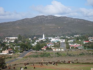
Caledon is a town in the Overberg region in the Western Cape province of South Africa, located about 100 kilometres (62 mi) east of Cape Town next to mineral-rich hot springs. As of 2011 it had a population of 13,020. It is located in, and the seat of, the Theewaterskloof Local Municipality.
Bredasdorp is a town in the Southern Overberg region of the Western Cape, South Africa, and the main economic and service hub of that region. It lies on the northern edge of the Agulhas Plain, about 160 kilometres (100 mi) south-east of Cape Town and 35 kilometres (22 mi) north of Cape Agulhas, the southernmost tip of Africa.
Salmonsdam Nature Reserve is a nature reserve in the Overberg region of the Western Cape province of South Africa. It contains the mountain catchment area of the Paardensberg River in the Akkedisberg mountains. The reserve is administered by CapeNature and covers an area of 834 hectares.
Franskraalstrand, also known as Franskraal, is a coastal village near to Gansbaai in the Western Cape province of South Africa. As of 2011 it had a population of 1,165 people in 592 households.
Stanford is a small riverside village in Overberg District Municipality in the Western Cape province of South Africa. Located 16 km east of Hermanus and 22 km north-east of Gansbaai.

The Overberg branch line is a railway line in the Western Cape, South Africa. It runs from Cape Town through Somerset West and Caledon to Bredasdorp.
Wolvengat, also known as Viljoenshof, is a village in the southern Overberg region, in the Western Cape province of South Africa. It is situated 10 kilometres (6 mi) south of Elim and 35 kilometres (22 mi) southwest of Bredasdorp. It was originally named Wolfgat or Wolvengat in reference to the brown hyena, known as strandwolf in Afrikaans. However, when the local post office was established the authorities named it Viljoenshof in honour of DJ Viljoen, the Dutch Reformed (NGK) minister of Bredasdorp from 1904 to 1934; this name was then extended to the village. The original name Wolvengat was officially restored in 1991.
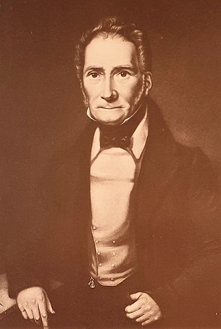
Michiel van Breda was a South African farmer, founder of Bredasdorp, Mayor of Cape Town and a Freemason.
Uilenkraalsmond or Uilenkraal is a populated place located in the village of Franskraalstrand, Overstrand Local Municipality of the Overberg District Municipality, in the Western Cape province of South Africa.


