
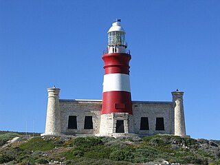
Cape Agulhas is a rocky headland in Western Cape, South Africa. It is the geographic southern tip of Africa and the beginning of the traditional dividing line between the Atlantic and Indian Oceans according to the International Hydrographic Organization. It is approximately half a degree of latitude, or 55 kilometres (34 mi), further south than the Cape of Good Hope.

Cape Point is a promontory at the southeast corner of the Cape Peninsula, a mountainous and scenic landform that runs north-south for about thirty kilometres at the extreme southwestern tip of the African continent in South Africa. Table Mountain and the city of Cape Town are close to the northern extremity of the same peninsula. The cape is located at 34°21′26″S18°29′51″E, about 2.3 kilometres (1.4 mi) east and a little north of the Cape of Good Hope on the southwest corner. Although these two rocky capes are very well known, neither cape is actually the southernmost point of the mainland of Africa; that is Cape Agulhas, approximately 150 kilometres (93 mi) to the east-southeast.

HMS Birkenhead, also referred to as HM Troopship Birkenhead or Steam Frigate Birkenhead, was one of the first iron-hulled ships built for the Royal Navy. She was designed as a steam frigate, but was converted to a troopship before being commissioned.

SS Thistlegorm was a British cargo steamship that was built in North East England in 1940 and sunk by German bomber aircraft in the Red Sea in 1941. Her wreck near Ras Muhammad is now a well-known diving site.

Struisbaai is a coastal town in the Overberg region of South Africa's Western Cape province. The town is in the Cape Agulhas Local Municipality in the Overberg District, about two hundred kilometres south east of Cape Town, and four kilometres from Cape Agulhas, which is the southernmost point of the African continent.

Paternoster is one of the oldest fishing villages on the West Coast of South Africa. It is situated 15 km north-west of Vredenburg and 145 km north of Cape Town, at Cape Columbine between Saldanha Bay and St Helena Bay. The town covers an area of 194.8 hectare and has approximately 1883 inhabitants.
The following lists events that happened during 1815 in South Africa.

Gansbaai is a fishing town and popular tourist destination in the Overberg District Municipality, Western Cape, South Africa. It is known for its dense population of great white sharks and as a whale-watching location.
East Indiaman was a general name for any sailing ship operating under charter or licence to any of the East India trading companies of the major European trading powers of the 17th through the 19th centuries. The term is used to refer to vessels belonging to the Austrian, Danish, Dutch, English, French, Portuguese, or Swedish companies.

L Agulhas is the most southern coastal village and holiday resort in South Africa, located within the Cape Agulhas Local Municipality at the southernmost tip of the African mainland. It is situated next to the town of Struisbaai and about 30 kilometres (20 mi) south of the regional centre of Bredasdorp. The name "Agulhas", Portuguese for "needles", is said to have been given to the cape because the compass-needle was seen to point due north, that is, with no magnetic deviation. The Agulhas Bank is reputed to be the richest fishing area in the Southern Hemisphere. Some of the older residents and documents refer to the town as by its former name Cape Agulhas or Cape L'Agulhas or simply Agulhas which were the names that referred to this town before it was changed to L'Agulhas to avoid confusion when the Bredasdorp Municipality changed its name to The Cape Agulhas Municipality (CAM).

The 73rd Regiment of Foot was an infantry regiment of the British Army, raised in 1780. Under the Childers Reforms it amalgamated with the 42nd Regiment of Foot to form the Black Watch in 1881.

Napier is a village at the foot of the Soetmuisberg, between Caledon and Bredasdorp. A blend of century-old cottages and modern houses, surrounded by the rolling farmland which typifies the Overberg region of South Africa, give the village a rural atmosphere.

Bredasdorp is a town in the Southern Overberg region of the Western Cape, South Africa, and the main economic and service hub of that region. It lies on the northern edge of the Agulhas Plain, about 160 kilometres (100 mi) south-east of Cape Town and 35 kilometres (22 mi) north of Cape Agulhas, the southernmost tip of Africa.
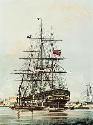
Arniston was an East Indiaman that made eight voyages for the British East India Company (EIC). She was wrecked on 30 May 1815 during a storm at Waenhuiskrans, near Cape Agulhas, South Africa, with the loss of 372 lives – only six on board survived. She had been chartered as a troopship and was underway from Ceylon to England on a journey to repatriate wounded soldiers from the Kandyan Wars.
Johanna was an East Indiaman for the British East India Company (EIC), possibly named for the island of Anjouan, then known as Johanna. She made five voyages for the EIC between c. 1671 and 1681, On her sixth voyage she became the first Indiaman lost on the South African coast when she wrecked on 8 June 1682.
The Agulhas National Park is a South African national park located in the Agulhas Plain in the southern Overberg region of the Western Cape, about 200 kilometres (120 mi) south-east of Cape Town. The park stretches along the coastal plain between the towns of Gansbaai and Struisbaai, and includes the southern tip of Africa at Cape Agulhas. As of January 2009 it covered an area of 20,959 hectares. Although one of the smallest national parks in South Africa, it boasts 2,000 native plant species and a wetland that provides refuge to birds and amphibians.
Charming Kitty was a ship captured from the Spanish. She first appeared in Gret Britain's Protection Lists for whalers in 1799. She conducted four whaling voyages between 1799 and 1808 before becoming a West Indiaman, trading with the Caribbean. She was wrecked in October 1813.
Union was launched at Calcutta in 1801. She sailed to England and then made five voyages as an East Indiaman for the British East India Company (EIC), between 1805 and 1814. She was wrecked in late 1815 or early 1816.
This is a list of seaside resorts in South Africa. These seaside resorts are in the Eastern Cape, KwaZulu-Natal, Northern Cape and Western Cape provinces which are all coastal provinces of South Africa.
Remembering Arniston: A Bicentenary Picture Book in Commemoration of the Wreck of the HMS Arniston, South Africa, 30 May 1815 Paperback


