Lands of Dallars

Last updated

Lands of Dallars
East Ayrshire UK location map.svg
Red pog.svg
Lands of Dallars
Location within East Ayrshire
OS grid reference NS403488
Council area
Lieutenancy area
Country Scotland
Sovereign state United Kingdom
Post town Kilmarnock
Police Scotland
Fire Scottish
Ambulance Scottish
List of places
UK
Scotland
55°34′22″N4°26′16″W / 55.5728°N 4.4379°W / 55.5728; -4.4379 Coordinates: 55°34′22″N4°26′16″W / 55.5728°N 4.4379°W / 55.5728; -4.4379

The Lands of Dallars or Auchenskeith (NS463337) form a small estate in East Ayrshire, Hurlford, Kilmarnock, Parish of Riccarton, Scotland. The present mansion house is mainly late 18th-century, located within a bend of the Cessnock Water on the site of older building/s. "Dullers or Dillers" was changed to "Auchenskeith" or "Auchinskeigh" (sic) as well as other variants and then the name reverted nearer to the original form as "Dollars" and then finally "Dallars". [1] Dallars lies 3.25 km south of Hurlford.

Contents

For consistency the spellings 'Cuningham'; Dallars; Auchenskeith are used unless otherwise denoted (sic).

History

The estate lies on the old northern boundary of Cunninghame in the district of Kyle, bordering the lands of the Campbells of Loudoun to the north and the Wallaces to the west with Haining Place and the Barony of Haining-Ross lying upstream of the Cessnock Water to the north-west. [2]

The Laird's House, Farm and the Estate

Neidpath, a typical Scottish tower castle. Neidpath Castle 2014 1.jpg
Neidpath, a typical Scottish tower castle.

Built on a low hill, the site gave a clear view of the surrounding area and originally would have been a fortified building such as a tower house. The later mansion house is a Category B Listed Building. [3] The date of the completion of the mansion house, 1779, is carved onto a gable skew of a garden shed at the walled garden. The mansion house is three storeys high; the porch may be a later addition. The flanking wings are a Victorian addition. [3] The estate buildings included stables, part of which date from around 1635; Mains Farm; a dovecot and a walled garden of brick enhanced by rusticated, finial ball topped, stone piers. [4]

The designed landscape of the estate policies has evolved during the 18th and 19th centuries, with an original plan of tree-lined parks developing into a less formal landscape. [5]

The estate's name was changed to 'Auchenskeith' following its purchase by the owner of the Auchenskeith estate near Dalry in North Ayrshire.

The 1855-57 OS Name Book gives most of the 1764 sasine properties now being held by a Colonel Cathcart and Dallars Mains farm is as well with a William Cunningham as occupier. [6]

The Lairds

An Archibald Dunlop who married a Craufurd of Craufurdland is thought to be the first named holder of "Dullers" (sic).

William Cunningham had sasine of the lands of Auchinskeith (sic) in 1712 and died in 1727. [7] A Dead bell was used to announce a death and rung with the funeral cortege, the Kilmarnock funeral bell carries the inscription "Kilmarnock, 1639". Its use was remembered by local inhabitants still alive in the 1850s and William's heir paid six pounds Scots for its use in 1727. [7]

Another William Cunningham of Auchenskeith inherited and became a burgess of Ayr in 1738. [7]

In 1764 a William Cunningham of Auchenskeith and his son, also William, had sasine of the 20s lands of Inchbean; 10s lands of Commonend; 40s lands of Whatriggs; 2 merk lands of Wester Mosside; 1 merk lands of Wester Mosside; 1 merk land of Easter Mosside; 2 1/2 merk lands of Hole of Commonhead and Clayslope; the 40d land of Commonhead, etc. [7] These lands in the Kilmarnock, Riccarton and Hurlford area had been held by Hugh, Earl of Marchmont. [7]

Captain William Cuningham held the lands in the late 1760s. On a visit to St Kitts in the West Indies he met and married Agnes Colquhoun, daughter of a plantation manager, Robert Colquhoun in 1770. [2] A John Begbie was a servant to Captain William Cuningham as shown by the Servants Tax Roll for 1777-78. [2]

Auchenskeith Farm, Dalry. Auchenskeith Farm - geograph.org.uk - 991427.jpg
Auchenskeith Farm, Dalry.

A William Cuningham of Auchenskeith in 1767 sold the lands of Langlands to Dr.Park. [8]

In 1775 Alexander Cuningham, second son of William, became an Ayr burgess.

In 1803 Quintin MacAdam of Berbeth, later known as Craigengillan, was the owner of Dallars, however in 1805 he committed suicide, a trustee of the estate was Sir William Cuningham and the property was rented out. [2]

In 1847 the daughter of Colonel William MacAdam, Honoria Mary, married Edward Carleton Tufnell (b.1806. d.1886) and the couple lived at Dallars. Edward was a supporter of teacher training colleges and he acted in London from 1835 to 1846 as a commissioner of the Poor Laws. [9]

In 1878 their son, Carleton Tufnell (b.1848, d.1893) as a retired Royal Navy Commander, married a daughter of the 1st Viscount Anson. [10]

In 1885 Lady Adelaide Hastings, sister of Sophia, Marchioness of Bute, was in residence at Dallars whilst the estate was owned by the Honourable Jean MacAdam Cathcart of Craigengillan. [11]

In 1962 the Richards family purchased Dallars. [9]

Auchenskeith, Dalry

Recorded as 'Achin-skyich' by Timothy Pont and derived from the Scots Gaelic "Achad-na-sgitheach" meaning in English the "Field of thorns." The lands were originally a part of the Blair estates but were held by the Dunlops of that Ilk for three centuries. [12] Auchenskeith passed to the Cuninghams of Robertland, however in 1818 Sir William Cuningham of Robertland and Auchenskeith (Dallars), sold the Cuninghame estate of Auchenskeith to Colonel William Blair of Blair. [13]

A view of Robertland Mansionhouse. Circa 1930. Robertlandhouse.jpg
A view of Robertland Mansionhouse. Circa 1930.

Burns is recorded to have visited occasionally and Lochlea Farm lies just two miles away. Auchenskeith is said by Burns to have been in his mind when he wrote the suppressed stanza "Where Cessnock pours in gurgling sound." from "The Vision." [1] Sir William Cuningham's tutor was the Rev. James McKinlay, Minister of Kilmarnock's Laigh Kirk, who figures in the poem "The Ordination". [1] In 1789 Burns asked Captain Robert Riddell of Friars Carse to forward a letter to Sir William Cuningham. [14] The Lady 'C', referred to in a letter of 3 April 1786 to Robert Aitken in Ayr, may have been to Lady Cuningham. [14]

Sir William Cuningham of Auchenskeith and Robertland, acquired the Robertland House near Stewarton through marriage to Margaret Fairlie of Fairlie and he is known to have invited Robert Burns to Robertland. [15] Robert Burnes, uncle to the poet and latterly a resident in Stewarton, was a Robertland estate Land Steward. [14]

Alison Begbie or Elizabeth Gebbie is said to have been proposed to by Robert Burns. She was the daughter of a farmer and at the time of her courtship and was a servant employed at the Carnell House, then known as Cairnhill, [16] also close to the Cessnock Water. Alison Begbie may have been brought up at 'Old Place', near Shawsmill Farm and just a short distance downstream of Haining Place. [17] Burns was living at Lochlea Farm at this time. [18] [19] John Gebbie was the tenant at Millhill Farm near Old Place and his brother Alexander was the miller at Cessnock Mill next to Millhill. A third brother, Thomas, farmed at Pearsland and had a daughter, Elizabeth, who was born on 22 July 1762 and is suggested to have been Robert Burns's love interest. [20]

Alison met Burns in 1781 near Lochlea Farm and it is of interest that a John Begbie was a servant to Captain William Cuningham as shown by the Servants Tax Roll for 1777-78. [2]

Lady Sophia Rawdon-Hastings

In 1845 Lady Sophia Rawdon-Hastings the daughter of the Marquess of Hastings had married Second Marquess of Bute, however he died and left his widow with a six month old son, who would become the Third Marquess, John Patrick Crichton Stuart.

The 2nd Marquess's brother, Lord James denied Lady Sophia and her son use of either Dumfries House at Cumnock or Mount Stuart on the Isle of Bute. Lady Sophia rented Dallars House that was close to Loudoun Castle. They stayed at Dallars between 1849 and 1853 after which they moved to Mount Stuart. [2] [21] She also rented Largo House near St Andrews for the summer months. In 1855-57 the Marchioness of Bute was still recorded as renting Dallars, with her sister Lady Adelaide Hastings in residence. [22] [11]

Natural history

The Haining Place Castle mound and the Gypsy Path. Haining Place, castle mound and Gypsy Path.JPG
The Haining Place Castle mound and the Gypsy Path.

The site has a large Spanish Chestnut (Castanea sativa) that is said to have been planted by William and Agnes Cuningham. [2] The walled garden has the very rare Mistletoe (Viscum album) growing on an apple tree.

Cartographic evidence

In the 1662 map by Joan Blaeu based on the earlier map by Timothy Pont the name is given as 'Dullers' with a pale or fence built part way around the dwelling which was also wooded. [23] In 1732 the site is also shown as "Dullers". [24]

The 1747 William Roy map records the name "Dillars," with Dillars Shaw and Shaws Mill. Cesnock and Cesnock Yards lay on the opposite bank of the Cesnnock Water. [25]

An Auchenskeigh (sic) is shown on Andrew Armstrong's map of 1775 for the first time. [26] The name "Auchenskaith" (sic) is shown in 1821 on Ainslie's map. [27]

In 1776 Taylor and Skinner's map of 1776 shows the estate of 'Auchenskeich' (sic) as the property of Captain Cuningham, with a mansion house shown prior to the 1779 construction date of the central section of the present building. [28]

In 1828 the name "Dallars" replaces the variations of Auchenskeith. [29]

The 1855-57 Ordnance Survey Book gives the name in the form Dollars as confirmed by the factor, Kennedy Smith and William Woodburn of Shaws Mill. [30]

Etymology

A story is told of how the name 'Auchenskeith' was changed to 'Dollars' to reflect the dowry that Captain William Cuningham obtained from Robert Colquhoun upon marrying his daughter Agnes. Robert was a plantation owner in the West Indies where the currency was the 'Dollar' and this money was used to build the original house. [2]

The name Dullers was recorded in the 1660s, well before the marriage of Sir William Cuningham to Agnes Colquhoun in 1770. Dallars may derive its name from the Welsh dol for 'meadow' and ar for ploughed land as in 'Dollar' near Alloa. As stated its name was changed to 'Auchenskeith' following its purchase by the owner of the Auchenskeith estate near Dalry in North Ayrshire. [31]

In 1855-57 the official name was recorded as "Dollars" in the OS Name Book. [22]

Properties in the locale

In 1855-57 Shaw's Mill (corn) was held by the Duke of Portland and the miller was William Woodburn. [32]

'Old Place' to the east was originally the seat of the Campbells of Cessnock before they built Cessnock Castle. Old Place became part of the lands of Shawmill and the house was eventually abandoned. [33]

In 1857 "Dollars" (sic) is shown with "Old Place" replacing "Cesnock" and a walled garden, Mains Farm, etc. are shown. [34] Later OS maps do not show 'Old Place.'

Communications

The 1854-59 OS map shows that an Aird bridge once crossed the Cessnock Water and a dwelling, Aird Bridgend, stood on the western bank. A road ran down from the main road, crossed the bridge and led up to Aird Farm whilst another led up to the main road, joining it near Snodston Farm. [35]

Micro-history

John Galloway, Esq., of Barleith and Dollars (sic) Collieries built an institute in New Street Riccarton for the use of the working-men in the locality. The building still survives as a Community Centre run by East Ayrshire Council. [36]

See also

Related Research Articles

<span class="mw-page-title-main">Stewarton</span> The Bonnet Toun

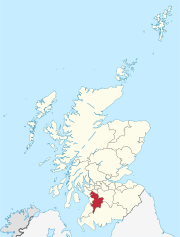
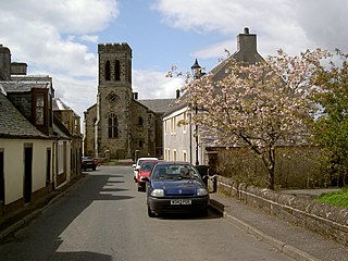
Stewarton is a town in East Ayrshire, Scotland. In comparison to the neighbouring towns of Kilmaurs, Fenwick, Dunlop and Lugton, it is a relatively large town, with a population estimated at over 7,400. It is 300 feet above sea level. The town is served by Stewarton railway station.

<span class="mw-page-title-main">Clan Cunningham</span> Scottish clan

Clan Cunningham is a Scottish clan. The traditional origins of the clan are placed in the 12th century. However, the first contemporary record of the clan chiefs is in the thirteenth century. The chiefs of the Clan Cunningham supported Robert the Bruce during the Wars of Scottish Independence. In the 15th and 16th centuries, the Clan Cunningham feuded with the Clan Montgomery. Historically, the chief of Clan Cunningham held the title of Earl of Glencairn. However, in modern times the chief of the clan is Cunningham of Corsehill. On 18 December 2013, Sir John Christopher Foggo Montgomery Cunninghame, Baronet of Corsehill, was recognized by Lord Lyon as Clan Chief after the chiefship had been vacant for over 200 years.

<span class="mw-page-title-main">Barony and Castle of Corsehill</span> Barony in East Ayrshire, Scotland

The old Barony and castle of Corsehill lay within the feudal Baillerie of Cunninghame, near Stewarton, now East Ayrshire, Scotland.

<span class="mw-page-title-main">Dunlop, East Ayrshire</span> Human settlement in Scotland

Dunlop is a village and parish in East Ayrshire, Scotland. It lies on the A735, north-east of Stewarton, seven miles from Kilmarnock. The road runs on to Lugton and the B706 enters the village from Beith and Burnhouse.

The village or hamlet of Gatehead is located in East Ayrshire, Parish of Kilmaurs, Scotland. It is one and a quarter miles from Crosshouse and one and a half miles from Kilmarnock. In the 18th and 19th centuries the locality was a busy coal mining district. The settlement runs down to the River Irvine where a ford and later a bridge was located.

Fergushill is a small community in North Ayrshire, Parish of Kilwinning, Scotland. The Barony of Fergushill was held by the Fergushill family of that Ilk and the area has a complex history.

<span class="mw-page-title-main">Busbie Castle</span>

Busbie Castle was situated in what is now known as Knockentiber, a village in East Ayrshire, Parish of Kilmaurs, Scotland. Knockentiber is 2 miles (3.2 km) WNW of Kilmarnock and 1/2 mile NE of Crosshouse. The castle overlooked the Carmel Glen and its Burn, which runs into the River Irvine, a mile or so to the south, after passing through the old Busbie Mill.

<span class="mw-page-title-main">Giffordland</span> Barony in North Ayrshire, United Kingdom

Giffordland is in North Ayrshire, Parish of Dalry (Cunninghame) in the former Region of Strathclyde, Scotland.

<span class="mw-page-title-main">Castle and Barony of Robertland</span>

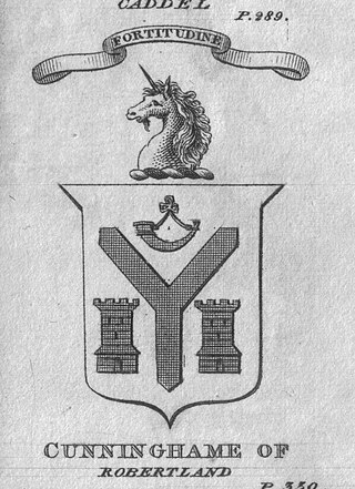
The Castle and Barony of Robertland is located near Stewarton, off the B769 road, in the old district of Cunninghame, Parish of Stewarton, and now part of East Ayrshire, Scotland.

<span class="mw-page-title-main">Lands of Lainshaw</span> The Lands Of Lainshaw Have Been In Place For Many Years And Was Used In The War.

The Lands of Lainshaw lie in Strathannick and were part of the Lordship of Stewarton, in East Ayrshire, Scotland. Lainshaw House is a category B listed mansion, lying in a prominent position above the Annick Water and its holm in the Parish of Stewarton, Scotland. Part of the much older Lainshaw Castle is contained within the several later building phases of the present day Lainshaw House. The names 'Langshaw' or 'Langschaw' were used in historic times. Law Mount near the High and Laigh Castleton farms has been suggested as the site of the original castle, granted in the 12th century to Godfrey de Ross by Hugo de Morville.

<span class="mw-page-title-main">Fail Loch</span> Body of water

Fail Loch or Faile Loch was situated in a low-lying area near the old monastery of Fail in the Parish of Tarbolton, South Ayrshire, Scotland. The old Lochlea Loch lies nearby and its waters still feed into Fail Loch via the Mill Burn.

<span class="mw-page-title-main">Polkelly Castle</span>

Polkelly Castle, also Pokelly, was an ancient castle located near Fenwick, at NS 4568 4524, in the medieval free Barony of Polkelly, lying north of Kilmarnock, Parish of Fenwick, East Ayrshire, Scotland. The castle is recorded as Powkelly (c1747), Pockelly (c1775), Pow-Kaillie, Ponekell, Polnekel, Pollockelly, Pollockellie, Pokellie, Pothelly, Pathelly Ha' and Polkelly. The name is given circa 1564 as Powkellie when it was held by the Cunninghams of Cunninghamhead.

The Lands of Cocklebie or Cocklebee formed an estate possessing a common border with the estates of Lainshaw, the Corsehill, and the town of Stewarton, East Ayrshire, Parish of Stewarton, Scotland.

<span class="mw-page-title-main">Barony of Kersland</span>

The remains of the old castle of Kersland lie about 1.5 miles to the north-east of the town of Dalry in North Ayrshire, Scotland, in the old Barony of Kersland. The River Garnock lies nearby.

<span class="mw-page-title-main">Kingsford, East Ayrshire</span> Human settlement in Scotland

Kingsford is a hamlet or clachan in Strathannick, East Ayrshire, parish of Stewarton, Scotland. The habitation is situated on the B769, two miles north of Stewarton and fourteen miles from Glasgow.

Swindridgemuir House and estate were composed of the 'Lands of Swindridgemuir' and the dwelling house about two miles north-east of Dalry in the old Barony of Kersland, about a mile and a half north of the Blair Estate, North Ayrshire, Scotland. The spelling on the family memorials at Ayr Auld Kirk is 'Swindrigemuir'.

<span class="mw-page-title-main">Murder of Hugh Montgomerie</span>

The Murder of Hugh Montgomerie, 4th Earl of Eglinton at the Annick Ford in Stewarton, East Ayrshire, Scotland, took place in 1586 as a consequence of a long running feud between the Montgomeries, Earls of Eglinton and the Cunninghames, Earls of Glencairn, families who were competing for power and influence locally and nationally. The significant repercussions of this act were felt throughout the county of Ayrshire and beyond. The spelling 'Montgomerie' is used throughout for both the family and Montgomery for the clan and clan and district names 'Cunninghame' in the same fashion.

<span class="mw-page-title-main">Lands of Tour and Kirkland</span> Human settlement in Scotland

The Lands of Tour and Kirkland (NS416406) formed a small estate close to the old Kirktoun and St Maurs-Glencairn collegiate church about 1 km south-east of Kilmaurs, East Ayrshire, Parish of Kilmaurs, Scotland. The word 'Tour' in Scots refers to a 'tower' and 'kirk' to a parish church.

<span class="mw-page-title-main">Haining Place and the Barony of Haining-Ross</span>

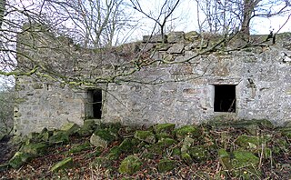
Haining Place or The Haining in the Parish of Kilmarnock lies near an old fording place across the Cessnock Water in East Ayrshire, Parish of Riccarton, Scotland. Hanyng (sic) was the caput or laird's dwelling of the Barony of Haining-Ross with a tower house or keep located in a defensive position on a high promontory of land, half encircled by the river. Later Haining Place may have been a dower house, then a tenanted farm, finally being used as farm workers accommodation. Haining Place is now a ruin following a fire. The old farm of Haining Mains is still located nearby.

<span class="mw-page-title-main">Lands of Blacklaw</span> Human settlement in Scotland

The Lands of Blacklaw formed a small property of five merks worth, in the Lordship of Stewarton at the eastern extremity of Strathannick, between the hamlet of Kingsford in East Ayrshire and the East Renfrewshire boundary, Scotland. It was first recorded in 1484 in the Acta Auditorum. Black Law is a prominent whinstone crag lying above Blacklaw Hill Farm.

References

Notes
  1. 1 2 3 Boyle, Andrew (1996). The Ayrshire Book of Burns-Lore. Alloway Publishing Ltd. p. 10. ISBN   0-907526-71-3.
  2. 1 2 3 4 5 6 7 8 Ayrshire Mansion - Dallars
  3. 1 2 British Listed Buildings
  4. Close, Rob (2012). Ayrshire and Arran - Buildings of Scotland. Yale University Press. p. 270. ISBN   978-0-300-14170-2.
  5. Parks and Gardens
  6. Scotland's Places
  7. 1 2 3 4 5 Paterson, James (1863). History of the Counties of Ayr and Wigton. V.2., Part 2. James Stillie. p. 645.
  8. Paterson, James (1863). History of the Counties of Ayr and Wigton. V.2., Part 2. James Stillie. p. 646.
  9. 1 2 Young, Alex (2017). The Country Houses, Castles and Mansions of East Ayrshire. Stenlake. p. 39. ISBN   9781840336306.
  10. County Families of Scotland
  11. 1 2 Young, Alex (2017). The Country Houses, Castles and Mansions of East Ayrshire. Stenlake. p. 38. ISBN   9781840336306.
  12. Dobie, p.49
  13. Dobie, p.50
  14. 1 2 3 Boyle, Andrew (1996). The Ayrshire Book of Burns-Lore. Alloway Publishing Ltd. p. 11. ISBN   0-907526-71-3.
  15. Hogg, Page 105
  16. Hunter, Page 169
  17. Mackay, Page 84
  18. Robert Burns Encyclopedia Retrieved : 9 February 2020
  19. Muir, John (1896). Burns at Galston and Ecclefechan. John Muir. p. 7.
  20. Mackay, James (1992). Burns. A Biography of Robert Burns. Alloway Publishing. p. 87. ISBN   0-907526-85-3.
  21. Hannah, p.7
  22. 1 2 Scotlands Places - Dollars
  23. Blaeu Atlas Maior, 1662-5 Volume 6 Blaeu Atlas Maior 1662-5, Volume 6. Coila Provincia
  24. The South Part of the Shire of Air [i.e. Ayr], containing Kyle and Carrick / by H. Moll.
  25. 1747-55 - William ROY - Military Survey of Scotland
  26. Armstrong, Andrew, 1700-1794. A new map of Ayrshire of 1775.
  27. Ainslie's Map of the Southern Part of Scotland. 1821.
  28. G Taylor and A Skinner's map
  29. Thomson, John, Northern Part of Ayrshire. Southern Part. 1828.
  30. Ordnance Survey Name Books Ayrshire OS Name Books, 1855-1857 Ayrshire volume 53 OS1/3/53/53
  31. Johnston, Page 102
  32. Scotland's Places
  33. Mackay, p.84
  34. Ayrshire XXIII.7 Survey date: 1857. Publication date:1893
  35. 1854-1859 - ORDNANCE SURVEY - 25 inch 1st edition maps of Scotland
  36. McKay, Archibald (1880) The History of Kilmarnock. Pub. Archibald McKay, Kilmarnock. P. 346.
Sources and Bibliography
  1. Archaeological & Historical Collections relating to Ayr & Wigton. 1884. Vol. IV. Shedden-Dobie, John. The Church of Dunlop.
  2. Bayne, John F. (1935). Dunlop Parish - A History of Church, Parish, and Nobility. Edinburgh : T. & A. Constable.
  3. Dobie, James D. (ed Dobie, J.S.) (1876). Cunninghame, Topographized by Timothy Pont 1604–1608, with continuations and illustrative notices. Glasgow: John Tweed.
  4. Fullarton, John (1864). Historical Memoir of the family of Eglinton and Winton. Ardrossan : Arthur Guthrie.
  5. Hannah, Rosemary The Grand Designer.
  6. Hogg, Patrick Scott (2008). Robert Burns. The Patriot Bard. Edinburgh : Mainstream Publishing. ISBN   9781845964122
  7. Johnston, J. B. (1903). Place-names of Scotland. Edinburgh : David Douglas.
  8. Mackenzie, W. Mackay (1927). The Medieval Castle in Scotland. Pub. Methuen & Co. Ltd.
  9. Mackay, James. A Biography of Robert Burns. Edinburgh : Mainstream Publishing. ISBN   1-85158-462-5.
  10. MacIntosh, John (1894). Ayrshire Nights Entertainments: A Descriptive Guide to the History, Traditions, Antiquities, etc. of the County of Ayr. Pub. Kilmarnock.
  11. McMichael, George (c. 1881 - 1890). Notes on the Way Through Ayrshire and the Land of Burn, Wallace, Henry the Minstrel, and Covenant Martyrs. Hugh Henry : Ayr.
  12. Ness, John (1990). Kilwinning Encyclopedia. Kilwinning & District Preservation Society.
  13. Paterson, James (1863–66). History of the Counties of Ayr and Wigton. V. - II - Cunninghame. Part II. Edinburgh : J. Stillie.