
The Greater London Authority (GLA), colloquially known by the metonym City Hall, is the devolved regional governance body of Greater London, England. It consists of two political branches: the executive Mayoralty and the 25-member London Assembly, which serves as a means of checks and balances on the former. Since May 2016, both branches have been under the control of the London Labour Party. The authority was established in 2000, following a local referendum, and derives most of its powers from the Greater London Authority Act 1999 and the Greater London Authority Act 2007.
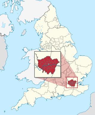
The London boroughs are the 32 local authority districts that together with the City of London make up the administrative area of Greater London, England; each is governed by a London borough council. The present London boroughs were all created at the same time as Greater London on 1 April 1965 by the London Government Act 1963 and are a type of local government district. Twelve were designated as Inner London boroughs and twenty as Outer London boroughs. The City of London, the historic centre, is a separate ceremonial county and sui generis local government district that functions quite differently from a London borough. However, the two counties together comprise the administrative area of Greater London as well as the London Region, all of which is also governed by the Greater London Authority, under the Mayor of London.

The Greater London Council (GLC) was the top-tier local government administrative body for Greater London from 1965 to 1986. It replaced the earlier London County Council (LCC) which had covered a much smaller area. The GLC was dissolved in 1986 by the Local Government Act 1985 and its powers were devolved to the London boroughs and other entities. A new administrative body, known as the Greater London Authority (GLA), was established in 2000.
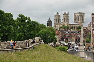
City status in the United Kingdom is granted by the monarch of the United Kingdom to specific centres of population, which might or might not meet the generally accepted definition of cities. As of 22 November 2022, there are 76 cities in the United Kingdom—55 in England, seven in Wales, eight in Scotland, and six in Northern Ireland. Although it carries no special rights, the status of city can be a marker of prestige and confer local pride.
The Royal Borough of Greenwich is a London borough in southeast Greater London, England. The London Borough of Greenwich was formed in 1965 by the London Government Act 1963. The new borough covered the former area of the Metropolitan Borough of Greenwich and part of the Metropolitan Borough of Woolwich to the east. The local council is Greenwich London Borough Council which meets in Woolwich Town Hall. The council's offices are also based in Woolwich, the main urban centre in the borough.

Middlesex was a county in southeast England. Its area was almost entirely within the wider urbanised area of London and mostly within the ceremonial county of Greater London, with small sections in neighbouring ceremonial counties. The county's boundaries largely followed three rivers: the Thames in the south, the Lea to the east and the Colne to the west. A line of hills formed the northern boundary with Hertfordshire.

The London County Council (LCC) was the principal local government body for the County of London throughout its existence from 1889 to 1965, and the first London-wide general municipal authority to be directly elected. It covered the area today known as Inner London and was replaced by the Greater London Council. The LCC was the largest, most significant and most ambitious English municipal authority of its day.

The County of London was a county of England from 1889 to 1965, corresponding to the area known today as Inner London. It was created as part of the general introduction of elected county government in England, by way of the Local Government Act 1888. The Act created an administrative County of London, which included within its territory the City of London. However, the City of London and the County of London formed separate ceremonial counties for "non-administrative" purposes. The local authority for the county was the London County Council (LCC), which initially performed only a limited range of functions, but gained further powers during its 76-year existence. The LCC provided very few services within the City of London, where the ancient Corporation monopolised local governance. In 1900, the lower-tier civil parishes and district boards were replaced with 28 new metropolitan boroughs. The territory of the county was 74,903 acres (303.12 km2) in 1961. During its existence, there was a long-term decline in population as more residents moved into the outer suburbs; there were periodic reviews of the local government structures in the greater London area and several failed attempts to expand the boundaries of the county. In 1965, the London Government Act 1963 replaced the county with the much larger Greater London administrative area.

Inner London is the name for the group of London boroughs that form the interior part of Greater London and are surrounded by Outer London. With its origins in the bills of mortality, it became fixed as an area for statistics in 1847 and was used as an area of local government from 1855 to 1965 principally as the County of London or earlier as the Metropolitan Board of Works Area (metropolis). It now has two common definitions. The first is the statutory definition delineated in the London Government Act 1963, coming into force on 1 April 1965, comprising twelve Inner London boroughs and almost identical to the County of London that was abolished at the same time. The second is the definition used by the Office for National Statistics comprising eleven of the statutory Inner London boroughs and two of the statutory Outer London boroughs, as well as the City of London.
The new towns in the United Kingdom were planned under the powers of the New Towns Act 1946 and later acts to relocate populations in poor or bombed-out housing following the Second World War. They were developed in three waves. Later developments included the expanded towns: existing towns which were substantially expanded to accommodate what was called the "overspill" population from densely populated areas of deprivation.
Local government is the third-level of government in Australia, administered with limited autonomy under the states and territories, and in turn beneath the federal government. Local government is not mentioned in the Constitution of Australia, and two referendums in 1974 and 1988 to alter the Constitution relating to local government were unsuccessful. Every state/territory government recognises local government in its own respective constitution. Unlike the two-tier local government system in Canada or the United States, there is only one tier of local government in each Australian state/territory, with no distinction between counties and cities.
Local education authorities (LEAs) were defined in England and Wales as the local councils responsible for education within their jurisdictions. The term was introduced by the Education Act 1902 which transferred education powers from school boards to existing local councils.

East London is the northeastern part of London, England, east of the ancient City of London and north of the River Thames as it begins to widen. East London developed as London's docklands and the primary industrial centre. The expansion of railways in the 19th century encouraged the eastward expansion of the East End of London and a proliferation of new suburbs. The industrial lands of East London are today an area of regeneration, which are well advanced in places such as Canary Wharf and ongoing elsewhere.

The Metropolitan Police District (MPD) is the police area which is policed by the Metropolitan Police Service in London. It currently consists of the ceremonial county of Greater London, which excludes the City of London. The Metropolitan Police District was created by the Metropolitan Police Act 1829 as an ad hoc area of administration because the built-up area of London spread at the time into many parishes and counties without an established boundary. The district expanded as the built up area grew and stretched some distance into rural land. When county police forces were set up in England, those of Essex, Hertfordshire, Kent and Surrey did not cover the parts of the counties within the MPD, while Middlesex did not have a county force. Similarly, boroughs in the MPD that elsewhere would have been entitled to their own police force did not have them.
The London Government Act 1963 is an act of the Parliament of the United Kingdom, which created Greater London and a new local government structure within it. The Act significantly reduced the number of local government districts in the area, resulting in local authorities responsible for larger areas and populations. The upper tier of local government was reformed to cover the whole of the Greater London area and with a more strategic role; and the split of functions between upper and lower tiers was recast. The Act classified the boroughs into inner and outer London groups. The City of London and its corporation were essentially unreformed by the legislation. Subsequent amendments to the Act have significantly amended the upper tier arrangements, with the Greater London Council abolished in 1986, and the Greater London Authority introduced in 2000. As of 2016, the London boroughs are more or less identical to those created in 1965, although with some enhanced powers over services such as waste management and education.

Salford was, from 1844 to 1974, a local government district in the county of Lancashire in the northwest of England, covering the city of Salford. It was granted city status in 1926.
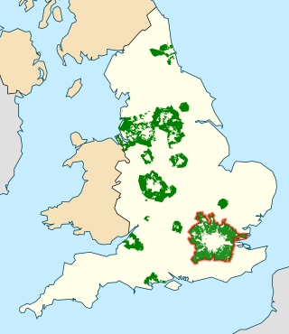
The Metropolitan Green Belt is a statutory green belt around London, England. It comprises parts of Greater London, Berkshire, Buckinghamshire, Essex, Hertfordshire, Kent and Surrey, parts of two of the three districts of Bedfordshire and a small area in Copthorne, Sussex. As of 2017/18, Government statistics show the planning designation covered 513,860 hectares of land.
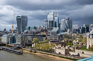
Greater London is the administrative area of London, England, coterminous with the London region. It contains 33 local government districts: the 32 London boroughs, which form a ceremonial county also called Greater London, and the City of London. The Greater London Authority is responsible for strategic local government across the region, and regular local government is the responsibility of the borough councils and the City of London Corporation. Greater London is bordered by the ceremonial counties of Hertfordshire to the north, Essex to the north-east, Kent to the south-east, Surrey to the south, and Berkshire and Buckinghamshire to the west.


