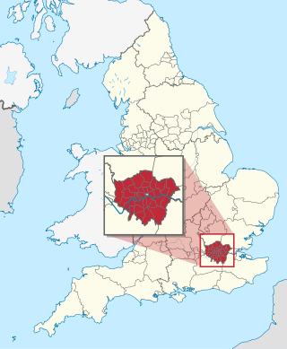
The London boroughs are the 32 local authority districts that together with the City of London make up the administrative area of Greater London, England; each is governed by a London borough council. The present London boroughs were all created at the same time as Greater London on 1 April 1965 by the London Government Act 1963 and are a type of local government district. Twelve were designated as Inner London boroughs and twenty as Outer London boroughs. The City of London, the historic centre, is a separate ceremonial county and sui generis local government district that functions quite differently from a London borough. However, the two counties together comprise the administrative area of Greater London as well as the London Region, all of which is also governed by the Greater London Authority, under the Mayor of London.

Southwark is a district of Central London situated on the south bank of the River Thames, forming the north-western part of the wider modern London Borough of Southwark. The district, which is the oldest part of South London, developed due to its position at the southern end of the early versions of London Bridge, for centuries the only dry crossing on the river. Around 43 AD, engineers of the Roman Empire found the geographic features of the south bank here suitable for the placement and construction of the first bridge.

Bermondsey is a district in southeast London, part of the London Borough of Southwark, England, 2.5 miles (4.0 km) southeast of Charing Cross. To the west of Bermondsey lies Southwark, to the east Rotherhithe and Deptford, to the south Walworth and Peckham, and to the north is Wapping across the River Thames. It lies within the historic county boundaries of Surrey. During the Industrial Revolution Bermondsey became a centre for manufacturing, particularly in relation to tanning. More recently it has experienced regeneration including warehouse conversions to flats and the provision of new transport links.

The London Borough of Southwark in South London forms part of Inner London and is connected by bridges across the River Thames to the City of London and London Borough of Tower Hamlets. It was created in 1965 when three smaller council areas amalgamated under the London Government Act 1963. All districts of the area are within the London postal district. It is governed by Southwark London Borough Council.
The Metropolitan Borough of Southwark was a metropolitan borough in the County of London from 1900 to 1965. It was created to cover the western section of the ancient borough of Southwark and the parish of Newington. In common with the rest of inner London, the borough experienced a steady decline in population throughout its existence. The borough council made an unsuccessful attempt to gain city status in 1955. Its former area is now the northwestern part of the current London Borough of Southwark.

The County of London was a county of England from 1889 to 1965, corresponding to the area known today as Inner London. It was created as part of the general introduction of elected county government in England, by way of the Local Government Act 1888. The Act created an administrative County of London, which included within its territory the City of London. However, the City of London and the County of London formed separate ceremonial counties for "non-administrative" purposes. The local authority for the county was the London County Council (LCC), which initially performed only a limited range of functions, but gained further powers during its 76-year existence. The LCC provided very few services within the City of London, where the ancient Corporation monopolised local governance. In 1900, the lower-tier civil parishes and district boards were replaced with 28 new metropolitan boroughs. The territory of the county was 74,903 acres (303.12 km2) in 1961. During its existence, there was a long-term decline in population as more residents moved into the outer suburbs; there were periodic reviews of the local government structures in the greater London area and several failed attempts to expand the boundaries of the county. In 1965, the London Government Act 1963 replaced the county with the much larger Greater London administrative area.
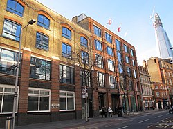
Tooley Street is a road in central and south London connecting London Bridge to St Saviour's Dock; it runs past Tower Bridge on the Southwark/Bermondsey side of the River Thames, and forms part of the A200 road.

The London Government Act 1963 is an act of the Parliament of the United Kingdom, which created Greater London and a new local government structure within it. The Act significantly reduced the number of local government districts in the area, resulting in local authorities responsible for larger areas and populations. The upper tier of local government was reformed to cover the whole of the Greater London area and with a more strategic role; and the split of functions between upper and lower tiers was recast. The Act classified the boroughs into inner and outer London groups. The City of London and its corporation were essentially unreformed by the legislation. Subsequent amendments to the Act have significantly amended the upper tier arrangements, with the Greater London Council abolished in 1986, and the Greater London Authority introduced in 2000. As of 2016, the London boroughs are more or less identical to those created in 1965, although with some enhanced powers over services such as waste management and education.

Bermondsey and Old Southwark is a constituency in the House of Commons of the UK Parliament. Since 2015, it has been represented by Neil Coyle, who was elected as a Labour MP but was suspended from the party from 2022 to 2023 following an accusation of racism.

Hackney London Borough Council, also known as Hackney Council, is the local authority for the London Borough of Hackney, in Greater London, England. It is a London borough council, one of 32 in London. The council has been under Labour majority control since 2002. Since 2002 the council has been led by a directly elected mayor. The council meets at Hackney Town Hall and has its main offices in the adjoining Hackney Service Centre.

Islington London Borough Council, also known as Islington Council, is the local authority for the London Borough of Islington in Greater London, England. It is a London borough council, one of 32 in London. The council has been under Labour majority control since 2010. The council meets at Islington Town Hall.
Bermondsey was a parish in the metropolitan area of London, England.
The Royal Commission on Local Government in Greater London, also known as the Herbert Commission, was established in 1957 and published its report in 1960. The report made recommendations for the overhaul of the administration of the capital. They were modified and implemented by the London Government Act 1963.

Tower Hamlets London Borough Council, also known as Tower Hamlets Council, is the local authority for the London Borough of Tower Hamlets in Greater London, England. It is a London borough council, one of 32 in London. The council has been under the majority control of local party Aspire since 2022. It has been led by a directly elected mayor since 2010. The council is based at Tower Hamlets Town Hall on Whitechapel Road.
The 1964 Southwark Council election took place on 7 May 1964 to elect members of Southwark London Borough Council in London, England. The whole council was up for election and the Labour party gained control of the council.
Kensington and Chelsea London Borough Council, also known as Kensington and Chelsea Council, is the local authority for the Royal Borough of Kensington and Chelsea in Greater London, England. It is a London borough council, one of 32 in London. The council has been under Conservative majority control since its creation in 1965. It is based at Kensington Town Hall.
Greenwich London Borough Council, also known as Greenwich Council or the Council of the Royal Borough of Greenwich, is the local authority for the Royal Borough of Greenwich in Greater London, England. It is a London borough council, one of 32 in London. The council has been under Labour majority control since 1971. It meets at Woolwich Town Hall and has its main offices at the Woolwich Centre opposite.
Wandsworth London Borough Council, also known as Wandsworth Council, is the local authority for the London Borough of Wandsworth in Greater London, England. It is a London borough council, one of 32 in London. The council has been under Labour majority control since 2022. It is based at Wandsworth Town Hall in the centre of Wandsworth.
Hammersmith and Fulham London Borough Council, which styles itself Hammersmith and Fulham Council, is the local authority for the London Borough of Hammersmith and Fulham in Greater London, England. It is a London borough council, one of 32 in London. The council has been under Labour majority control since 2014. The council's usual meeting place is at Hammersmith Town Hall.

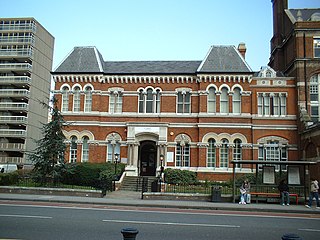
Camberwell Town Hall is a municipal building in Peckham Road, Camberwell, London, England.