
Mandurah is a coastal city in the Australian state of Western Australia, situated approximately 72 kilometres (45 mi) south of the state capital, Perth. It is the state's second most populous city, with a population of 90,306.

Pinjarra is a town in the Peel region of Western Australia along the South Western Highway, 82 kilometres (51 mi) from the state capital, Perth and 21 kilometres (13 mi) south-east of the coastal city of Mandurah. Its local government area is the Shire of Murray. At the 2016 census, Pinjarra had a population of 4910.

Safety Bay is an outer southern suburb of Perth, the capital city of Western Australia, located on the coast within the City of Rockingham.
Coodanup is a south-eastern suburb of Mandurah, Western Australia. Its local government area is the City of Mandurah.
Greenfields is a suburb east of Mandurah, located east of Mandurah's central area. It includes several aged care residences and a large recreation oval and centre.

Dawesville is a Legislative Assembly electorate in the state of Western Australia. Dawesville is named for the southwestern Mandurah suburb of Dawesville, which falls within its borders.

Murray-Wellington is an electoral district of the Legislative Assembly in the Australian state of Western Australia. The seat's current member is Labor MLA Robyn Clarke.

Lake Clifton is a small town located on the east side of the lake of the same name in the Peel region of Western Australia just off the Old Coast Road, between Mandurah and Bunbury at the north end of the Yalgorup National Park. At the 2021 census, Lake Clifton had a population of 759.

Preston Beach is a small town located in the Peel region of Western Australia just off the Forrest Highway, between Mandurah and Bunbury in the Yalgorup National Park.

The City of Mandurah is a local government area of Western Australia, covering both Mandurah proper and an additional area reaching down as far south as Lake Clifton. The city has a total area of approximately 174 square kilometres (67 sq mi).

Herron is a small suburb located in the Peel region of Western Australia just off the Old Coast Road, between Mandurah and Bunbury just beyond Mandurah's urban area. It is on a narrow strip between Lake Clifton and Yalgorup National Park to the west, and Harvey Estuary to the east.

The Peel-Harvey Estuarine System is a natural estuarine system that lies roughly parallel to the coast of Western Australia and south of the town of Mandurah.

Barragup is a locality near Mandurah, Western Australia, located north of Pinjarra Road and east of the Serpentine River within the Shire of Murray. Its postcode is 6209. At the 2016 census, Barragup had a population of 806.

Forrest Highway is a 95-kilometre-long (59 mi) highway in Western Australia's Peel and South West regions, extending Perth's Kwinana Freeway from east of Mandurah down to Bunbury. Old Coast Road was the original Mandurah–Bunbury route, dating back to the 1840s. Part of that road, and the Australind Bypass around Australind and Eaton, were subsumed by Forrest Highway. The highway begins at Kwinana Freeway's southern terminus in Ravenswood, continues around the Peel Inlet to Lake Clifton, and heads south to finish at Bunbury's Eelup Roundabout. There are a number of at-grade intersections with minor roads in the shires of Murray, Waroona, and Harvey including Greenlands Road and Old Bunbury Road, both of which connect to South Western Highway near Pinjarra.

Ravenswood is a small town in the Peel region of Western Australia.

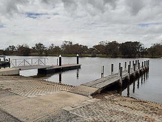
South Yunderup is a township near Mandurah, Western Australia, located on the south bank of the Murray River within the Shire of Murray. Its postcode is 6208, and in the 2011 Census, it had a population of 2,235 with a median age of 50. South Yunderup is also the second-largest township in the Shire of Murray after the main town, Pinjarra.

Furnissdale is a locality near Mandurah, Western Australia, to the south of Pinjarra Road and near the Serpentine River entrance into the Peel Inlet within the Shire of Murray. Its postcode is 6209. At the 2011 census, Furnissdale had a population of 1,027.
Pinjarra Senior High School is an independent high school in Pinjarra, a regional centre 86 kilometres (53 mi) south of Perth, Western Australia. The school district covers the Pinjarra and surrounding areas such as Serpentine, Dwellingup, Waroona, North Yunderup and South Yunderup.

Clifton is a small uninhabited locality located in the Peel region of Western Australia, between Mandurah and Bunbury. Adjoining the nearby suburb of Herron. It lies on a narrow strip between Lake Clifton and Yalgorup National Park to the east, and the Indian Ocean to the west.
Mandurah is the central suburb of the city of Mandurah in Western Australia's Peel region. At the 2016 census, it had a population of 7,837.