This List of Bays of Outer Hebrides summarises the bays that are located on the islands of the Outer Hebrides in Scotland.
Seaforth Island located in Loch Seaforth has no bays.
Name | County | Nearest Village | Coordinates | Notes |
---|---|---|---|---|
Bàgh | Ross and Cromarty | 57°59′55″N6°25′44″W / 57.9985°N 6.4289°W | ||
Puill chriadha | Ross and Cromarty | 58°00′08″N6°26′53″W / 58.0023°N 6.4480°W | ||
Tob Sgarbh Sgeir | Ross and Cromarty | 57°59′50″N6°25′08″W / 57.9973°N 6.4189°W | ||
Tob Rubha na Caora Duibhe | Ross and Cromarty | 57°59′53″N6°26′31″W / 57.9980°N 6.4420°W |
Name | County | Nearest Village | Coordinates | Notes |
---|---|---|---|---|
Camas Leire Geodha | Ross and Cromarty | 58°04′54″N7°07′58″W / 58.081798°N 7.132833°W | ||
The inshore island of Eilean Chaluim Chille in the Loch Erisort sea loch, has no bays.
The small island of Ceabhaigh, located in the outer part of the Loch Ròg sea loch, has no bays.
The small island of Eilean Chearstaidh, located in inner part of the Loch Ròg sea loch, has no bays.
The small off-shore island of Flodaigh has no bays.
The small island of Fuaigh Beag has no bays.
The small island of Fuaigh Mòr has no bays.
The small island of Little Bernera (Scottish Gaelic : Beàrnaraigh Beag) has no bays.
The uninhabited island of Pabaigh Mòr has no bays.
Name | County | Nearest Village | Coordinates | Notes |
---|---|---|---|---|
Bàgh Tòb a' Mhorghain | Inverness-shire | 58°13′55″N6°55′04″W / 58.231932°N 6.917694°W | ||
Tòb an T-Seann Bhaile | Inverness-shire | 58°13′41″N6°55′09″W / 58.228008°N 6.919196°W |
Name | County | Nearest Town | Coordinates | Notes |
---|---|---|---|---|
Bàgh Alairip | Na h-Eileanan an Iar | 57°46′58″N7°14′29″W / 57.78279877°N 7.24130234°W | ||
The island of Scarp (Scottish Gaelic : An Sgarp), west of Hushinish on Harris has no bays.
The tiny island of Soay Mòr (Scottish Gaelic : Sòdhaigh Mòr) in West Loch Tarbert has no bays.
The uninhabited Stockinish Island (Scottish Gaelic : Eilean Stocainis) off the coast of Harris has no bays.
The small uninhabited island of Eilean Chearstaidh in Loch Roag has no bays.
There are two "Flodday"s near Barra. One is in the Barra Isles at grid reference NL612924, the other in the Sound of Barra to the north at grid reference NF751022. The island of Flodday in the Barra Isles group at 56°53′55″N7°34′01″W / 56.898653°N 7.567038°W has no bays. The island of Flodday in the Sound of Barra at 56°53′55″N7°34′01″W / 56.898653°N 7.567038°W has no bays.
The small low-lying island of Ceallasaigh Beag had no bays.
The small low-lying island of Ceallasaigh Mòr had no bays
Name | County | Nearest Village | Coordinates | Notes |
---|---|---|---|---|
Port Ruadh | Inverness-shire | 57°31′09″N7°36′36″W / 57.51919937°N 7.61011919°W | ||
Seana Phort | Inverness-shire | 57°31′27″N7°36′05″W / 57.52420044°N 7.60136808°W | ||
Name | County | Nearest Village | Coordinates | Notes |
---|---|---|---|---|
Croic | Inverness-shire | 57°31′49″N7°38′41″W / 57.53020096°N 7.64472108°W | ||
Name | County | Nearest Village | Coordinates | Notes |
---|---|---|---|---|
Bàgh Chlann Neill | Ross and Cromarty | 57°54′05″N6°19′56″W / 57.90150070°N 6.33211563°W | [15] | |
Bàgh Hacanais | Ross and Cromarty | 57°31′24″N7°38′53″W / 57.523337°N 7.647937°W |
The small island Garbh Eilean in the Shiant Islands group have no bays.
Name | County | Nearest Village | Coordinates | Notes |
---|---|---|---|---|
An Acairseid | Inverness-shire | Bruernish | 56°59′01″N7°22′41″W / 56.98369980°N 7.37814055°W | |
Bàgh Beag | Inverness-shire | Castlebay | 56°56′57″N7°30′06″W / 56.94929886°N 7.501777302°W | |
Bàgh Halaman | Inverness-shire | Borve | 56°58′27″N7°31′42″W / 56.97430038°N 7.52843332°W | [16] |
Bàgh nan Clach | Inverness-shire | Eoligarry | 57°02′50″N7°27′10″W / 57.04719925°N 7.45281963°W | |
Castlebay | Inverness-shire | Castlebay | 56°56′47″N7°29′01″W / 56.94649887°N 7.48357337°W | [17] |
Name | County | Nearest Town | Coordinates | Notes |
---|---|---|---|---|
Sloc an Ime | Inverness-shire | 56°46′47″N7°37′49″W / 56.77970123°N 7.63019242°W | ||
Sloc Greiligeo | Inverness-shire | 56°46′43″N7°38′04″W / 56.77870178°N 7.63440212°W | ||
Sloc Veacligeo | Inverness-shire | 56°46′45″N7°38′28″W / 56.77920151°N 7.64121129°W | ||
Sloc Ceann a' Ghàrraidh | Inverness-shire | 56°46′50″N7°37′37″W / 56.78049850°N 7.62688346°W | ||
The small island of Flodday, located to the south of Vatersay has no bays.
The small island of Lingeigh has no bays.
Name | County | Nearest Town | Coordinates | Notes |
---|---|---|---|---|
Bàgh na h-Aoineig | Inverness-shire | 56°48′44″N7°39′19″W / 56.81230164°N 7.65527719°W | [18] | |
Bàgh Hunadudh | Inverness-shirer | 56°49′26″N7°37′11″W / 56.82389832°N 7.61986102°W | ||
Bàgh Mhiùghlaigh | Inverness-shire | 56°48′40″N7°37′24″W / 56.81110001°N 7.62323293°W | [18] | |
Bàgh Slèiteadh | Inverness-shire | 56°49′22″N7°38′53″W / 56.82270050°N 7.64806197°W | ||
Bay Analepp | Inverness-shire | 56°49′32″N7°37′58″W / 56.82550049°N 7.63282530°W | ||
Sloc Dubh an Dùin | Inverness-shire | 56°48′02″N7°39′35″W / 56.80059814°N 7.65975145°W | ||
Sloc Hèisegeo | Inverness-shire | 56°47′56″N7°39′21″W / 56.79890060°N 7.65573234°W | ||
The small uninhabited island of Muldoanich (Gaelic: Maol Dòmhnaich) has no bays.
Name | County | Nearest Town | Coordinates | Notes |
---|---|---|---|---|
Bàgh Bàn | Inverness-shire | 56°51′03″N7°33′34″W / 56.85089874°N 7.55952490°W | ||
Sloc Grànda | Inverness-shire | 56°51′33″N7°35′05″W / 56.85910034°N 7.58460377°W | ||
Sloc Glamairidhgeo | Inverness-shire | 56°50′56″N7°34′53″W / 56.84880066°N 7.58134699°W | ||
Sloc Glansaich | Inverness-shire | 56°51′20″N7°35′33″W / 56.85549927°N 7.59254933°W | ||
Name | County | Nearest Town | Coordinates | Notes |
---|---|---|---|---|
Bàgh Bàn | Inverness-shire | 56°53′59″N7°30′14″W / 56.899842°N 7.503962°W | ||
Name | County | Nearest Town | Coordinates | Notes |
---|---|---|---|---|
Bàgh Chornaig | Inverness-shire | Baile Bhatarsaigh | 56°56′25″N7°31′39″W / 56.94020081°N 7.52750785°W | [19] |
Bàgh Bhatarsaigh | Inverness-shire | Baile Bhatarsaigh | 56°55′39″N7°30′38″W / 56.92760086°N 7.51051768°W | [19] |
Bàgh a' Deas | Inverness-shire | Baile Bhatarsaigh | 56°54′42″N7°31′38″W / 56.91170120°N 7.52730050°W | |
Bàgh Siar | Inverness-shire | Baile Bhatarsaigh | 56°55′33″N7°33′14″W / 56.92570114°N 7.55400458°W | [20] |
Name | County | Nearest Village | Coordinates | Notes |
---|---|---|---|---|
Bàgh an Tobair | Inverness-shire | Balivanich | 57°32′01″N7°20′45″W / 57.53359985°N 7.34586168°W | |
Bàgh Leachdach | Inverness-shire | 57°32′29″N7°22′06″W / 57.54150009°N 7.36842900°W | ||
Bàgh Salach | Inverness-shire | 57°31′52″N7°20′42″W / 57.53099823°N 7.34486679°W |
Name | County | Nearest Village | Coordinates | Notes |
---|---|---|---|---|
Bàgh na Muice | Inverness-shire | Balivanich | 57°28′04″N7°14′04″W / 57.467785°N 7.234520°W | |
Bàgh Hiùrabhagh | Inverness-shire | 57°26′19″N7°16′12″W / 57.43849945°N 7.26997336°W | ||
Bàgh a' Bhràoige | Inverness-shire | 57°24′32″N7°12′14″W / 57.40900040°N 7.20375238°W | ||
Bàgh Niabhag | Inverness-shire | 57°26′57″N7°14′45″W / 57.44929886°N 7.24585163°W | ||
Bàgh Sgaraileòd | Inverness-shire | 57°26′40″N7°14′55″W / 57.44440079°N 7.24861461°W | ||
Cula | Inverness-shire | 57°27′35″N7°24′18″W / 57.45959854°N 7.40490595°W | ||
Name | County | Nearest Village | Coordinates | Notes |
---|---|---|---|---|
Sloc Liath | Inverness-shire | 57°03′38″N7°16′58″W / 57.06060028°N 7.28288916°W | ||
The tidal island of Flodaigh, lying to the north of Benbecula has no bays.
The tidal island of Fraoch-Eilean has no bays.
Name | County | Nearest Town | Coordinates | Notes |
---|---|---|---|---|
Bàgh Dubh | Inverness-shire | 57°29′05″N7°14′12″W / 57.48479843°N 7.23667899°W | ||
Bàgh Sgotbheinn | Inverness-shire | 57°28′57″N7°14′03″W / 57.48260117°N 7.23421850°W | ||
Bàgh Mhic Rath | Inverness-shire | 57°28′57″N7°14′03″W / 57.48260117°N 7.23421850°W | ||
The tidal island of Grimsay (South) has no bays.
Name | County | Nearest Village | Coordinates | Notes |
---|---|---|---|---|
Breivik | Inverness-shire | 57°42′42″N7°16′39″W / 57.71170044°N 7.27736469°W | ||
The island of Flodaigh Mòr of the shore at the northeastern end of Ronay has no bays.
The tidal island of Kirkibost, located within the coast in the south-west corner of North Uist, has no bays.
The tidal islands of Oronsay, located in the north coast North Uist has no bays.
Name | County | Nearest Town | Coordinates | Notes |
---|---|---|---|---|
Acairseid Fhalaich | Inverness-shire | 57°29′51″N7°10′08″W / 57.49739838°N 7.16895256°W | ||
Bàgh an Eireannach | Inverness-shire | 57°29′37″N7°09′43″W / 57.49369812°N 7.16190318°W | ||
Bàgh Clann Nèill | Inverness-shire | 57°29′00″N7°11′49″W / 57.48329926°N 7.19707063°W | ||
Bàgh na Caiplich | Inverness-shire | 57°29′18″N7°10′11″W / 57.48839951°N 7.16975258°W | ||
Bàgh nan Uamh | Inverness-shire | 57°30′00″N7°11′49″W / 57.50009918°N 7.19689227°W | [14] | |
Bàgh Rubha Chnaip | Inverness-shire | 57°29′17″N7°12′16″W / 57.48809814°N 7.20440162°W | ||
Camas Mòr | Inverness-shire | 57°28′19″N7°11′10″W / 57.47190094°N 7.18620749°W | ||
The small island of Shillay has no bays.
Name | County | Nearest Town | Coordinates | Notes |
---|---|---|---|---|
Bàgh Clann Neill | Inverness-shire | Sollas | 57°39′21″N7°26′08″W / 57.65579987°N 7.43558604°W | |
Bàgh nan Craobhag | Inverness-shire | Sollas | 57°39′56″N7°24′58″W / 57.66550064°N 7.41624461°W | [21] |
Camas na Crìche | Inverness-shire | Sollas | 57°39′42″N7°25′52″W / 57.66159821°N 7.43104117°W |
The small islands of Calbhaigh, that contains the remains of Calvay Castle has no bays.
Name | County | Nearest Town | Coordinates | Notes |
---|---|---|---|---|
Bàgh Mhic Rois | Inverness-shire | Lochboisdale | 57°08′34″N7°18′36″W / 57.14289856°N 7.31011799°W | |
The small offshore island of Stuley (Gaelic:Stulaigh) has no bays
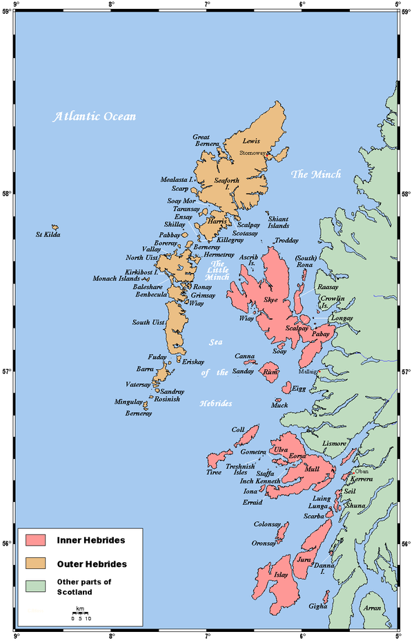
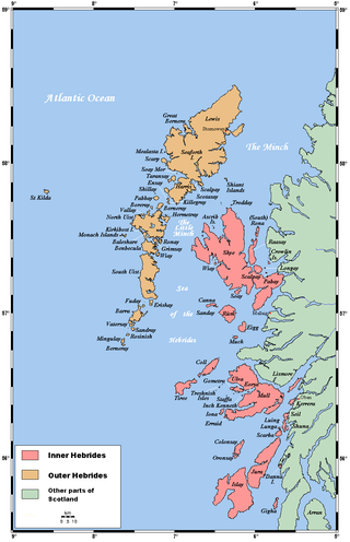
The Hebrides are an archipelago off the west coast of the Scottish mainland. The islands fall into two main groups, based on their proximity to the mainland: the Inner and Outer Hebrides.
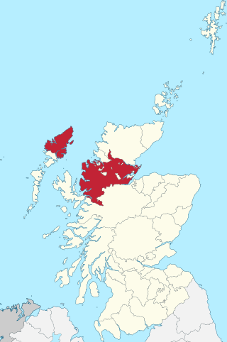
The Outer Hebrides or Western Isles, sometimes known as the Long Isle/Long Island, is an island chain off the west coast of mainland Scotland. The islands are geographically coextensive with Comhairle nan Eilean Siar, one of the 32 unitary council areas of Scotland. They form part of the archipelago of the Hebrides, separated from the Scottish mainland and from the Inner Hebrides by the waters of the Minch, the Little Minch, and the Sea of the Hebrides. Scottish Gaelic is the predominant spoken language, although in a few areas English speakers form a majority.
Harris is the southern and more mountainous part of Lewis and Harris, the largest island in the Outer Hebrides, Scotland. Although not an island itself, Harris is often referred to in opposition to the Isle of Lewis as the Isle of Harris, which is the former postal county and the current post town for Royal Mail postcodes starting HS3 or HS5.
Benbecula is an island of the Outer Hebrides in the Atlantic Ocean off the west coast of Scotland. In the 2011 census, it had a resident population of 1,283 with a sizable percentage of Roman Catholics. It is in a zone administered by Comhairle nan Eilean Siar or the Western Isles Council. The island is about 12 kilometres from west to east and a similar distance from north to south. It lies between the islands of North Uist and South Uist and is connected to both by road causeways. Benbecula's main settlement and administrative centre is Balivanich.
Grimsay is a tidal island in the Outer Hebrides of Scotland.
"Uist" is a group of six islands and are part of the Outer Hebridean Archipelago, part of the Outer Hebrides of Scotland.
Ross-shire is a historic county in the Scottish Highlands. The county borders Sutherland to the north and Inverness-shire to the south, as well as having a complex border with Cromartyshire – a county consisting of numerous enclaves or exclaves scattered throughout Ross-shire's territory. Ross-shire includes most of Ross along with Lewis in the Outer Hebrides. Dingwall is the traditional county town. The area of Ross-shire is based on that of the historic province of Ross, but with the exclusion of the many enclaves that form Cromartyshire.
Ceann a' Ghàraidh is the location of the ferry terminal on the south-western side of the island of Eriskay in the Outer Hebrides of Scotland. It provides a service across the Sound of Barra to Ardmore on the island of Barra The placename literally means "The head of the garden". This location is so called due to the presence of the old crofting boundary walls, which can no longer be seen.
The Hebrides were settled early on in the settlement of the British Isles, perhaps as early as the Mesolithic era, around 8500–8250 BC, after the climatic conditions improved enough to sustain human settlement. There are examples of structures possibly dating from up to 3000 BC, the finest example being the standing stones at Callanish, but some archaeologists date the site as Bronze Age. Little is known of the people who settled in the Hebrides but they were likely of the same Celtic stock that had settled in the rest of Scotland. Settlements at Northton, Harris, have both Beaker & Neolithic dwelling houses, the oldest in the Western Isles, attesting to the settlement.
There are many small islands in Scotland called Flodday or similar and this list provides a guide to their location. The derivation of the name is from the Old Norse floti meaning "raft" or "float". The similar island names Fladda and Flotta are also from the Norse flatr and mean "flat island". Usage is not always consistent in external sources.
Lewis and Harris, or Lewis with Harris, is a single Scottish island in the Outer Hebrides, divided by mountains. It is the largest island in Scotland and the third largest in the British Isles, after Great Britain and the island of Ireland, with an area of 841 square miles (2,178 km2), which is approximately 1% of the area of Great Britain. The northern two-thirds is called [the Isle of] Lewis and the southern third [the Isle of] Harris; each is referred to as if it were a separate island and there are many cultural and linguistic differences between the two.
Inverness-shire is a historic county, registration county and lieutenancy area of Scotland. Covering much of the Highlands and Outer Hebrides, it is Scotland's largest county, though one of the smallest in population, with 67,733 people or 1.34% of the Scottish population.
Bearasaigh or Bearasay is an islet in outer Loch Ròg, Lewis, Scotland. During the late 16th and early 17th centuries it was used as a pirates' hideout and the remains of various buildings from that period still exist. In the modern era its cliffs are used for rock-climbing.
Port Stoth, known locally as Stoth and pronounced Stow, is a sheltered inlet just southeast of the Butt of Lewis in the Outer Hebrides, Scotland. It is the most northerly landing in the Outer Hebrides. A track leads down to a slipway which runs across the sandy beach.