List of crossings of the Hudson River

Last updated

The Holland Tunnel is one of America's busiest tunnels. Holland tunnel.jpg
The Holland Tunnel is one of America's busiest tunnels.

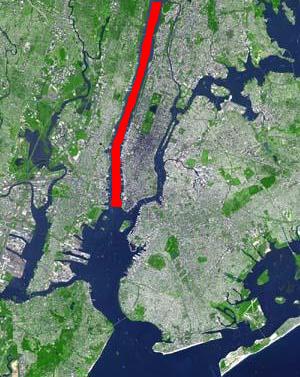
This is a list of bridges and other crossings of the Hudson River , from its mouth at the Upper New York Bay upstream to its cartographic beginning at Henderson Lake in Newcomb, New York.

Contents

Crossings

The crossings are listed from south to north.

CrossingCarriesLocationBuiltCoordinatesImageTolls
New Jersey – New York
Downtown Hudson Tubes Port Authority Trans-Hudson PATH Jersey CityManhattan 1909
Holland Tunnel I-78.svgEllipse sign 139.svg I-78  / Route 139 1927 40°43′39″N74°01′16″W / 40.72750°N 74.02111°W / 40.72750; -74.02111 Holland Tunnel Eastbound.jpg $17.00 (eastbound)
Uptown Hudson Tubes Port Authority Trans-Hudson PATH 1908
North River Tunnels Amtrak and New Jersey Transit North BergenManhattan 1910 40°45′32″N74°00′46″W / 40.75889°N 74.01278°W / 40.75889; -74.01278
Lincoln Tunnel Ellipse sign 495.svgNY-495.svg Route 495  / NY 495 WeehawkenManhattan 1937 (Center Tube)
1945 (North Tube)
1957 (South Tube)
40°45′47″N74°00′36″W / 40.76306°N 74.01000°W / 40.76306; -74.01000 $17.00 (eastbound)
George Washington Bridge I-95.svgUS 1-9.svgUS 46.svg I-95  / US 1-9  / US 46  / BR 9 Fort LeeManhattan 1931 (Upper Level)
1962 (Lower Level)
40°51′05″N73°57′09″W / 40.85139°N 73.95250°W / 40.85139; -73.95250 George Washington Bridge from New Jersey-edit.jpg $17.00 (eastbound)
New York
Tappan Zee Bridge I-87.svgI-287.svgNYS Thruway Sign.svg I-87  / I-287  / New York Thruway South NyackTarrytown 1955-2017 (demolished) 41°04′12″N73°53′40″W / 41.07000°N 73.89444°W / 41.07000; -73.89444 TappanZeeBridgeFromBelow.JPG
New Tappan Zee Bridge 2017 (Westbound) 2018 (Eastbound) 41°04′17″N73°53′40″W / 41.07139°N 73.89444°W / 41.07139; -73.89444 Tappan Zee Bridge 2019c.jpg $7.48 (eastbound)
Bear Mountain Bridge US 6.svgUS 202 (NY).svg US 6  / US 202  / Appalachian Trail  / BR 9 HighlandsCortlandt 1924 41°19′11″N73°59′00″W / 41.31972°N 73.98333°W / 41.31972; -73.98333 Bear Mountain Bridge, NY from river level loking East.JPG $1.50 (eastbound)
Newburgh–Beacon Bridge I-84.svgNY-52.svg I-84  / NY 52 NewburghBeacon 1963 (westbound)
1980
41°31′11″N73°59′50″W / 41.51972°N 73.99722°W / 41.51972; -73.99722 Newburgh-Beacon Bridge 2.jpg $1.50 (eastbound)
Mid-Hudson Bridge US 44.svgNY-55.svg US 44  / NY 55 LloydPoughkeepsie 1930 41°42′10″N73°56′45″W / 41.70278°N 73.94583°W / 41.70278; -73.94583 Mid-Hudson Bridge 2010-03-07.JPG $1.50 (eastbound)
Poughkeepsie Railroad Bridge Former railroad bridge, now pedestrian/bicycle HighlandPoughkeepsie 1889 (rail)
2009 (pedestrian)
41°42′37″N73°56′22″W / 41.71028°N 73.93944°W / 41.71028; -73.93944 Poughkeepsie Railroad Bridge 20071020.jpg
Kingston-Rhinecliff Bridge NY-199.svg NY 199 UlsterRhinebeck 1957 41°58′38″N73°56′43″W / 41.97722°N 73.94528°W / 41.97722; -73.94528 Breaking The Ice On The Hudson River With United States Coast Guard Cutter Hawser -v.jpg $1.50 (eastbound)
Rip Van Winkle Bridge NY-23.svg NY 23 CatskillGreenport 1935 42°13′24″N73°51′01″W / 42.22333°N 73.85028°W / 42.22333; -73.85028 Rip Van Winkle Bridge.JPG $1.50 (eastbound)
Alfred H. Smith Memorial Bridge CSX Castleton Subdivision SelkirkCastleton-on-Hudson 1924 42°30′31″N73°46′30″W / 42.50861°N 73.77500°W / 42.50861; -73.77500 Smith Memorial Bridge 20091020.jpg
Castleton Bridge NYS Thruway Sign.svg Berkshire Connector CoeymansSchodack 1959 42°30′33″N73°46′24″W / 42.50917°N 73.77333°W / 42.50917; -73.77333 Castleton Bridge 20091020.jpg $1.05 (both directions, tolled as part of Thruway cost)
Maiden Lane Bridge (demolished 1960s)Rail AlbanyRensselaer 1871
Dunn Memorial Bridge US 9.svgUS 20.svg US 9  / US 20 1969 42°38′35″N73°44′51″W / 42.64306°N 73.74750°W / 42.64306; -73.74750 Dunn Bridge 20091020.jpg
Hudson River Bridge (demolished)Rail
Livingston Avenue Bridge CSX Hudson Subdivision and Amtrak 1901 42°39′16″N73°44′30″W / 42.65444°N 73.74167°W / 42.65444; -73.74167 Livingston Bridge 20091020.jpg
Patroon Island Bridge I-90.svg I-90 1968 42°39′53″N73°43′44″W / 42.66472°N 73.72889°W / 42.66472; -73.72889 Patroon Island Bridge 20091020.jpg
Troy-Menands Bridge NY-378.svg NY 378 MenandsTroy 1933 42°42′04″N73°42′08″W / 42.70111°N 73.70222°W / 42.70111; -73.70222 Menands Bridge 20091022.jpg
Congress Street Bridge NY-2.svg NY 2 WatervlietTroy 1969 [1] 42°43′43″N73°41′50″W / 42.72861°N 73.69722°W / 42.72861; -73.69722 Congress Bridge 20091022.jpg
Green Island Bridge Green IslandTroy 1981 42°44′07″N73°41′23″W / 42.73528°N 73.68972°W / 42.73528; -73.68972 Green Island Troy Bridge 20091022-4086.jpg
Collar City Bridge NY-7.svg NY 7 1981 42°44′25″N73°41′18″W / 42.74028°N 73.68833°W / 42.74028; -73.68833 Collar City Bridge 20091022.jpg
112th Street Bridge NY-470.svg NY 470 CohoesTroy 1922
1996
42°46′17″N73°40′53″W / 42.77139°N 73.68139°W / 42.77139; -73.68139 112 Street Bridge 20091022.jpg
Troy-Waterford Bridge US 4.svg US 4 WaterfordTroy 1804 (original)
1909 (replaced)
42°47′19″N73°40′26″W / 42.78861°N 73.67389°W / 42.78861; -73.67389 Troy Waterford Bridge 20091022.jpg
Albany Northern Railroad Bridge (demolished)
Mechanicville Bridge NY-67.svg NY 67 MechanicvilleSchaghticoke 1888 (original)
1950 (replaced)
42°54′19″N73°40′57″W / 42.90528°N 73.68250°W / 42.90528; -73.68250
Rail bridge Pan Am Southern Railroad StillwaterSchaghticoke 42°55′10″N73°40′19″W / 42.91944°N 73.67194°W / 42.91944; -73.67194
Stillwater Bridge CR 125 jct.svgCR 125 jct.svg CR 125  / CR 125 StillwaterSchaghticoke 1930 42°56′16″N73°39′02″W / 42.93778°N 73.65056°W / 42.93778; -73.65056
Schuylerville Bridge NY-29.svg NY 29 SchuylervilleEaston 43°05′53″N73°34′25″W / 43.09806°N 73.57361°W / 43.09806; -73.57361
Dix BridgeCR 42 jct.svgCR 70 jct.svg CR 42  / CR 70 SchuylervilleGreenwich 1900 (original)
2013 (pedestrian) [2]
43°07′00″N73°34′53″W / 43.11667°N 73.58139°W / 43.11667; -73.58139
Hudson Valley Railway Bridge (demolished) NorthumberlandGreenwich 43°07′13″N73°34′50″W / 43.12028°N 73.58056°W / 43.12028; -73.58056
Greenwich and Johnsonville Railway Bridge (demolished) NorthumberlandGreenwich 43°07′17″N73°35′01″W / 43.12139°N 73.58361°W / 43.12139; -73.58361
Northumberland BridgeUS 4.svg US 4 NorthumberlandGreenwich 1917 43°07′43″N73°35′14″W / 43.12861°N 73.58722°W / 43.12861; -73.58722
Rail bridge Canadian Pacific Rail and Amtrak MoreauFort Edward 43°15′50″N73°35′21″W / 43.26389°N 73.58917°W / 43.26389; -73.58917
BridgeNY-197.svg NY 197 MoreauFort Edward 43°15′52″N73°35′25″W / 43.26444°N 73.59028°W / 43.26444; -73.59028
Sandy Hill Bridge
(abandoned)
South Glens FallsHudson Falls DETAIL, SECOND EAST ARCH, SOUTH SIDE, VIEW TO NORTH - Sandy Hill Bridge, Bridge Street, spanning Hudson River, Hudson Falls, Washington County, NY HAER NY,58-HUFA,1-4.tif
BridgeCR 27 jct.svg CR 27 43°17′50″N73°35′23″W / 43.29722°N 73.58972°W / 43.29722; -73.58972
Cooper's Cave BridgeUS 9.svgNY-32.svg US 9  / NY 32 South Glens FallsGlens Falls 2004 43°18′20″N73°38′28″W / 43.30556°N 73.64111°W / 43.30556; -73.64111
Saratoga-Queensbury BridgeI-87.svg I-87 MoreauQueensbury 43°15′48″N73°40′35″W / 43.26333°N 73.67639°W / 43.26333; -73.67639
Irving H. Densmore Memorial Bridge [3] CR 9 jct.svgCR 16 jct.svg CR 9  / CR 16 CorinthLake Luzerne 43°14′55″N73°49′56″W / 43.24861°N 73.83222°W / 43.24861; -73.83222
BridgeNY-9N.svg NY 9N HadleyLake Luzerne 43°18′17″N73°49′58″W / 43.30472°N 73.83278°W / 43.30472; -73.83278
County Road 44 BridgeCR 44 jct.svg CR 44 1931 [4] 43°19′00.9″N73°50′32.7″W / 43.316917°N 73.842417°W / 43.316917; -73.842417
Rail bridge (not in use)Former Delaware and Hudson Railroad line ThurmanWarrensburg 1905 [5] 43°28′43″N73°49′22″W / 43.47861°N 73.82278°W / 43.47861; -73.82278
Thurman Station Bridge NY-418.svg NY 418 ThurmanWarrensburg 1941 43°28′47″N73°49′06″W / 43.47972°N 73.81833°W / 43.47972; -73.81833 Thurman Station Bridge from Warrensburg.jpg
The Glen Bridge NY-28.svg NY 28 JohnsburgChester 1959 43°34′57″N73°51′36″W / 43.58250°N 73.86000°W / 43.58250; -73.86000 The Glen Bridge from Thurman shore.jpg
Riparius Bridge NY-8.svg NY 8 JohnsburgChester 2003 43°39′42″N73°53′53″W / 43.66167°N 73.89806°W / 43.66167; -73.89806 Hudson-River-at-Riparius-NY.jpg
North Creek Bridge NY-28N.svg NY 28N JohnsburgChester 1930 43°42′01″N73°58′59″W / 43.70028°N 73.98306°W / 43.70028; -73.98306 North Creek Bridge from Johnsburg shore.jpg
Adirondack Railway bridge Saratoga and North Creek Railroad 43°47′51″N74°03′05″W / 43.79750°N 74.05139°W / 43.79750; -74.05139
Finch Pruyn BridgePedestrian Newcomb 1993 [6] 43°53′40″N74°09′51″W / 43.89444°N 74.16417°W / 43.89444; -74.16417
Newcomb BridgeNY-28N.svg NY 28N Newcomb 43°57′57″N74°07′54″W / 43.96583°N 74.13167°W / 43.96583; -74.13167
BridgeCampsite Road Newcomb 43°58′08″N74°06′57″W / 43.96889°N 74.11583°W / 43.96889; -74.11583
BridgeCR 25 jct.svg CR 25 Newcomb 43°57′57″N74°03′00″W / 43.96583°N 74.05000°W / 43.96583; -74.05000
BridgeOpolescent Road Newcomb 44°00′58″N74°03′14″W / 44.01611°N 74.05389°W / 44.01611; -74.05389
BridgeCR 76 jct.svg CR 76 Tahawus 44°02′37″N74°03′29″W / 44.04361°N 74.05806°W / 44.04361; -74.05806
Fill with culvertsAdirondack Park Reserve Road Tahawus 44°03′04″N74°03′45″W / 44.05111°N 74.06250°W / 44.05111; -74.06250
Wooden foot bridge just east of Henderson Lake outletUpper Works Trail Tahawus 44°05′31″N74°03′28″W / 44.09194°N 74.05778°W / 44.09194; -74.05778 Upper Works footbridge.jpg

See also

Related Research Articles

<span class="mw-page-title-main">North River (Hudson River)</span> Section of the Hudson River between New York City and New Jersey

North River is an alternative name for the southernmost portion of the Hudson River in the vicinity of New York City and northeastern New Jersey in the United States.

<span class="mw-page-title-main">Bear Mountain Bridge</span> Bridge in United States of America

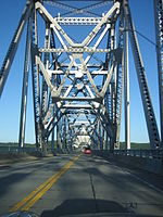
The Bear Mountain Bridge, ceremonially named the Purple Heart Veterans Memorial Bridge, is a toll suspension bridge in New York State. It carries US 6 and US 202 across the Hudson River between Bear Mountain State Park in Orange County and Cortlandt in Westchester County. At completion in 1924 it was the longest suspension bridge in the world until this record was surpassed 19 months later by the Benjamin Franklin Bridge between Philadelphia and Camden, New Jersey. The approach spans of the Bear Mountain Bridge are unsuspended trusses, like the Williamsburg Bridge in New York City, only its main span is suspended by cables.

<span class="mw-page-title-main">Timeline of Jersey City, New Jersey-area railroads</span>

For the purposes of this article, the Jersey City area extends North to Edgewater, South to Bayonne and includes Kearny Junction and Harrison but not Newark. Many routes east of Newark are listed here.

<span class="mw-page-title-main">Mid-Hudson Bridge</span> Bridge in New York and Poughkeepsie, New York

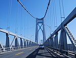
The Franklin Delano Roosevelt Mid-Hudson Bridge is a toll suspension bridge which carries US 44 and NY 55 across the Hudson River between Poughkeepsie and Highland in the state of New York.

<span class="mw-page-title-main">Saw Mill River Parkway</span>

The Saw Mill River Parkway is a north–south parkway that extends for 28.93 miles (46.56 km) through Westchester County, New York, in the United States. It begins at the border between Westchester County and the Bronx, as the continuation of the Henry Hudson Parkway leaving New York City, and heads generally northeastward to an interchange with Interstate 684 (I-684). At its north end, the parkway serves as a collector/distributor road as it passes east of the hamlet of Katonah. The parkway is named for the Saw Mill River, which the highway parallels for most of its length.

<span class="mw-page-title-main">Central Railroad of New Jersey Terminal</span> Former intermodal terminal in Jersey City, New Jersey

The Central Railroad of New Jersey Terminal, also known as Communipaw Terminal and Jersey City Terminal, was the Central Railroad of New Jersey's waterfront passenger terminal in Jersey City, New Jersey. The terminal was built in 1889, replacing an earlier one that had been in use since 1864. It operated until April 30, 1967.

<span class="mw-page-title-main">North River Tunnels</span> Rail tunnels in New York and New Jersey

The North River Tunnels are a pair of rail tunnels that carry Amtrak and New Jersey Transit passenger lines under the Hudson River between Weehawken, New Jersey, and Pennsylvania Station in Manhattan, New York City, New York. Built between 1904 and 1908 by the Pennsylvania Railroad (PRR) to allow its trains to reach Manhattan, they opened for service in late 1910.

Paterson Plank Road is a road that runs through Passaic, Bergen and Hudson Counties in northeastern New Jersey. The route, originally laid in the colonial era, connects the city of Paterson and the Hudson River waterfront. It has largely been superseded by Route 3, but in the many towns it passes it has remained an important local thoroughfare, and in some cases been renamed.

The Newark Plank Road was a major artery between Hudson Waterfront at Paulus Hook and city of Newark further inland across the New Jersey Meadows. As its name suggests, a plank road was constructed of wooden planks laid side-to-side on a roadbed. Similar roads, the Bergen Point Plank Road, the Hackensack Plank Road and Paterson Plank Road, traveled to the locales for which they are named. The name is no longer used, the route having been absorbed into other streets and freeways.

<span class="mw-page-title-main">Bergen Hill</span> Lower part of the Hudson Palisades, New Jersey, United States

Bergen Hill refers to the lower Hudson Palisades in New Jersey, where they emerge on Bergen Neck, which in turn is the peninsula between the Hackensack and Hudson Rivers, and their bays. In Hudson County, it reaches a height of 260 feet.

<span class="mw-page-title-main">Transportation on Long Island</span> Overview of transportation on Long Island

Nearly every major type of transportation serves Long Island, including three major airports, railroads and subways, and several major highways. The New York City Subway only serves the New York City boroughs of Brooklyn and Queens. There are historic and modern bridges, recreational and commuter trails, and ferries, that connect the boroughs of Queens and Brooklyn to Manhattan, the south shore with Fire Island and Long Island's north shore and east end with the state of Connecticut.

<span class="mw-page-title-main">Bergen Point Plank Road</span>

The Jersey City and Bergen Point Plank Road was a road originally built in the 19th century in Hudson County, New Jersey, United States which ran between Paulus Hook and Bergen Point. The company that built the road received a charter on March 6, 1850 to improve one that had been built in the 18th century. It has subsequently become Grand Street and Garfield Avenue in Jersey City and Broadway in Bayonne. Plank roads were built during the 19th century, often by private companies as turnpike roads, in this case with a tollgate at Communipaw Junction. As the name suggests, wooden boards were laid on a roadbed in order to prevent horse-drawn carriages and wagons from sinking into softer ground on the portions of the road.

<span class="mw-page-title-main">Newark and New York Railroad</span>

The Newark and New York Railroad was a passenger rail line that ran between Downtown Newark and the Communipaw Terminal at the mouth of the North River in Jersey City, bridging the Hackensack River and Passaic River just north of their mouths at the Newark Bay in northeastern New Jersey. The Central Railroad of New Jersey operated it from its opening in 1869. Though operations ended in 1946; portions remained in use until 1967.

<span class="mw-page-title-main">Port Imperial</span> Intermodal transit hub in Weehawken, New Jersey, US

Port Imperial is an intermodal transit hub on the Weehawken, New Jersey, waterfront of the Hudson River across from Midtown Manhattan, served by New York Waterway ferries and buses, Hudson–Bergen Light Rail, and NJT buses. The district lies under and at the foot of Pershing Road, a thoroughfare traveling along the face of the Hudson Palisades, which rise to its west. The Hudson River Waterfront Walkway runs along the shoreline and is abutted by recently constructed residential neighborhoods, Lincoln Harbor to the south and Bulls Ferry to the north.

The Newark Branch was a branch of the Erie Railroad in New Jersey, United States, running between Jersey City and Paterson and passing through the Broadway Section in North Newark, the origin of its name. Inaugurated in the 1870s, the line was last used for passenger service on September 30, 1966 but continues to be used for freight service on a portion of its length.

<span class="mw-page-title-main">Newark Drawbridge</span> Railroad bridge on the Passaic River between Newark and Harrison, New Jersey, U.S.

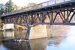
The Newark Drawbridge, also known as the Morristown Line Bridge, is a railroad bridge on the Passaic River between Newark and Harrison, New Jersey. The swing bridge is the 11th bridge from the river's mouth at Newark Bay and is 5.85 miles (9.41 km) upstream from it. Opened in 1903, it is owned and operated by New Jersey Transit.

<span class="mw-page-title-main">Lincoln Highway Hackensack River Bridge</span> Bridge in Jersey City and Kearny

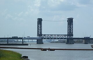
The Lincoln Highway Hackensack River Bridge is a vehicular vertical lift bridge crossing the Hackensack River at a point 1.8 mi (2.9 km) from the river mouth at Newark Bay in Hudson County, New Jersey, United States. The bridge, along the route of the Lincoln Highway, carries U.S. Route 1/9 Truck and the East Coast Greenway between the West Side of Jersey City and Kearny Point in Kearny. The most recent of many crossings at the location, the current bridge was completed in 1954. It is owned by and operated by the New Jersey Department of Transportation (NJDOT), and is required by the Title 33 of the Code of Federal Regulations to open on signal for maritime traffic. In 2007 it was designated the Shawn Carson and Robert Nguyen Memorial Bridge.

References

  1. "NY State Highway Bridge Data Albany County" (PDF). NYS Department of Transportatiom. June 30, 2023. Retrieved September 17, 2023.
  2. Leigh Hornbeck (July 22, 2010). "1900 span will be part of walking trail". Times Union. Retrieved August 28, 2012.
  3. "New York Highway - Article 6". Law and Legal Research. Retrieved July 6, 2013.
  4. "COUNTY ROAD 44 over HUDSON RIVER, Warren County, New York". bridgereports.com.
  5. Jon Patton (2008). "Railroad Bridges at Warrensburg, NY". The Adirondack Branch of the Delaware & Hudson Railroad. Retrieved August 28, 2012.
  6. Roger A. Dziengeleski (January 11, 1994). "Criticism of Finch, Pruyn Bridge Unjustified". The Daily Gazette. Retrieved August 28, 2012.
Map all coordinates using: OpenStreetMap