List of mines in British Columbia

Last updated

Map all coordinates using: OpenStreetMap  
Download coordinates as: KML

This is an incomplete list of mines in British Columbia , Canada and includes operating and closed mines, as well as proposed mines at an advanced stage of development (e.g. mining permits applied for). Mines that are in operation are in bold. Past producers which are under re-exploitation, re-development and/or re-promotion are in italics. Also in italics are major projects under development or subject to controversy.

MineCommodities [1] CoordinatesAssociated townRegion/localityOwner(s) [2] DatesCommentsReferences
Blue Hawk Mine Au, Ag, Pb, Cu, Zn 49°59′02″N119°31′10″W / 49.98389°N 119.51944°W / 49.98389; -119.51944 (Blue Hawk) Westbank (West Kelowna) Okanagan 1930s–1988 [3]
Boss Mountain Mine Mo, Cu, Zn, W, Ag, Bi 52°05′48″N120°54′27″W / 52.09667°N 120.90750°W / 52.09667; -120.90750 (Boss Mountain) Hendrix Lake (43 km SE of Horsefly) Cariboo NMC Resource Corp 1917–a.k.a. Hendrix Lake Mine, Timothy Mountain Mine [4]
Bralorne Mine Au, Ag, Pb, Zn, Cu, W 50°46′40″N122°49′20″W / 50.77778°N 122.82222°W / 50.77778; -122.82222 (Bralorne) Bralorne Bridge River Country Founders were Frank and Delina Noel of the Lorne Mine, major developer was David Sloan. One of Canada's deepest mines. [5]
Britannia Mine Cu, Zn, Pb, Ag, Au, Cd 49°36′40″N123°08′28″W / 49.61111°N 123.14111°W / 49.61111; -123.14111 (Britannia) Britannia Beach Howe Sound Britannia Mining and Smelting Co. Ltd. (1904–1963) Anaconda (1963–1974)1904–1974Now the Britannia Mine Museum; often used as film set [6]
Bullion Mine Au 52°37′38″N121°38′21″W / 52.62722°N 121.63917°W / 52.62722; -121.63917 (Bullion) Bullion (near Likely) Cariboo Placer Dome 1859–1942a.k.a. the Bullion Pit and China Pit, one of the largest placer gold mines in the world [7] [8] [9] [10]
Cariboo Amelia Mine Au, Ag, Pb, Zn, Cu, Pyrophyllite, Silica 49°6′57″N119°11′02″W / 49.11583°N 119.18389°W / 49.11583; -119.18389 (Cariboo Amelia) Camp McKinney/Bridesville(N of Rock Creek Okanagan Highland/Boundary Country Consolidated Mining and Smelting Company 1894–1962a.k.a. Cariboo Mine, Camp McKinney Mine, various; British Columbia's first dividend-paying gold mine [11] [12] [13]
Cariboo Gold Quartz Mine Au, Ag, W, Bi, Pb, Zn 53°05′23″N121°33′41″W / 53.08972°N 121.56139°W / 53.08972; -121.56139 (Cariboo Gold Quartz) Wells Cariboo 1870s onwards, peak years 1833–1987 [14]
Cassiar Mine Asbestos, Chrysotile, Jade/Nephrite, Gemstones, Mg 59°19′30″N129°49′05″W / 59.32500°N 129.81806°W / 59.32500; -129.81806 (Cassiar) Cassiar Cassiar Country 1950-asbestos mining ended in 1989, now in development for magnesium [15]
Coal Mountain Mine Coal 49°30′37″N114°39′16″W / 49.510316°N 114.654458°W / 49.510316; -114.654458 (Coal Mountain Mine) Corbin

Teck Resources

1905–2018care and maintenance status [16]
Copper Mountain Mine Cu, Au, Ag 49°19′52″N120°32′03″W / 49.33111°N 120.53417°W / 49.33111; -120.53417 (Copper Mountain) Copper Mountain & Allenby Similkameen a.k.a. Similco, amalgamated with Ingerbelle 1977–78 [17] [18]
Craigmont Mine Cu, Fe, Ag, Au 50°12′27″N120°55′34″W / 50.20750°N 120.92611°W / 50.20750; -120.92611 (Craigmont) Merritt Nicola Country 1962–82 (copper), 1992–present (magnetite) [19] [20]
Elkview coal mine Coal

49°45′08″N114°52′38″W / 49.752273°N 114.877327°W / 49.752273; -114.877327 (Elkview coal mine)

Sparwood Elk Valley

Teck Resources

Estella Mine Ag, Pb, Zn, Cd, Cu, Au 49°46′10″N115°36′19″W / 49.76944°N 115.60528°W / 49.76944; -115.60528 (Estella) Wasa East Kootenay United Estella Mines, Giant Mascot Mines, Giant Soo Mines [21]
Galore Creek mine Cu, Au, Ag 57°07′35″N131°27′14″W / 57.12639°N 131.45389°W / 57.12639; -131.45389 (Galore Creek Mine) Regional District of Kitimat-Stikine Teck Resources (50%) Newmont Corporation (50%)
Giant Mascot Mine Ni, Cu, Cr, Co, Au, Ag, Pt, Pd, Zn 49°29′01″N121°29′05″W / 49.48361°N 121.48472°W / 49.48361; -121.48472 (Giant Mascot) Hope Southern Lillooet Ranges a.k.a. Giant Nickel, Choate [22] [23] [24]
Golden Cache Mine Au 50°38′30″N122°04′55″W / 50.64167°N 122.08194°W / 50.64167; -122.08194 (Golden Cache) Lillooet Cayoosh Creek, Lillooet 1897–1901Caused a local gold rush and helped launch discoveries in the nearby Bridge River Valley; later seen to have been a speculatory scam based on salted prospects [25] [26] [27] [28]
Granisle Mine 54°56′40″N126°09′26″W / 54.94444°N 126.15722°W / 54.94444; -126.15722 (Granisle) Granisle (nr Smithers) Babine Lake/Omineca Granby Mining and Smelting; Noranda 1965–1982 [29]
Hat Creek Coal Mine coal (lignite) 50°46′11″N121°36′15″W / 50.76972°N 121.60417°W / 50.76972; -121.60417 (Hat Creek Coal) PavilionUpper Hat Creek Lillooet Country 1893–minor past producer; proposed for major coal-thermal power plant [30] [31]
Hedley Mascot Mine Hedley Similkameen Hedley Mascot Gold Mines1936–1949Today a mining museum
Hidden Creek Mine Copper, Gold, Silver, Cobalt, Zinc 55°26′21″N129°49′27″W / 55.43917°N 129.82417°W / 55.43917; -129.82417 (Hidden Creek) Anyox Observatory Inlet 1914–1936a.k.a. Anyox Mine [32]
Highland Valley Copper Cu, Mo, Ag, Au, Pb, Zn 50°29′08″N121°02′54″W / 50.48556°N 121.04833°W / 50.48556; -121.04833 (Highland Valley Copper) Logan Lake NW Thompson Plateau Teck Resources 1962-various mines: Bethlehem, Lornex, Highmont, Highland Valley [33]
Island Copper Cu, Au, Ag, Mo, Rhenium 50°35′59″N127°28′32″W / 50.59972°N 127.47556°W / 50.59972; -127.47556 (Island Copper) Port Hardy Vancouver Island Utah Mining 1971–1995Produced 1.3 million tonnes Cu, 31,000 tonnes Mo, 10.9 million ounces Ag, and 1.03 million ounces Au [34] [35]
Kemess Mine Cu, Au, Mo, Ag (Zn, Pb) 57°00′21″N126°45′03″W / 57.00583°N 126.75083°W / 57.00583; -126.75083 (Kemess) N/A Thutade Lake (Omineca Mountains) Northgate Resources 1998–2011officially Kemess South is only producer; Kemess West and Rat 1 are Showings, Kemess North is a developed prospect [36] [37]
Kitsault Mine Mo, Ag, Pb, Zn, Cu, W 55°25′19″N129°25′10″W / 55.42194°N 129.41944°W / 55.42194; -129.41944 (Kitsault) Kitsault/Alice Arm (near Anyox) Alice Arm, Observatory Inlet Amax1967–1972/1982 [38]
Lenora Mine North Cowichan Vancouver Island Lenora, Mt. Sicker Copper Mining Co.1898–1902
Minto Mine Au, Cu, Ag, Pb, Zn 50°53′55″N122°45′05″W / 50.89861°N 122.75139°W / 50.89861; -122.75139 (Minto) Minto City Bridge River Country W.G. "Big Bill" Davidson 1934–1940 [39]
Morrison Mine Cu, Au, Mo 55°11′24″N126°19′07″W / 55.19000°N 126.31861°W / 55.19000; -126.31861 (Morrison) Granisle (nr. Smithers) Stikine Country Pacific Booker Minerals Inc. Advanced porphyry-style Cu-Au-Mo property and planned mine, denied Environmental Assessment Certificate on 1 October 2012. [40] [41]
Mount Polley mine Cu, Au, Ag 52°30′48″N121°35′47″W / 52.513437°N 121.596309°W / 52.513437; -121.596309 (Mount Polley mine) Coordinates: 52°30′48″N121°35′47″W / 52.513437°N 121.596309°W / 52.513437; -121.596309 (Mount Polley mine) Likely (nr. Williams Lake) Cariboo Country Imperial Metals Corp 1997-Care and maintenance status
New Afton mine Au, Cu 50°40′34″N120°20′27″W / 50.67611°N 120.34083°W / 50.67611; -120.34083 (Kamloops) Kamloops, BC Thompson Valley New Gold 1960–1988, 2006–present
Nickel Plate Mine Hedley Similkameen Marcus Daly, Hedley Gold Mining Co., Kelowna Exploration1900–1955
Northair Mine Au, Ag, Pb, Zn, Cu, Cd 50°06′52″N123°06′13″W / 50.11444°N 123.10361°W / 50.11444; -123.10361 (Northair) Whistler Cheakamus Valley 1974–1982 [42]
Phoenix Mine Cu, Au, Ag, Pb, Fe, Talc 49°05′27″N118°35′58″W / 49.09083°N 118.59944°W / 49.09083; -118.59944 (Phoenix) Phoenix (Greenwood) Boundary Country Granby Mining and Smelting (among others)various mines at this location, see second ref [43] [44]
Pioneer Mine Au, Ag, Pb, Zn, Cu, Sb, W 50°45′40″N122°46′50″W / 50.76111°N 122.78056°W / 50.76111; -122.78056 (Pioneer) Pioneer Mine (Bralorne) Bridge River Country 1897–Later amalgamated with Bralorne Mine [45]
Premier Mine Au, Ag, Pb, Zn, Cu, Cd 56°03′06″N130°00′51″W / 56.05167°N 130.01417°W / 56.05167; -130.01417 (Premier) Premier (nr. StewartHyder AK) Portland Canal 1918–1988 [46] [47] [48]
Quinsam Coal Mine Coal, Fireclay, Clay 49°56′07″N125°29′15″W / 49.93528°N 125.48750°W / 49.93528; -125.48750 (Quinsam) Campbell River Mid Island Hillsborough Resources [49]
Quintette Mine Coal 55°01′40″N121°11′45″W / 55.02778°N 121.19583°W / 55.02778; -121.19583 (Quintette) Tumbler Ridge Hart Ranges (Northern Rockies) [50] [51] [52] [53]
Snowfield mine Gold [54]
Sullivan Mine Pb, Zn, Ag, Sn, Cu, Au, Fe, S, Sb, Cd, Bi, In, W 49°42′27″N116°00′19″W / 49.70750°N 116.00528°W / 49.70750; -116.00528 (Sullivan) Kimberley East Kootenay [55]
Surf Inlet Mine Au, Cu, Ag, Mb 53°05′29″N128°52′56″W / 53.09139°N 128.88222°W / 53.09139; -128.88222 (Surf Inlet) Port Belmont a.k.a. Surf Inlet Princess Royal Island 1917–1926; 1935–1942 [56]
Tasu Mine Fe, Cu, Ag, Au 52°45′24″N132°02′36″W / 52.75667°N 132.04333°W / 52.75667; -132.04333 (Tasu) Tasu Moresby Island 1908–1987Magnetite lode discovered by Haida people in the late 18th century [57]
Tulsequah Chief Mine Zn, Cu, Pb, Ag, Au, Cd 58°44′09″N133°36′04″W / 58.73583°N 133.60111°W / 58.73583; -133.60111 (Tulsequah Chief) N/A Taku River Redfern Resources Ltd. 1925– [58] [59]
Tyee Mine North Cowichan Vancouver Island Tyee Copper Co.1900–1907

See also

Related Research Articles

<span class="mw-page-title-main">BC Rail</span> Railway company in British Columbia, Canada

BC Rail is a railway in the Canadian province of British Columbia.

<span class="mw-page-title-main">Britannia Beach</span>

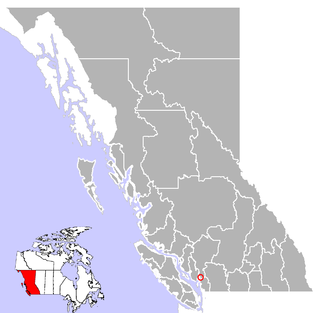
Britannia Beach is a small unincorporated community in the Squamish-Lillooet Regional District located approximately 55 kilometres north of Vancouver, British Columbia on the Sea-to-Sky Highway on Howe Sound. It has a population of about 300. It includes the nearby Britannia Creek, a small to mid-sized stream that flows into Howe Sound that was historically one of North America's most polluted waterways.

Anyox was a small company-owned mining town in British Columbia, Canada. Today it is a ghost town, abandoned and largely destroyed. It is located on the shores of Granby Bay in coastal Observatory Inlet, about 60 kilometres southeast of Stewart, British Columbia, and about 20 kilometres, across wilderness, east of the tip of the Alaska Panhandle.

Thutade Lake is located in the Omineca Mountains of the Northern Interior of British Columbia, Canada. About 40 km (25 mi) in length, and no more than about 2 km (1.2 mi) wide, the lake is primarily significant as the ultimate source of the Mackenzie River. The lake is at the head of the Finlay River, which joins the Peace River via Williston Lake. The area is very remote, being located about 260 km (160 mi) north of Smithers, although several mining operations for ores containing copper, lead, zinc and silver have occurred around the lake. The largest of these is the Kemess Mine, an iron and copper property originally owned by Royal Oak Mines and now by Northgate Minerals, located in the valley of Kemess Creek, which is off the northeast end of Thutade Lake. The mine is accessed by the Omineca Resource Road and other resource routes, and is 400 km (250 mi) by road from Prince George. Just downstream from the outlet of Thutade Lake, the Finlay plunges over the 180-foot (55 m) Cascadero Falls, and then through a series of cataracts in a twisting course until it begins its main northeastward trend. Cascadero Falls is slated for hydroelectric development in connection with the power needs of the area's mines.

Minto City, often called just Minto, sometimes Minto Mines,Minto Mine, Skumakum, or "land of plenty", was a gold mining town in the Bridge River Valley of British Columbia from 1930 to 1936, located at the confluence of that river with Gun Creek, one of its larger tributaries. The mine prospect was never much successful although a model townsite was built by promoter "Big Bill" Davidson, who imported soil to build a specially-built rodeo ground and baseball diamond on the rocky site. The larger mine of Bralorne was nearby. The mine shut down in 1936 due to productivity issues, but restarted in 1940. The valley has since been significantly altered when most of the vestiges of the town were inundated by the waters of the Carpenter Lake reservoir following completion of the Bridge River Power Project. In 1941, around two dozens of Japanese Canadian families were relocated to Minto Mine, and ordered to live in the empty miners' houses due to the impacts of the war.

Black Dome Mountain is the northernmost summit of the Camelsfoot Range, which lies along the west side of the Fraser River, north of Lillooet, British Columbia, Canada. It is an ancient butte-like volcano located in the formation known as the Chilcotin Group, which lie between the Pacific Ranges of the Coast Mountains and the mid-Fraser River in British Columbia, Canada.

<span class="mw-page-title-main">Kemess Mine</span>

The Kemess Mine was an open-pit copper and gold mine, located just northeast of the foot of Thutade Lake, at the head of the Finlay River, in the Omineca Mountains of the Northern Interior of British Columbia, Canada. It was operated by Royal Oak Mines from 1998 to 1999, when it was bought by Northgate Minerals. Northgate operated the mine until its closure in 2011; that year Northgate was taken over by AuRico Gold. In 2014 AuRico Gold partitioned off its portion of Kemess Mine ownership creating a new company called AuRico Metals.

<span class="mw-page-title-main">Bralorne</span>

Bralorne is a historic Canadian gold mining community in the Bridge River District of British Columbia, some 130 km on dirt roads west of the town of Lillooet.

Tasu or Tassoo, also Old Tasu or Old Tasu Townsite, was an iron and copper open pit and underground mining operation and townsite located on the south shore of Tasu Sound in west-central Moresby Island in the Queen Charlotte Islands of the North Coast of British Columbia, Canada. It ran from 1918 until the early 1980s, with the townsite growing full size in the early 1960s. The early iron mine was owned and worked by Japanese miners, with the mine finishing operation as Wesfrob Mine, owned by Falconbridge Nickel Mines.

Allenby was an important copper-mining company town in the Similkameen Country of the Southern Interior of British Columbia, Canada, just south of the town of Princeton. It was for a short time the location of the Copper Mountain post office but that name was reinstated to its original site when the neighbouring Copper Mountain mining town, affiliated with the same mine, was revived.

McGillivray, formerly McGillivray Falls, is an unincorporated recreational community on the west shore of Anderson Lake, just east of midway between the towns of Pemberton and Lillooet, British Columbia, Canada, in that province's southwest Interior.

<span class="mw-page-title-main">Cayoosh Creek</span> River in Canada

Cayoosh Creek is a northeast-flowing tributary of the Seton River in the Canadian province of British Columbia. The name Cayoosh Creek remains on the bridge-sign crossing the stream on BC Highway 99 and continues in use locally to refer to the final reaches of the Seton River, formerly Seton Creek, which prior to the renaming ending at the confluence with Cayoosh Creek. The creek is the namesake of Cayoosh Creek Indian Reserve No. 1, one of the main Indian reserves of the Cayoose Creek Indian Band, which lies adjacent to what was renamed the Seton River without local consultation.

Premier was a large gold mining camp in British Columbia, Canada, some 18 miles from Stewart. It ran from the years 1918 to 1953 and was a large employer in the area. Huge bunkhouses, generators, concentrators, machine and cookhouses sat on the hillside. A road provided access to the area, snowfall pending. Horses and cart tractors were used.

Granby Consolidated Mining, Smelting and Power Co. was established by charter to operate in the Boundary region of southern British Columbia. Primarily involved in the mining and smelting of copper, the conglomerate became a publicly traded company. The various corporate operating names within the former group mostly specified the Granby identity.

Vital Creek is a creek located in the Omineca Country region of British Columbia, flowing eastward from its source in the Vital Range to meet Silver Creek, joining that creek from the west about 5 miles from its mouth into the Omineca River, about 41 km northeast of Takla Landing.

Brexton, formerly known as Fish Lake, is a ghost town located in the Bridge River Country region of British Columbia. Although the provincial Gazetteer still lists the "settlement" of Brexton, which was situated between the southeast end of Gun Lake and Gold Bridge, and three and a half miles north of Bralorne, this once busy town has mostly vanished though a few buildings remain. The old town site now sits mainly on private property.

<span class="mw-page-title-main">Granduc Mine</span>

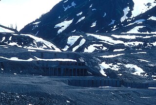
Overlooking the Salmon Glacier, the Granduc Mine is a large copper mine which is situated on a rock ridge between a glacier and a cliff, some 22 miles (35 km) north of Stewart, BC at the north end of Summit Lake. It was an active mine from 1964 to 1984, having closed due to low copper prices.

<span class="mw-page-title-main">Highland Valley Copper mine</span>

The Highland Valley Copper mine is the largest open-pit copper mine in Canada, located near Logan Lake, British Columbia. It is an amalgamation of three historic mining operations: Bethlehem, Lornex and Highmont.

The New Afton mine is a Canadian gold and copper mine located 17 kilometres (11 mi) west of the city of Kamloops in British Columbia. The mine is underground and is owned and operated by New Gold Inc. In 2019, the mine produced an output of 79,000,000 pounds (36,000,000 kg) of copper, and 69,000 ounces of gold. The Afton Group covers 61 claims on 12,450 hectares (124.5 km2) of property.

The Gibraltar Mine is a Canadian copper mine operated by Taseko Mines near McLeese Lake in British Columbia, Canada. It is the second largest open-pit mine in Canada and the fourth largest in North America.

References

  1. By order of importance in showing/production. Commodities shown in brackets are from showings and prospects associated with the producing mine, but are not under production
  2. In the case of sequential or multiple owners, only the last owner, or the largest shareholder, will be named, or the company best known for association with the mine, either by stature or longevity. For more details see the references in each case. Founders/discoverers or notable individual promoters/investors may be named in the "Comments" column.
  3. MINFILE Mineral Inventory, Blue Hawk Mine
  4. MINFILE Mineral Inventory
  5. MINFILE Mineral Inventory, Bralorne Mine
  6. MINFILE Mineral Inventory, Britannia Mine
  7. BCGNIS|49996|Bullion (mining camp) [ permanent dead link ]
  8. BC Govt Property File search
  9. MINFILE Mineral Inventory
  10. Infomine listing
  11. MINFILE Mineral Inventory, Cariboo-Amelia Mine
  12. Infomine.com listing "Camp McKinney
  13. MINFILE Mineral Inventory, McKinney Creek Placer
  14. MINFILE Mineral Inventory
  15. MINFILE Mineral Inventory
  16. MINFILE Mineral Inventory
  17. MINFILE Mineral Inventory, Copper Mountain Mine
  18. MINFILE Mineral Inventory, Ingerbelle Mine
  19. "Craigmont Mines". Archived from the original on 2009-04-05. Retrieved 2009-08-28.
  20. BC MINFILE Mineral Inventory
  21. MINFILE Mineral Inventory, Estella Mine
  22. MINFILE Mineral Inventory, Giant Mascot
  23. MINFILE Mineral Inventory, Star of Emeory 3 (Giant Mascot)
  24. MINFILE Mineral Inventory, Pride of Emory (Giant Mascot)
  25. MINFILE Mineral Inventory, Golden Cache
  26. Short Portage to Lillooet, Irene Edwards, self-publ., Lillooet, 1976
  27. Halfway to the Goldfields: A History of Lillooet, Lorraine Harris, Sunfire Publications
  28. The Great Years: Gold Mining in the Bridge River Valley, Lewis Green, Tricouni Books, 2000
  29. MINFILE Mineral Inventory, Granisle
  30. MINFILE Mineral Inventory, Hat Creek Coal, Hat Creek No. 1, Hat Creek No. 2
  31. MINFILE Mineral Inventory, Pacific Bentonite/Hat Creek
  32. MINFILE Mineral Inventory, Hidden Creek Mine/Anyox Mine
  33. Various: see MINFILE Search "Highland Valley"
  34. Pratt, Morton E. (1990). "Island Copper Mine". In Kennedy, Bruce A. (ed.). Surface Mining (2 ed.). Littleton, Colorado: Society for Mining, Metallurgy, and Exploration. pp. 1163–1175. ISBN   9780873351027 . Retrieved 6 August 2019.
  35. Wilton, Mike J.; Lawrence, Gregory A. (1998). "The Evolution of the Island Copper Mine Pit Lake" (PDF). Proceedings of the 22nd Annual British Columbia Mine Reclamation Symposium. Penticton, BC: The Technical and Research Committee on Reclamation. Retrieved 6 August 2019.
  36. MINFILE Mineral Inventory, Kemess South
  37. MINFILE Search, "Kemess"
  38. MINFILE Mineral Inventory, Kitsault Mine
  39. MINFILE Mineral Inventory, Minto Mine
  40. Morton, Brian (1 October 2012). "Morrison Lake mine rejected by B.C. government over concerns about salmon". The Vancouver Sun . Retrieved 3 October 2012.
  41. "Morrison Mine project denied Environmental Assessment Certificate". British Columbia Information Bulletin 2012ENV0061-001446. 1 October 2012. Archived from the original on 6 October 2012. Retrieved 3 October 2012.
  42. MINFILE Mineral Inventory
  43. MINFILE Mineral Inventory, Phoenix (Knob Hill)
  44. MINFILE Search "Phoenix"
  45. MINFILE Mineral Inventory
  46. MINFILE Mineral Inventory, Premier Mine/Premier Silbak
  47. MINFILE Mineral Inventory, Northern Lights/Premier Border
  48. Vancouver Mine/Premier Extension
  49. MINFILE Mineral Inventory, Quinsam Coal
  50. MINFILE Mineral Inventory, Quintette
  51. MINFILE Mineral Inventory, Quintette Shikano)
  52. MINFILE Mineral Inventory, Babcock (Quintette)
  53. MINFILE Mineral Inventory, Quintette (Frame)
  54. "World gold deposits" (PDF). nrh.co.il. 2012. Archived from the original (PDF) on April 29, 2013. Retrieved 2013-07-18.
  55. MINFILE Mineral Inventory
  56. MINFILE Mineral Inventory
  57. MINFILE Mineral Inventory
  58. MINFILE Mineral Inventory, Tulsequah Chief Mine
  59. MINFILE Mineral Inventory, Big Bull/Tulsequah Chief