Dumfries and Galloway is one of 32 unitary council areas of Scotland and is located in the western Southern Uplands. It covers the historic counties of Dumfriesshire, Kirkcudbrightshire, and Wigtownshire, the latter two of which are collectively known as Galloway. The administrative centre and largest settlement is the town of Dumfries. The second largest town is Stranraer, on the North Channel coast, some 76 miles (122 km) to the west of Dumfries.
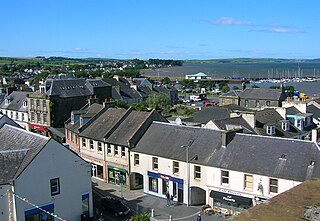
Stranraer, also known as The Toon, is a town in Dumfries and Galloway, Scotland. It is located in the historical parish of Inch in the historic county of Wigtownshire. It lies on the shores of Loch Ryan, on the northern side of the isthmus joining the Rhins of Galloway to the mainland. Stranraer is Dumfries and Galloway's second-largest town, with a population including the immediate surrounding area of nearly 13,000 inhabitants.

Kirkcudbrightshire, or the County of Kirkcudbright or the Stewartry of Kirkcudbright is one of the historic counties of Scotland, covering an area in the south-west of the country. Until 1975, Kirkcudbrightshire was an administrative county used for local government. Since 1975, the area has formed part of Dumfries and Galloway for local government purposes. Kirkcudbrightshire continues to be used as a registration county for land registration. A lower-tier district called Stewartry covered the majority of the historic county from 1975 to 1996. The area of Stewartry district is still used as a lieutenancy area. Dumfries and Galloway Council also has a Stewartry area committee.

Dumfriesshire or the County of Dumfries or Shire of Dumfries is a historic county and registration county in southern Scotland. The Dumfries lieutenancy area covers a similar area to the historic county.

The Rhins of Galloway, otherwise known as the Rhins of Wigtownshire, is a hammer-head peninsula in Dumfries and Galloway, Scotland. Stretching more than 25 miles from north to south, its southern tip is the Mull of Galloway, the southernmost point of Scotland.

Wanlockhead is a village in Dumfries and Galloway, Scotland, nestling in the Lowther Hills and 1 mile south of Leadhills at the head of the Mennock Pass, which forms part of the Southern Uplands. It is Scotland's highest village, the village centre being at an elevation of around 405 m (1,329 ft) above sea level. Some sources, including VisitScotland, cite an altitude of 467 metres (1,532 ft) but the highest house in the village has been measured at 444 metres (1,457 ft).
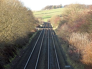
The Portpatrick and Wigtownshire Joint Railways was a network of railway lines serving sparsely populated areas of south-west Scotland. The title appeared in 1885 when the previously independent Portpatrick Railway (PPR) and Wigtownshire Railway (WR) companies were amalgamated by Act of Parliament into a new company jointly owned by the Caledonian Railway, Glasgow & South Western Railway, Midland Railway and the London & North Western Railway and managed by a committee called the Portpatrick and Wigtownshire Joint Committee.
The Glasgow, Dumfries and Carlisle Railway was a railway company in Scotland, which constructed the line from near Cumnock to Gretna Junction, forming the route from Glasgow to Carlisle via Dumfries, in association with other lines. Its promoters hoped it would form the only railway between central Scotland and England, but it lost out to rival companies.

The Glasgow South Western Line is a mainline railway in Scotland that runs from Glasgow to Kilmarnock, and then either Carlisle via Dumfries, or Stranraer via Ayr, with a branch to East Kilbride.
Sorbie is a small village in Wigtownshire, Machars, within the Administration area of Dumfries and Galloway Council, Scotland.
The Dumfries & Galloway Standard is a tabloid newspaper which primarily serves Dumfries and the surrounding towns and villages such as Thornhill, Sanquhar, Lockerbie and Annan. But it also covers Castle Douglas, Kirkcudbright, Gretna and news in Wigtownshire such as in the town of Stranraer. Its sister paper is the Galloway News which covers the Galloway area more in depth with Castle Douglas, Kirkcudbright and Dalbeattie the three main towns in its patch. Both are part of Reach plc.

The Lowther Hills, also sometimes known as the Lowthers, are an extensive area of hill country in the Southern Uplands of Scotland, though some sub-ranges of hills in this area also go under their own local names - see "Hillwalking" below. They form a roughly rhomboidal or lozenge shape on the map with the acute angles being to north and south. It has river valleys along its boundaries to north east (Clydesdale) and south west (Nithsdale) which carry the two largest arterial routes northwards into the west side of the Central Belt of Scotland. A string of small towns have long since developed along these routes. Most of the Lowther Hills lie in the Administrative County of Dumfries and Galloway, though part in the administrative county of South Lanarkshire moves into them around the village of Leadhills and the Daer Reservoir.

The Carsphairn and Scaur Hills are the western and eastern hills respectively of a hill range in the Southern Uplands of Scotland. Ordnance Survey maps don't have a general name for the hill area as a whole. Also, Ordnance Survey use "Scar" rather than the local spelling of "Scaur" - the word is pronounced as "Scar" however. In their Landranger Series of maps, it requires four separate sheets to cover the area.
Mennock Lye Goods Depot or Mennock Siding was a railway freight facility located off the A76 in the hamlet of Mennock that lies circa two miles south-east of Sanquhar, Dumfries and Galloway, Scotland. Situated 68 miles (109 km) from Glasgow it served the industrial and agricultural requirements for transportation in the vicinity of Mennock and the surrounding rural area, originally on behalf of the Glasgow, Dumfries and Carlisle Railway. The goods depot was located on a section of line with a falling southbound gradient of 1 in 160. No passenger railway station has been recorded for Mennock.
Mennock is a small village or hamlet which lies 2 miles (3.2 km) south-east of Sanquhar on the A76, in Dumfriesshire, in the District Council Region of Dumfries and Galloway, southwest Scotland. Its original nucleus are the old smithy and corn mill with associated buildings. The site is dominated by the A76 that runs through the centre of Mennock. The village has expanded in recent years with housing on the River Nith side of the A76.

Kirkbride, previously Kilbride was an ancient parish close to the village of Enterkinfoot, the lands of which lay on both sides of the River Nith in the old Strathnith area of Dumfries and Galloway, Scotland, about 5 miles south of Sanquhar and north of Closeburn. The parish was suppressed and divided between Durisdeer and Sanquhar parishes in 1732. The ruins of the kirk are a scheduled monument and the surrounding graveyard is a Category B listed building with the River Nith in the valley below. The Ha Cleuch Burn flows through the glen that lies to the east of the site with a lane reaching it that runs up from Enterkinfoot, ending at Coshogle Farm.