
Cherokee County, Alabama is a county located in the northeastern part of the U.S. state of Alabama. As of the 2010 census, the population was 25,989. Its county seat is Centre. The county is named for the Cherokee tribe.
DeKalb County is a county located in the northeastern part of the U.S. state of Alabama. As of the 2010 census, the population was 71,109. Its county seat is Fort Payne, and it is named after Major General Baron Johan DeKalb. DeKalb County is part of the Huntsville-Decatur-Albertville, AL Combined Statistical Area.

Monroe County is a county on the southeastern border of the U.S. state of Tennessee. As of the 2010 census, the population was 44,519. Its county seat is Madisonville.

Cherokee County is located in the US state of Georgia. As of 2019 estimates, the population was 258,773. The county seat is Canton, population 29,306 (2018). The county Board of Commissioners is the governing body, with members elected to office.

Cherokee is a town in west Colbert County, Alabama, United States. It is part of the Florence–Muscle Shoals metropolitan area, known as "The Shoals". As of the 2010 census, the population of the town was 1,048.

The term "Five Civilized Tribes" derives from the colonial and early federal period in the history of the United States. It refers to five Native American nations—the Cherokee, Chickasaw, Choctaw, Creek (Muscogee), and Seminole. These are the first five tribes that European Americans generally considered to be "civilized". Examples of colonial attributes adopted by these five tribes, which led European Americans to label them civilized, include Christianity, centralized governments, literacy in English, market participation, written constitutions, intermarriage with white Americans, and plantation slavery practices. The Five Civilized Tribes tended to maintain stable political relations with the European Americans.

The Tennessee River is the largest tributary of the Ohio River. It is approximately 652 miles (1,049 km) long and is located in the southeastern United States in the Tennessee Valley. The river was once popularly known as the Cherokee River, among other names, as many of the Cherokee had their territory along its banks, especially in eastern Tennessee and northern Alabama. Its current name is derived from the Cherokee village Tanasi.

The Qualla Boundary or The Qualla is territory held as a land trust by the United States government for the federally recognized Eastern Band of Cherokee Indians, who reside in western North Carolina. The area is part of the Cherokee's historic territory. The tribe purchased the land in the 1870s, and it was subsequently placed under federal protective trust; it is not a reservation created by the government. Individuals can buy, own, and sell the land, provided they are enrolled members of the Tribe of the Eastern Band of the Cherokee Indians.

The Coosa River is a tributary of the Alabama River in the U.S. states of Alabama and Georgia. The river is about 280 miles (450 km) long.
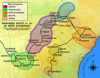
The Coosa chiefdom was a powerful Native American paramount chiefdom in what are now Gordon and Murray counties in Georgia, in the United States. It was inhabited from about 1400 until about 1600, and dominated several smaller chiefdoms. The total population of Coosa's area of influence, reaching into present-day Tennessee and Alabama, has been estimated at 50,000.
Black Fox, also called Enola, was a Cherokee leader during the Cherokee–American wars. He was a signatory of the Holston Treaty, and later became a Principal Chief of the Cherokee Nation.

Citico is a prehistoric and historic Native American site in Monroe County, Tennessee, in the southeastern United States. The site's namesake Cherokee village was the largest of the Overhill towns, housing an estimated population of 1,000 by the mid-18th century. The Mississippian village that preceded the site's Cherokee occupation is believed to have been the village of "Satapo" visited by the Juan Pardo expedition in 1567.
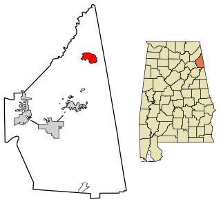
Broomtown is an unincorporated community and census-designated place in Cherokee County, Alabama, United States. As of the 2010 census, its population was 182. It was named after Chief Broom (Broomstown) of the Cherokee Nation, who occupied the area from the late eighteenth century into the 1830s. The Cherokee migrated southwest under pressure from European-American encroachment, before being driven out of the Southeast on the Trail of Tears to Indian Territory west of the Mississippi River.

Long Island is an unincorporated community in the northeastern corner of Jackson County, Alabama, United States. Long Island appears on the Bridgeport U.S. Geological Survey Map. It was reportedly named Carpenter for a family that lived there prior to 1852, when it was given the English form of the original Cherokee name of the village on the long island in the Tennessee River dating from 1783.

New Town(Cherokee: ᎤᏍᏔᎾᎵ, romanized: Ustanali) is an unincorporated community in Gordon County, Georgia, United States, located northeast of Calhoun. New Town is near the New Echota historic site, which was formerly part of the Cherokee Nation. Ashworth Middle School and Gordon Central High School are located in the New Town community.
The Treaty of Turkeytown, also known as the Treaty with the Cherokee and the Treaty of Chickasaw Council House was negotiated on 14 September 1816, between delegates of the former Cherokee Nation on the one part and Major General Andrew Jackson, General David Meriwether and Jesse Franklin, Esq., who served as agents of the United States in the capacity of "commissioners plenipotentiary", on the other part. Conducted following the Creek War, the initial meeting was held at the Chickasaw Council House and stipulated a further meeting on 28 September 1816, to be conducted at "Turkey's Town", on the Coosa River, near the present day town of Centre, in Cherokee County, Alabama. The treaty was ratified by the Cherokee Nation at Turkeytown on 4 October 1816, and signed by Pathkiller, then Principal Chief of the Cherokee Nation.

The Native American settlement of Turkeytown, sometimes called "Turkey's Town", was named after the original founder of the settlement, the Chickamauga Cherokee chief, Little Turkey. At one point in history, this seemingly inconspicuous village stretched for approximately 25 miles along both banks of the Coosa River, and became the largest of the contemporary Cherokee towns.
Cherokee Bluffs is an unincorporated community in Tallapoosa County, Alabama, United States. The bluffs were a landmark in Tallapoosa County, and they were chosen as the first site on the Tallapoosa River for the creation of a dam and reservoir.
Ellisville, also known as Coloma, is an unincorporated community in Cherokee County, Alabama, United States.
Turkey Town is a ghost town in Cherokee County, in the U.S. state of Alabama.


