A medicine man or medicine woman is a traditional healer and spiritual leader who serves a community of indigenous people of the Americas. Individual cultures have their own names, in their respective Indigenous languages, for the spiritual healers and ceremonial leaders in their particular cultures.

Cherokee County, Alabama is a county located in the northeastern part of the U.S. state of Alabama. As of the 2010 census, the population was 25,989. Its county seat is Centre. The county is named for the Cherokee tribe.

DeKalb County is a county located in the northeastern part of the U.S. state of Alabama. As of the 2010 census, the population was 71,109. Its county seat is Fort Payne, and it is named after Major General Baron Johan DeKalb. DeKalb County is part of the Huntsville-Decatur-Albertville, AL Combined Statistical Area.

Monroe County is a county on the southeastern border of the U.S. state of Tennessee. As of the 2010 census, the population was 44,519. Its county seat is Madisonville.

Oconee County is the westernmost county in the U.S. state of South Carolina. As of the 2010 census, the population was 74,273. Its county seat is Walhalla.

Cherokee County is located in the US state of Georgia. As of 2019 estimates, the population was 258,773. The county seat is Canton, population 29,306 (2018). The county Board of Commissioners is the governing body, with members elected to office.

Tahlequah is a city in Cherokee County, Oklahoma, United States located at the foothills of the Ozark Mountains. It is part of the Green Country region of Oklahoma and was established as a capital of the 19th-century Cherokee Nation in 1839, as part of the new settlement in Indian Territory after the Cherokee Native Americans were forced west from the American Southeast on the Trail of Tears.
Tryon County is a former county which was located in the U.S. state of North Carolina. It was formed in 1768 from the part of Mecklenburg County west of the Catawba River, although the legislative act that created it did not become effective until April 10, 1769. Due to inaccurate and delayed surveying, Tryon County encompassed a large area of northwestern South Carolina. It was named for William Tryon, governor of the North Carolina Colony from 1765 to 1771.

The Cherokee National Forest is a United States National Forest located in the U.S. states of Tennessee and North Carolina that was created on June 14, 1920. The forest is maintained and managed by the United States Forest Service. It encompasses an estimated area of 655,598 acres (2,653.11 km2).

The Lumbee Tribe of North Carolina is a state-recognized tribe in North Carolina numbering approximately 55,000 enrolled members, most of them living primarily in Robeson, Hoke, Cumberland and Scotland counties. The Lumbee Tribe is the largest state tribe in North Carolina, the largest state tribe east of the Mississippi River, and the ninth largest non-federally recognized tribe in the United States. The Lumbee take their name from the Lumber River which winds through Robeson County. Pembroke, North Carolina, is the economic, cultural and political center of the tribe. The Lumbee Tribe was recognized as a Native American tribe by the United States Congress in 1956, under conditions that it agreed to at the time, which did not allow them to have benefits available to other federally recognized tribes. According to the 2000 United States Census report, 89% of the population of the town of Pembroke, North Carolina, identify as Lumbee; 40% of Robeson County's population identify as Lumbee.
McCord is the placename for several places in the Canada and the United States:

Johns Creek is a city in Fulton County, Georgia, United States. According to the 2010 U.S. Census, the population was 76,728. The city is a northeastern suburb of Atlanta. In 2017, Johns Creek ranked third on the USA TODAY list of "50 best cities to live in."
Andrew McCord was a United States Representative from New York. The name is often spelled MacCord, especially in newspapers of the time.

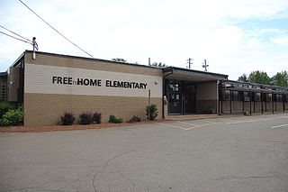
Free Home is an unincorporated community in the eastern part of Cherokee County, Georgia, United States. Centered at the intersection of state highways 20 and 372, the rural community has seen moderate suburbanization of the area since the late 1990s. It is home to Free Home Elementary School. The community is home to a Publix Supermarket center, which has a few stores/restaurants. There is also a Tractor Supply Company that was completed in September 2011.

Cashion Crossroads is a small unincorporated community located in the northern part of Cherokee County, South Carolina, United States. The community is named for the Cashion family, who mainly settled in the area at first. The community used to have a two-room school house, which no longer stands. Today, there is a small convenience store located at the crossroads. Also, west of the community is Hopewell Baptist Church.

Adams Crossroads is an unincorporated community in Cherokee County, Alabama, United States.

McFrey Crossroads is an unincorporated community in Cherokee County, Alabama, United States.

McGhee is an unincorporated community in Cherokee County, Alabama, United States.

Newberry Crossroads, also known as Bid, is an unincorporated community in Cherokee County, Alabama, United States.


