
Cherokee County, Alabama is a county located in the northeastern part of the U.S. state of Alabama. As of the 2010 census, the population was 25,989. Its county seat is Centre. The county is named for the Cherokee tribe.

Smith County is a county in the U.S. state of Texas. As of the 2010 census, its population was 209,714. Its county seat is Tyler. Smith County is named for James Smith, a general during the Texas Revolution.

Grainger County is a county located in the U.S. state of Tennessee. As of the 2010 census, the population was 22,657. Its county seat is Rutledge.

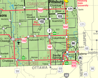
Cherokee County is a U.S. county located in Southeast Kansas. As of the 2010 census, the county population was 21,603. Its county seat is Columbus, and its most populous city is Baxter Springs. The latter became the first "cow town" in Kansas during the 1870s and the period of cattle drives.

Murray County is a county located in the northwestern part of the U.S. state of Georgia. As of the 2010 census, the population was 39,628. The county seat is Chatsworth.

Gordon County is a county located in the northwestern part of the U.S. state of Georgia. As of the 2010 census, the population was 55,186. The county seat is Calhoun. Gordon County comprises the Calhoun, GA Micropolitan Statistical Area, which is included in the Atlanta-Athens-Clarke County-Sandy Springs, GA Combined Statistical Area.

Cherokee County is located in the US state of Georgia. As of 2019 estimates, the population was 258,773. The county seat is Canton, population 29,306 (2018). The county Board of Commissioners is the governing body, with members elected to office.

Sanford is a city in the central region of the U.S. state of Florida and the county seat of Seminole County. As of the 2010 census, its population was 53,570.

Canton is a city in and the county seat of Cherokee County, Georgia, United States. As of the 2010 census, the city had a population of 22,958, up from 7,709 in 2000.
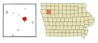
Cherokee is a city in Cherokee County, Iowa, United States. The population was 5,253 at the 2010 Census, down from 5,369 in 2000. It is the county seat of Cherokee County.

The Qualla Boundary or The Qualla is territory held as a land trust for the federally recognized Eastern Band of Cherokee Indians, who reside in western North Carolina. The area is part of the Cherokees' historic territory. The land was not "reserved" by the federal government; the tribe purchased the land in the 1870s and it was subsequently placed under federal protective trust. Individuals can buy, own, and sell the land, provided they are enrolled members of the Tribe of the Eastern Band of the Cherokee Indians.

Cherokee is an unincorporated community and census-designated place in Butte County, California. It is an area inhabited by Maidu Indians prior to the gold rush, but that takes its name from a band of Cherokee prospectors who perfected a mining claim on the site. The population was 69 at the 2010 census. It lies at an elevation of 1306 feet.
Black Fox, also called Enola, was a Cherokee leader during the Cherokee–American wars. He was a signatory of the Holston Treaty, and later became a Principal Chief of the Cherokee Nation.

Sixes, home to approximately 14,540, is an unincorporated community in western Cherokee County, Georgia, United States, located about three miles west of Holly Springs and near the eastern shore of current-day Lake Allatoona. The community is located in the Georgia Gold Belt, which runs southwest to northeast along the southern edge of the Blue Ridge mountains. The Sixes Gold Mine, a now-defunct gold mine dating back to the early 19th century, was located just to the northwest. In addition, the community is home to the Sixes Mill, which was originally built around 1820 by early gold prospectors and later rebuilt circa 1880. The mill has been well preserved and is still located off Sixes Road. There are two theories on how Sixes derived its name. The first theory attributes the name to Fort Hinar Sixes, a Cherokee Indian removal fort that was located in the area along the Trail of Tears. The second holds that the name is derived from an old Cherokee village that was located near the Etowah River named "Sutali" — the Cherokee word for the number six. Sixes also lent its name to Fort Sixes, an 1830s US Army fort that served as a removal collection point for Cherokee prior to the Trail of Tears. Sutallee, a community that sits on the opposite side of the Etowah River in western Cherokee County, also derives its name from this Native American village. Today, Sixes is a growing suburban community with many large, upscale residential neighborhoods, including BridgeMill. The area is served by two elementary schools ; one middle school (Freedom); and two high schools.
Plumwood is a census-designated place in central Monroe Township, Madison County, Ohio, United States. It lies at the intersection of State Route 38 with Arthur Bradley Road, 8½ miles north of the city of London, the county seat of Madison County. The Spring Fork of the Little Darby Creek flows past the community.

Spring Garden is a census-designated place and unincorporated community in Cherokee County, Alabama, United States. Its population was 238 as of the 2010 census. The area was also known as Amberson or Ambersonville in the 19th century. It was erroneously called "Aubersonville" in the 1880 U.S. Census.

The Hair Conrad Cabin is a historic log cabin in Bradley County, Tennessee, United States, and the oldest residential structure in the county.
Lowell is an unincorporated community in Cherokee County, Kansas, United States. As of the 2010 census, the CDP population was 283.

Teresita is an unincorporated community and census-designated place (CDP) in Cherokee County, Oklahoma, United States. The population was 159 at the 2010 census.

