The Isle of Man is an island in the Irish Sea, between Great Britain and Ireland in Northern Europe, with a population of almost 85,000. It is a British Crown dependency. It has a small islet, the Calf of Man, to its south. It is located at 54°15′N4°30′W.
Glen Wyllin is a glen in the Isle of Man. It is one of the officially-listed Manx National Glens.
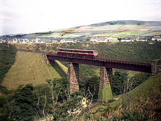
Cornaa Halt is an intermediate stopping place on the northern section of the Manx Electric Railway on the Isle of Man.
Glen Mona Railway Station is an intermediate stopping place on the northerly section of the Manx Electric Railway on the Isle of Man.
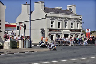
Parliament Square, Ramsey is situated between the 23rd and 24th Milestone road-side markers on the Snaefell Mountain Course used for the Isle of Man TT Races on the junction of the primary A3 Castletown to Ramsey road, the A9 Ramsey to Andreas road and A2 Douglas to Ramsey road situated in the town of Ramsey in the parish of Lezayre in the Isle of Man.

Ramsey Hairpin is a point on the Snaefell Mountain Course used for the Isle of Man TT races on the Snaefell Mountain Road, designated as A18, in the parish of Maughold in the Isle of Man.

The Silver Burn or Silverburn River is a small river, about five miles (8 km) long, on the Isle of Man which rises near the South Barrule and flows south. It passes St Mark's and in its lower reaches it flows under the Monks' Bridge at Ballasalla, and reaches the sea at Castletown harbour. Just above Ballasalla, the burn runs through wooded Silverdale Glen, a site which the Manx National Trust acquired in 1966.

Ballig is a small hamlet of a few houses situated between the 8th and 9th Milestone road-side markers on the Snaefell Mountain Course between Ballacraine and Glen Helen. It is the site of a former notorious hump-back bridge used for the Isle of Man TT Races on the primary A3 Castletown to Ramsey and the road junction with the A20 Poortown Road in the parish of German in the Isle of Man.

The Bungalow, Isle of Man, one of a handful of better-known vantage points spread around the Snaefell Mountain Course, is situated adjacent to the 31st Milestone roadside marker on the road junction of the primary A18 Mountain Road, the A14 Sulby Glen Road and the road-tramway crossing for the Snaefell Mountain Railway in the parish of Lezayre in the Isle of Man.

Garwick Glen Halt is a rural intermediate request stop on the east coast route of the Manx Electric Railway on the Isle of Man.

Groudle Glen Station is the first mandatory stopping point and major station on the Manx Electric Railway which serves the village of Groudle Glen in the Isle of Man, and is situated between Groudle Lane and Eskadale on the route to Laxey and Ramsey.

Dhoon Glen Halt is an intermediate stopping place on the northern section of the Manx Electric Railway in the Isle of Man. It is not to be confused with Dhoon Halt, which is the next halt, about 600 metres to the north.

Ballaglass Glen Halt is an intermediate stopping place on the northerly section of the Manx Electric Railway on the Isle of Man.

Devil's Elbow is a hairpin bend situated on the primary A4 Peel to Kirk Michael coast road in the Isle of Man parish of German.

Groudle Lane Halt is a request stop on the Manx Electric Railway on the Isle of Man, located below the line's first summit on the descent into the nearby valley of the same name.

Eskadale Halt is an intermediate request stop on the east coast route of the Manx Electric Railway on the Isle of Man.
Ballagawne Halt is a rural request stop on the Manx Electric Railway on the Isle of Man.

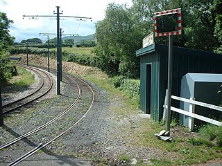
Dolland Halt is a diminutive intermediate stopping place on the northern section of the Manx Electric Railway in the Isle of Man. Although unofficial it remains in use upon request.
Ballacannell Halt is a stop on the Manx Electric Railway on the Isle of Man. This tram station is parallel to Ramsey Road on the A2 road between the villages of Ballaragh and Glen Mona. This station is near Dhoon Glen.

St Adamnan's Church is the former parish church of Lonan in the Isle of Man. The church is situated in an isolated position, surrounded by open farmland on the eastern coast of the island, between Groudle Glen and Baldrine. The eastern part of the church has been restored, but it is otherwise in a ruinous, though well-tended, condition. Adomnán was the Abbot of Iona Abbey between 679 and 704.