
Chitina is a census-designated place (CDP) in Copper River Census Area, Alaska, United States. At the 2010 census the population was 126, up from 123 in 2000.

McCarthy is a census-designated place (CDP) in Copper River Census Area, Alaska, United States. It is in Wrangell-St. Elias National Park and Preserve. The population was 107 at the 2020 census, up from 28 in 2010.

Wrangell–St. Elias National Park and Preserve is an American national park and preserve managed by the National Park Service in south central Alaska. The park and preserve were established in 1980 by the Alaska National Interest Lands Conservation Act. The protected areas are included in an International Biosphere Reserve and are part of the Kluane/Wrangell–St. Elias/Glacier Bay/Tatshenshini-Alsek UNESCO World Heritage Site. The park and preserve form the largest area managed by the National Park Service with a total of 13,175,799.07 acres, an expanse larger than nine U.S. states and around the same size as Bosnia and Herzegovina or Croatia. 8,323,147.59 acres are designated as the national park, and the remaining 4,852,652.14 acres are designated as the preserve. The area designated as the national park alone is larger than the 47 smallest American national parks combined and is more than twice the size of all but two other national parks. Its area makes up over 15% of all national park designated land in the United States.

Kennecott, also known as Kennicott and Kennecott Mines, is an abandoned mining camp in the Copper River Census Area in the U.S. state of Alaska that was the center of activity for several copper mines. It is located beside the Kennicott Glacier, northeast of Valdez, inside Wrangell-St. Elias National Park and Preserve. The camp and mines are now a National Historic Landmark District administered by the National Park Service.

The Copper River and Northwestern Railway (CR&NW) consisted of two rail lines, the Copper River line and the Northwestern line. Michael James Heney had secured the right-of-way up the Copper River in 1904. He started building the railway from Cordova, Alaska in 1906. The town of Cordova, Alaska, was actually named by Heney on March 13, 1906, based on the original name given by Salvador Fidalgo. Both these railroads were abandoned and little remains of them. A 0-4-0 locomotive, "Ole", located near Goose City on a siding of the Alaska Anthracite Railroad Company is the only equipment left. Many of the holdings of the CR&NW railroad including Ole were acquired for this railroad by Mr. Clark Davis and his partners in 1908 after a major storm destroyed the Katalla area facilities in 1907. The town of Cordova would like to move Ole to a memorial site in Cordova to celebrate its role in these railroads. Ole was declared eligible for the National Register of Historic Places in 1988.

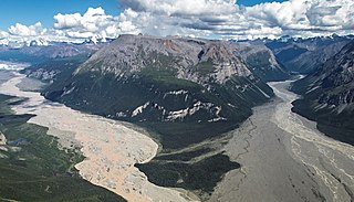
Kennicott Glacier is a glacier in the U.S. state of Alaska. It trends southeast 43 km (27 mi) from Mount Blackburn to its terminus at the head of the Kennicott River in the Wrangell Mountains. It is located in Wrangell-St. Elias National Park near the small town of McCarthy, Alaska and the historic ghost town of Kennecott, Alaska.

The McCarthy Road is a gravel-surfaced road that runs from the end of the Edgerton Highway in Chitina, Alaska, to about 1 mile (1.6 km) outside of McCarthy, Alaska.
Nabesna is a census-designated place and unincorporated community in northern Copper River Census Area, Alaska, United States, in the northern part of the Wrangell-St. Elias National Park and Preserve. It lies along the Nabesna Road, a gravel road that connects it to the Tok Cut-Off at Slana. Its elevation is 2,979 feet (908 m). Founded by and named for the Nabesna Mining Company, the community received a post office in 1909. Located at the base of White Mountain in the Wrangell Mountains, it lies west of the Nabesna River. According to the 2020 census, there were two people residing at this location.

The Bremner Historic Mining District is a historic district in Wrangell-St. Elias National Park and Preserve in Alaska. It is named after John Bremner, who in 1884-1885 was the first non-native person to live in the area and who prospected for gold along the Bremner River. Located just to the north of the Bremner River, it was the scene of an important placer gold discovery in 1902, and played a key role in the history of the Copper River Basin. Only a few miners struck it rich, but the resulting demand for materials and supplies helped establish regional transportation networks, encouraged supporting industries, and hastened the exploration and settlement of the entire region. While small-scale placer mining continued for over forty years, lode development was largely confined to the period between 1934 and 1941, the district's most significant era.

The Alaska–St. Elias Range tundra is an ecoregion of northwestern North America.
This is a list of the National Register of Historic Places listings in Wrangell–St. Elias National Park and Preserve.
The Valdez-Trail is an historic early trail in southern Alaska. It is a section of unpaved roadway, eight to ten feet in width, that extends roughly northward from milepost 106.5 of the Richardson Highway, between Copper Center and Glennallen. It is a rare surviving segment of the original Valdez Trail, the first major road built in Alaska, which extends 700 miles (1,100 km) from Valdez into the Alaskan interior. This segment was constructed in 1900 by the Alaska Road Commission, and is now within Wrangell–St. Elias National Park and Preserve. It was listed on the National Register of Historic Places in 1998.
Kansky's, also known as Kanski's, Big Skookum, is a former boarding house, now used as a hunting lodge, located at mile 42 of the Nabesna Road in Wrangell–St. Elias National Park and Preserve of eastern Alaska. The property includes log cabins, bunkhouses, and storage buildings, which were built in 1934 by Steve Kanski to provide lodging and travel services to road crews and workers at the nearby mines. The two businesses that currently run in Nabesna, Alaska are owned by the Ellis family. Ellis Big Game Guides operates out of the original Kansky Lodge. Devils Mountain Lodge is located adjacent as a Bed&Breakfast and hunting lodge independently. The property, a private in-holding within the bounds of the national park, is now operated as a hunting lodge.
The McCarthy General Store is a historic former general store and boarding house at Kennecott and Skolai Streets in the small community of McCarthy, Alaska, located in the heart of Wrangell-St. Elias National Park and Preserve. At two stories in height and measuring 47 by 56 feet, it is McCarthy's largest building, and one of its oldest. It was built in 1914, during the mining boom at nearby Kennecott. The store occupied the ground floor of the building, and the upper level had eleven rooms for boarders. The building was abandoned after the mining boom ended in the 1930s,.

Donoho Peak is a 6,696-foot-elevation mountain summit located in the Wrangell Mountains, in the U.S. state of Alaska. The peak is situated in Wrangell-St. Elias National Park and Preserve, 6 mi (10 km) north-northwest of Kennecott, and 9 mi (14 km) north of McCarthy, at the confluence of the Kennicott Glacier and Root Glacier. The peak's name was reported in 1931 by the United States Geological Survey. The mountain lies within the Copper River drainage basin. Bears frequent the Donoho Peak and Donoho Lakes area. An ascent of the mountain involves 14 miles round-trip from Kennecott to the summit, including crossing the Root Glacier and gully scramble via the south aspect of the mountain. Ruins of the Regal Mine remain at an elevation of 5,440 feet on the south slope of the mountain. Only small amounts of copper ore were ever produced, however. On a clear day the summit of Donoho Peak offers views of Mount Blackburn to the northwest and the Stairway Icefall on Regal Mountain to the north-northeast.

Fireweed Mountain is a prominent 6,956-foot mountain summit located in the Wrangell Mountains, in the U.S. state of Alaska. The peak is situated in Wrangell-St. Elias National Park and Preserve, immediately west of the terminus of the Kennicott Glacier, and 5 mi (8 km) west-northwest of McCarthy. Precipitation runoff from the eight-mile-long by five-mile-wide mountain drains into tributaries of the Chitina River, which in turn is part of the Copper River drainage basin. The mountain's name was given in the 1920s by Molly Gilmore, a lifelong resident of the McCarthy area, who at age 17, named the mountain for the abundance of fireweed which grew on the mountain following forest fires. Although fireweed is the most common and well-known flower in Alaska, it is not commemorated on any other Alaskan mountain. The mountain's name was officially adopted in 1966 by the U.S. Board on Geographic Names. On a clear day the summit of Fireweed Mountain offers views of Mount Blackburn to the northwest, and Regal Mountain to the northeast.

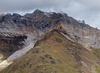
Porphyry Mountain is a prominent 6,375-foot mountain summit located in the Wrangell Mountains, in the U.S. state of Alaska. The peak is situated in Wrangell-St. Elias National Park and Preserve, immediately southeast of Kennecott, 4 mi (6 km) northeast of McCarthy, and, 5 mi (8 km) northwest of Sourdough Peak. Precipitation runoff from the mountain drains into tributaries of the Nizina River, which in turn is part of the Copper River drainage basin. The peak is notable for a rock glacier on its north slope. The mountain was so named because it is largely composed of porphyry, which is a very hard igneous rock. The mountain's local name was reported in 1908 by the U.S. Geological Survey. On a clear day the summit of Porphyry Mountain offers views of Donoho Peak, Kennicott Glacier, and Mount Blackburn to the northwest, and Fireweed Mountain to the west.
Bonanza Peak is a 6,983-foot mountain summit located in the Wrangell Mountains, in the U.S. state of Alaska. The peak was notable for its abundance of copper deposits which were mined from 1909 through 1938. The peak is situated in Wrangell-St. Elias National Park and Preserve, immediately northeast of Kennecott, 7 mi (11 km) northeast of McCarthy, 3.46 mi (6 km) north of Porphyry Mountain, and 5.2 mi (8 km) southeast of Donoho Peak. The confluence of the Kennicott and Root Glaciers lies below the mountain's west slope. Precipitation runoff from the mountain drains into tributaries of the Nizina River, which in turn is part of the Copper River drainage basin. The mountain's local name was reported in 1914 by the U.S. Geological Survey. On a clear day the summit of Bonanza Peak offers views of Sourdough Peak, Mount Blackburn, and Fireweed Mountain.

Williams Peak is a 7,431-foot mountain summit located at the western edge of the Saint Elias Mountains, in the U.S. state of Alaska. The peak is situated in Wrangell-St. Elias National Park and Preserve, 15 mi (24 km) east-southeast of McCarthy, and 4 mi (6 km) west-southwest of Joshua Green Peak in the Dan Creek area. Precipitation runoff from the mountain drains into tributaries of the Nizina River, which in turn is part of the Copper River drainage basin.
Chitistone Mountain is a 6,844-foot (2,086-meter) mountain summit located at the southeastern edge of the Wrangell Mountains, in the U.S. state of Alaska. The peak is situated in Wrangell-St. Elias National Park and Preserve, 15 mi (24 km) east-northeast of McCarthy, 13 mi (21 km) east of Bonanza Peak, and 12 mi (19 km) north of Williams Peak, where it is wedged between the confluence of the Nizina River and Chitistone River.

