Chisana is a census-designated place (CDP) in the Copper River Census Area in the U.S. state of Alaska. As of the 2010 Census, the population of the CDP was 0. The English name Chisana derives from the Ahtna Athabascan name Tsetsaan' Na, meaning literally 'copper river'. The Chisana River joins the Nabesna River just north of Northway Junction, Alaska, to form the Tanana River, a major tributary of the Yukon River. The Chisana Airport consists of a turf and gravel runway which is largely serviced by flights from Tok, Alaska.

Chitina is a census-designated place (CDP) in Copper River Census Area, Alaska, United States. At the 2010 census the population was 126, up from 123 in 2000.

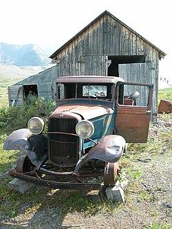
McCarthy is a census-designated place (CDP) in Copper River Census Area, Alaska, United States. It is in Wrangell-St. Elias National Park and Preserve. The population was 107 at the 2020 census, up from 28 in 2010.
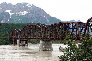
The Miles Glacier Bridge, also known as the Million Dollar Bridge, was built in the early 1900s across the Copper River fifty miles from Cordova in what is now the U.S. state of Alaska. It is a multiple-span Pennsylvania truss bridge which completed a 196-mile (315 km) railroad line for the Copper River and Northwestern Railway, built by J. P. Morgan and the Guggenheim family to haul copper from the old mining town of Kennicott, now located within the Wrangell–St. Elias National Park and Preserve, to the port of Cordova. It earned its nickname because of its $1.4 million cost, well recouped by the about $200 million worth of copper ore which was shipped as a result of its construction.

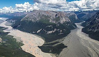
The Copper River or Ahtna River, Ahtna Athabascan ‘Atna’tuu, "river of the Ahtnas", Tlingit Eeḵhéeni, "river of copper", is a 290-mile (470 km) river in south-central Alaska in the United States. It drains a large region of the Wrangell Mountains and Chugach Mountains into the Gulf of Alaska. It is known for its extensive delta ecosystem, as well as for its prolific runs of wild salmon, which are among the most highly prized stocks in the world. The river is the tenth largest in the United States, as ranked by average discharge volume at its mouth.

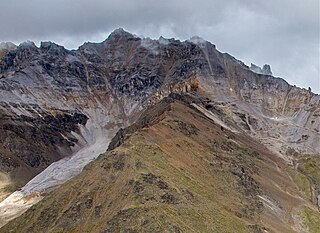
Wrangell–St. Elias National Park and Preserve is a United States national park and preserve in south central Alaska. The park, the largest in the United States, covers the Wrangell Mountains and a large portion of the Saint Elias Mountains, which include most of the highest peaks in the United States and Canada, yet are within 10 miles (16 km) of tidewater, one of the highest reliefs in the world. The park's high point is Mount Saint Elias at 18,008 feet (5,489 m), the second tallest mountain in both the United States and Canada. The park has been shaped by the competing forces of volcanism and glaciation, with its tall mountains uplifted by plate tectonics. Mount Wrangell and Mount Churchill are among major volcanos in these ranges. The park's glacial features include Malaspina Glacier, the largest piedmont glacier in North America, Hubbard Glacier, the longest tidewater glacier in Alaska, and Nabesna Glacier, the world's longest valley glacier. The Bagley Icefield covers much of the park's interior, which includes 60% of the permanently ice-covered terrain in Alaska. At the center of the park and preserve, the boomtown of Kennecott exploited one of the world's richest deposits of copper from 1903 to 1938. The abandoned mine buildings and mills comprise a National Historic Landmark district.

Kennecott, also known as Kennicott and Kennecott Mines, is an abandoned mining camp in the Copper River Census Area in the U.S. state of Alaska that was the center of activity for several copper mines. It is located beside the Kennicott Glacier, northeast of Valdez, inside Wrangell-St. Elias National Park and Preserve. The camp and mines are now a National Historic Landmark District administered by the National Park Service.

The Copper River and Northwestern Railway (CR&NW) consisted of two rail lines, the Copper River line and the Northwestern line. Michael James Heney had secured the right-of-way up the Copper River in 1904. He started building the railway from Cordova, Alaska in 1906. The town of Cordova, Alaska, was actually named by Heney on March 13, 1906, based on the original name given by Salvador Fidalgo. Both these railroads were abandoned and little remains of them. A 0-4-0 locomotive, "Ole", located near Goose City on a siding of the Alaska Anthracite Railroad Company is the only equipment left. Many of the holdings of the CR&NW railroad including Ole were acquired for this railroad by Mr. Clark Davis and his partners in 1908 after a major storm destroyed the Katalla area facilities in 1907. The town of Cordova would like to move Ole to a memorial site in Cordova to celebrate its role in these railroads. Ole was declared eligible for the National Register of Historic Places in 1988.

Kennicott Glacier is a glacier in the U.S. state of Alaska. It trends southeast 43 km (27 mi) from Mount Blackburn to its terminus at the head of the Kennicott River in the Wrangell Mountains. It is located in Wrangell-St. Elias National Park near the small town of McCarthy, Alaska and the historic ghost town of Kennecott, Alaska.

The McCarthy Road is a gravel-surfaced road that runs from the end of the Edgerton Highway in Chitina, Alaska, to about 1 mile (1.6 km) outside of McCarthy, Alaska.

The Bremner River is a 40-mile (64 km) tributary of the Copper River in the Valdez–Cordova Census Area of the U.S. state of Alaska. It was named in 1885 by Lieutenant H. T. Allen for John Bremner, a prospector who sought gold along the river and was the first non-native person to go there.
Nabesna is a census-designated place and unincorporated community in northern Copper River Census Area, Alaska, United States, in the northern part of the Wrangell-St. Elias National Park and Preserve. It lies along the Nabesna Road, a gravel road that connects it to the Tok Cut-Off at Slana. Its elevation is 2,979 feet (908 m). Founded by and named for the Nabesna Mining Company, the community received a post office in 1909. Located at the base of White Mountain in the Wrangell Mountains, it lies west of the Nabesna River. According to the 2020 census, there were two people residing at this location.

The Alaska–St. Elias Range tundra is an ecoregion of northwestern North America.
John Bremner (1833–1887) was a prospector and early explorer of Alaska.
In an effort to thwart statehood and Alaskan home rule from Washington D.C., the Alaska Syndicate, was formed in 1906 by J. P. Morgan and Simon Guggenheim. The Syndicate purchased the Kennicott-Bonanza copper mine and had majority control of the Alaskan steamship and rail transportation. The syndicate also was in charge of a large part of the salmon industry.
The McCarthy General Store is a historic former general store and boarding house at Kennecott and Skolai Streets in the small community of McCarthy, Alaska, located in the heart of Wrangell-St. Elias National Park and Preserve. At two stories in height and measuring 47 by 56 feet, it is McCarthy's largest building, and one of its oldest. It was built in 1914, during the mining boom at nearby Kennecott. The store occupied the ground floor of the building, and the upper level had eleven rooms for boarders. The building was abandoned after the mining boom ended in the 1930s,.
The McCarthy Power Plant, also known as the Mother Lode Coalition Mining Company Power House and the Mother Lode Plant, is a historic power plant building in the small community of McCarthy, Alaska, in the heart of Wrangell-St. Elias National Park and Preserve. It is a three-story wood-frame structure with a clerestory roof, located on the banks of McCarthy Creek. It was built in 1917, after the arrival of the Copper River and Northwestern Railway in the area kicked of a building boom. The coal-fired power plant was built to provide electricity for the operation of a tramway and other facilities of the Kennecott mines. Most of the transmission lines and the tramway were destroyed by avalanches in 1919, and other changes made soon afterward made the power plant unnecessary, and its turbine was moved up to Kennecott.

Donoho Peak is a 6,696-foot-elevation mountain summit located in the Wrangell Mountains, in the U.S. state of Alaska. The peak is situated in Wrangell-St. Elias National Park and Preserve, 6 mi (10 km) north-northwest of Kennecott, and 9 mi (14 km) north of McCarthy, at the confluence of the Kennicott Glacier and Root Glacier. The peak's name was reported in 1931 by the United States Geological Survey. The mountain lies within the Copper River drainage basin. Bears frequent the Donoho Peak and Donoho Lakes area. An ascent of the mountain involves 14 miles round-trip from Kennecott to the summit, including crossing the Root Glacier and gully scramble via the south aspect of the mountain. Ruins of the Regal Mine remain at an elevation of 5,440 feet on the south slope of the mountain. Only small amounts of copper ore were ever produced, however. On a clear day the summit of Donoho Peak offers views of Mount Blackburn to the northwest and the Stairway Icefall on Regal Mountain to the north-northeast.
Bonanza Peak is a 6,983-foot mountain summit located in the Wrangell Mountains, in the U.S. state of Alaska. The peak was notable for its abundance of copper deposits which were mined from 1909 through 1938. The peak is situated in Wrangell-St. Elias National Park and Preserve, immediately northeast of Kennecott, 7 mi (11 km) northeast of McCarthy, 3.46 mi (6 km) north of Porphyry Mountain, and 5.2 mi (8 km) southeast of Donoho Peak. The confluence of the Kennicott and Root Glaciers lies below the mountain's west slope. Precipitation runoff from the mountain drains into tributaries of the Nizina River, which in turn is part of the Copper River drainage basin. The mountain's local name was reported in 1914 by the U.S. Geological Survey. On a clear day the summit of Bonanza Peak offers views of Sourdough Peak, Mount Blackburn, and Fireweed Mountain.
Chitistone Mountain is a 6,844-foot (2,086-meter) mountain summit located at the southeastern edge of the Wrangell Mountains, in the U.S. state of Alaska. The peak is situated in Wrangell-St. Elias National Park and Preserve, 15 mi (24 km) east-northeast of McCarthy, 13 mi (21 km) east of Bonanza Peak, and 12 mi (19 km) north of Williams Peak, where it is wedged between the confluence of the Nizina River and Chitistone River.