
Morgan County is a county in the north central part of the U.S. state of Alabama. As of the 2020 census the population was 123,421. The county seat is Decatur. The county was created by the Alabama Territorial legislature on February 6, 1818, from land acquired from the Cherokee Indians in the Treaty of Turkeytown, and was originally called Cotaco County. On June 14, 1821, it was renamed in honor of American Revolutionary War General Daniel Morgan of Virginia. It is a prohibition or dry county, although alcohol sales are allowed in the cities of Decatur, Hartselle, and Priceville. Morgan County is included in the Decatur, AL Metropolitan Statistical Area, which is also included in the Huntsville-Decatur-Albertville, AL Combined Statistical Area. It is a part of the North, Northwest, and North-Central regions of Alabama.

Lawrence County is a county in the northern part of the U.S. state of Alabama. As of the 2020 census, the population was 33,073. The county seat is Moulton. The county was named after James Lawrence, a captain in the United States Navy from New Jersey.

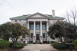
Moulton is a city in Lawrence County, Alabama, and is included in the Decatur Metropolitan Area, as well as the Huntsville-Decatur Combined Statistical Area. Although it incorporated in 1819, along with its rival of Courtland, to compete for the honor of county seat, it did not first appear on the U.S. Census rolls until 1900. As of the 2010 census, the population of the city is 3,471, its record high. The city has been the county seat of Lawrence County since 1820. It has been the largest community in the county since the 1920 U.S. Census.

Decatur is the largest city and county seat of Morgan County in the U.S. state of Alabama. Nicknamed "The River City", it is located in northern Alabama on the banks of Wheeler Lake, along the Tennessee River. The population in 2020 was 57,938.

Hartselle is the second largest city in Morgan County, Alabama, United States, 13 miles (21 km) south of Decatur. It is part of the Decatur Metropolitan Area and the Huntsville-Decatur Combined Statistical Area.
Decatur is a city in, and the county seat of, DeKalb County, Georgia, which is part of the Atlanta metropolitan area. With a population of 24,928 in the 2020 census, the municipality is sometimes assumed to be larger since multiple ZIP Codes in unincorporated DeKalb County bear Decatur as the address. The city is served by three MARTA rail stations. The city is located approximately 5 miles (8.0 km) northeast of Downtown Atlanta and shares its western border with both the city of Atlanta and unincorporated DeKalb County. The Druid Hills neighborhood is to the northwest of Decatur. The unofficial motto of Decatur used by some residents is "Everything is Greater in Decatur."
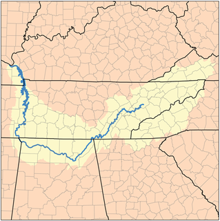
The Tennessee Valley is the drainage basin of the Tennessee River and is largely within the U.S. state of Tennessee. It stretches from southwest Kentucky to north Alabama and from northeast Mississippi to the mountains of Virginia and North Carolina. The border of the valley is known as the Tennessee Valley Divide. The Tennessee Valley contributes greatly to the formation of Tennessee's three legally recognized sectors.

North Alabama is a region of the U.S. state of Alabama. Several geographic definitions for the area exist, with all descriptions including the nine counties of Alabama's Tennessee Valley region. The North Alabama Industrial Development Association also lists Cherokee, Cullman, Franklin, and Winston counties in the region. The Alabama Mountain Lakes Tourist Association expands the definition further to include Blount, Etowah, and Marion counties.

The Huntsville–Decatur, AL Combined Statistical Area is the most populated sub-region of North Alabama, and is the second fastest growing region in the State of Alabama, with 659,486 living within the CSA. It is also currently the 57th largest CSA in the country.
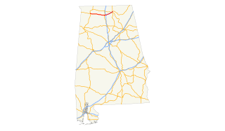
State Route 67 (SR 67) is a 47.107-mile-long (75.811 km) state highway in the U.S. state of Alabama that connects the city of Decatur to U.S. Route 231 at Rainbow Crossing in Blount County. This highway serves as a connector between Decatur and Gadsden.

The Decatur, Alabama Metropolitan Statistical Area is a moderately urban region of North-Central Alabama. The 2008 estimate population is 150,125, one-third of which resides within the boundaries of its core city, Decatur, Alabama. It is also considered to be part of the North, Northwest, and North-Central regions of Alabama.
Alternate U.S. Route 72 exists in Alabama on the south side of the Tennessee River between Muscle Shoals and Decatur, while US 72 follows on the north side of the river between Florence and Athens. US 72A crosses the Tennessee River at Decatur, along with U.S. Highway 31, and follows the entire route of Interstate 565. SR-20 was co-signed with US 72A from Muscle Shoals to Huntsville but has since been truncated to the junction of I-65 just east of Decatur.
Austin High School is located in Decatur, Alabama, United States. It is part of the Decatur City Schools system and enrolls over 1,400 students. Since its establishment in 1962, Austin has been one of two high schools in the Decatur area. It boasts a variety of programs.

Area codes 256 and 938 are telephone numbering plan codes that mostly cover North Alabama as well as some eastern portions of the state.
State Route 24 (SR 24) is a 71-mile-long (114 km) state highway in the northwestern and north-central part of the state. The western terminus of the route is near Red Bay at the Mississippi state line, where it continues as Mississippi Highway 76. The eastern terminus of the route is near the junction with SR 67 at Decatur, where it continues for 2 miles as Moulton Street. Moulton Street ends east of US 31. The route is one of several segments that comprises Corridor V of the Appalachian Development Highway System. Once completed, Corridor V will provide a continuous route between Batesville, Mississippi and Chattanooga, Tennessee.
Interstate 65 (I-65) meanders across 366 miles (589 km) of the Alabama countryside linking six of the state's 10 largest cities. The highway links together many important roadways that make commerce inside and outside of the state's boundaries possible. It starts at I-10 near Mobile. The route passes through the major cities of Montgomery, Birmingham, and Decatur before entering Tennessee in the north near the town of Ardmore, Alabama.
Christopher Columbus Harris represented Alabama's 8th congressional district in the United States House of Representatives.
Caddo is an unincorporated community along Alabama State Highway 24 between Decatur and Moulton in Lawrence County, Alabama, United States. Caddo is a feeder community or suburb of Decatur and is part of both the Decatur Metropolitan Area and the Huntsville-Decatur Combined Statistical Area. Movements to incorporate Caddo have been discussed since the 1980s.

Albany, Alabama, also known as New Decatur, Alabama, was a city in Morgan County, Alabama, United States, situated immediately to the southeast of the city of Decatur near the Tennessee River. New Decatur/Albany existed as a city from 1887 until 1927, when it merged with the city of Decatur. Today, it exists as a neighborhood within the city of Decatur, and is on the National Register of Historic Places.


