Somerville, Alabama

Last updated

Somerville, Alabama
Somerville Courthouse Feb 2012 02.jpg
The Somerville Courthouse was built in 1837 in the Federal style. It served as the county courthouse for Morgan County until the county seat was moved from Somerville to Decatur in 1891. It was listed on the National Register of Historic Places on March 24, 1972.
Morgan County Alabama Incorporated and Unincorporated areas Somerville Highlighted 0171496.svg
Location in Morgan County, Alabama
Coordinates: 34°28′12″N86°47′56″W / 34.47000°N 86.79889°W / 34.47000; -86.79889
Country United States
State Alabama
County Morgan
Incorporated December 3, 1819 [1] [2]
Area
[3]
  Total3.47 sq mi (8.98 km2)
  Land3.46 sq mi (8.97 km2)
  Water0.01 sq mi (0.01 km2)
Elevation
[4]
604 ft (184 m)
Population
 (2020) [5]
  Total796
  Density229.86/sq mi (88.74/km2)
Time zone UTC-6 (Central (CST))
  Summer (DST) UTC-5 (CDT)
ZIP code
35670
Area code 256
FIPS code 01-71496
GNIS feature ID2407365 [4]
Website www.townofsomerville.org

Somerville is a town in Morgan County, Alabama, United States. It is included in the Decatur Metropolitan Area and the Huntsville-Decatur Combined Statistical Area. As of the 2020 census, the population of the town was 796. [5]

Contents

History

Somerville was the county seat of Morgan County from 1818 to 1891, when the seat was moved to Decatur. The town was named for Robert M. Summerville, an officer killed in 1814 during the Creek War. Initially incorporated on December 3, 1819, [2] [1] it is a few days older than the state. After its loss of the county seat in the 1890s, its incorporation lapsed. It was reorganized (reincorporated) on December 1, 1955. [6]
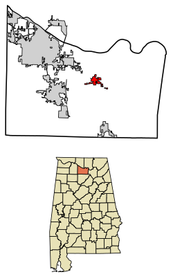
Geography

Somerville is located in central Morgan County at 34°28′12″N86°47′56″W / 34.47000°N 86.79889°W / 34.47000; -86.79889 (34.469961, -86.798782), [7] along Alabama State Route 67, which leads northwest 15 miles (24 km) to Decatur and southeast 18 miles (29 km) to the edge of Baileyton.

According to the U.S. Census Bureau, the town has a total area of 3.5 square miles (9.1 km2), of which 0.005 square miles (3.2 acres), or 0.14%, are water. [3] Somerville is drained by Town Creek, which flows east to Cotaco Creek, a north-flowing tributary of the Tennessee River.

Demographics

Historical population
CensusPop.Note
1850 217
1870 115
1880 20981.7%
1960 166
1970 18511.4%
1980 140−24.3%
1990 21150.7%
2000 34764.5%
2010 724108.6%
2020 7969.9%
U.S. Decennial Census [8]
2013 Estimate [9]

As of the census [10] of 2000, there were 347 people, 148 households, and 97 families residing in the town. The population density was 339.9 inhabitants per square mile (131.2/km2). There were 160 housing units at an average density of 156.7 per square mile (60.5/km2). The racial makeup of the town was 91.35% White, 5.76% Black or African American, 1.73% Native American, 0.29% from other races, and 0.86% from two or more races. 0.58% of the population were Hispanic or Latino of any race.

There were 148 households, out of which 28.4% had children under the age of 18 living with them, 51.4% were married couples living together, 11.5% had a female householder with no husband present, and 33.8% were non-families. 29.7% of all households were made up of individuals, and 8.8% had someone living alone who was 65 years of age or older. The average household size was 2.34 and the average family size was 2.92.

In the town, the population was spread out, with 22.5% under the age of 18, 11.2% from 18 to 24, 33.1% from 25 to 44, 22.5% from 45 to 64, and 10.7% who were 65 years of age or older. The median age was 36 years. For every 100 females, there were 94.9 males. For every 100 females age 18 and over, there were 103.8 males.

The median income for a household in the town was $26,250, and the median income for a family was $31,250. Males had a median income of $29,107 versus $18,958 for females. The per capita income for the town was $13,747. About 13.3% of families and 13.7% of the population were below the poverty line, including 11.0% of those under age 18 and 32.1% of those age 65 or over.

Mayor and city council

Mayor

City Council

Notable people

Related Research Articles

<span class="mw-page-title-main">Morgan County, Alabama</span> County in Alabama, United States

Morgan County is a county in the north-central part of the U.S. state of Alabama. As of the 2020 census, its population was 123,421. The county seat is Decatur. On June 14, 1821, it was renamed in honor of American Revolutionary War General Daniel Morgan of Virginia. It is a prohibition or dry county, although alcohol sales are allowed in the cities of Decatur, Hartselle, and Priceville. Morgan County is included in the Decatur, AL Metropolitan Statistical Area, which is also included in the Huntsville-Decatur-Albertville, AL Combined Statistical Area. It is a part of the North, Northwest, and North-Central regions of Alabama.

<span class="mw-page-title-main">Lawrence County, Alabama</span> County in Alabama, United States

Lawrence County is a county in the northern part of the U.S. state of Alabama. As of the 2020 census, the population was 33,073. The county seat is Moulton. The county was named after James Lawrence, a captain in the United States Navy from New Jersey.

<span class="mw-page-title-main">Marshall County, Alabama</span> County in Alabama, United States

Marshall County is a county of the state of Alabama, United States. As of the 2020 census the population was 97,612. Its county seat is Guntersville. A second courthouse is in Albertville. Its name is in honor of John Marshall, famous Chief Justice of the United States. Marshall County is a dry county, with the exception of the five cities of Albertville, Arab, Grant, Guntersville, and Boaz. Marshall County comprises the Albertville, AL Micropolitan Statistical Area, which is also included in the Huntsville-Decatur-Albertville, AL Combined Statistical Area.

<span class="mw-page-title-main">Arab, Alabama</span> City in Alabama, United States

Arab is a city in Marshall County in the northern part of the U.S. state of Alabama, located 10 miles (16 km) from Guntersville Lake and Guntersville Dam, and is included in the Huntsville-Decatur Combined Statistical Area. The population was 8,461 at the 2020 census.

<span class="mw-page-title-main">Sardis City, Alabama</span> Town in Alabama, United States

Sardis City is a town in Etowah and Marshall counties in the U.S. state of Alabama. It is part of the Gadsden Metropolitan Statistical Area. It originally incorporated in May 1963 under the name of "Sardis". It became Sardis City in the 1980s. At the 2020 census, the population was 1,814.

<span class="mw-page-title-main">Paint Rock, Alabama</span> Town in Alabama, United States

Paint Rock is a town in Jackson County, Alabama, United States, along the Paint Rock River, and is included in the Huntsville-Decatur Combined Statistical Area. It was incorporated in July 1894.

<span class="mw-page-title-main">Woodville, Alabama</span> Town in Alabama, United States

Woodville is a town in Jackson County, Alabama, United States. It was officially established by an act of the Alabama State Legislature on December 13, 1819, one day before Alabama became a state. It was later incorporated on May 12, 1890, but lost its charter in 1897. It reincorporated in 1912. As of the 2010 census, the population of the town is 746, down from 761 in 2000.

<span class="mw-page-title-main">Town Creek, Alabama</span> Town in Alabama, United States

Town Creek is a town in Lawrence County, Alabama, United States, and is included in the Decatur Metropolitan Area, as well as the Huntsville-Decatur Combined Statistical Area. It incorporated in March 1875. As of the 2010 census, the population of the town is 1100, down from 1216 in 2000. Since 1920, it has been the second largest town in Lawrence County after Moulton.

<span class="mw-page-title-main">Elkmont, Alabama</span> Town in Alabama, United States

Elkmont is a town in Limestone County, Alabama, United States, and is included in the Huntsville-Decatur Combined Statistical Area. As of the 2010 census, the population of the town was 434, down from its record high of 470 in 2000.

<span class="mw-page-title-main">Mooresville, Alabama</span> Town in Alabama, United States

Mooresville is a town in Limestone County, Alabama, United States, located southeast of the intersection of Interstate 565 and Interstate 65, and north of Wheeler Lake.

<span class="mw-page-title-main">New Hope, Alabama</span> City in Alabama, United States

New Hope is a city in Madison County, Alabama, United States, and is included in the Huntsville-Decatur Combined Statistical Area. The population was 2,889 at the 2020 census.

<span class="mw-page-title-main">Owens Cross Roads, Alabama</span> Town in Alabama, United States

Owens Cross Roads is a town in Madison County, Alabama, United States, and is included in the Huntsville-Decatur Combined Statistical Area. It was incorporated on October 9, 1967. The population was 2,594 at the 2020 census.

<span class="mw-page-title-main">Douglas, Alabama</span> Town in Alabama, United States

Douglas is a town in Marshall County, Alabama, United States. Douglas, a part of the Huntsville–Decatur Combined Statistical Area, had a population of 761 as of the 2020 census. The town incorporated in 1978.

<span class="mw-page-title-main">Union Grove, Alabama</span> Town in Alabama, United States

Union Grove is a town in Marshall County, Alabama, United States, and is included in the Huntsville-Decatur Combined Statistical Area. As of the 2020 census, the population of the town was 67, down from 77 at the 2010 census.

<span class="mw-page-title-main">Eva, Alabama</span> Town in Alabama, United States

Eva is a town in Morgan County, Alabama, United States, and is included in the Decatur Metropolitan Area and the Huntsville-Decatur Combined Statistical Area. As of the 2020 census, the population of the town was 589, up from 519 in 2010. The mayor currently is Gary Livingston.

<span class="mw-page-title-main">Falkville, Alabama</span> Town in Alabama, United States

Falkville is a town in Morgan County, Alabama, United States, and is included in the Decatur Metropolitan Area and Huntsville-Decatur Combined Statistical Area. As of the 2020 census, the population of the town was 1,197.

<span class="mw-page-title-main">Hartselle, Alabama</span> City in Alabama, United States

Hartselle is the second largest city in Morgan County, Alabama, United States, 13 miles (21 km) south of Decatur. It is part of the Decatur Metropolitan Area and the Huntsville-Decatur Combined Statistical Area.

<span class="mw-page-title-main">Priceville, Alabama</span> City in Alabama, United States

Priceville is the third largest municipality in Morgan County, Alabama, United States and is included in the Decatur Metropolitan Area, as well as the Huntsville-Decatur Combined Statistical Area. The 2020 census counted a population of 3,513, up from 2,658 in 2010.

<span class="mw-page-title-main">Trinity, Alabama</span> Town in Alabama, United States

Trinity is a town in Morgan County, Alabama, United States. It is included in the Decatur Metropolitan Area and the Huntsville-Decatur Combined Statistical Area. As of the 2020 census, the population of the town was 2,526, up from 2,095 in 2010. It was incorporated in 1901.

<span class="mw-page-title-main">Ardmore, Tennessee</span> City in Tennessee, United States

Ardmore is a city in Giles and Lincoln counties, Tennessee, United States. The population was 1,217 at the 2020 census. Ardmore is the site of a Tennessee Department of Tourist Development Welcome Center. It borders its sister city, Ardmore, Alabama.

References

  1. 1 2 http://www.legislature.state.al.us/aliswww/history/acts_and_journals/Acts_Oct_Dec_1819/Page13_pg111-120.html]. "An act to establish the town of Sommerville, in the county of Cotaco."] Journal of the House of Representatives of the General Assembly of the State of Alabama. Cahawba. Printed at the Press Office. 1820. Pages 113-114.
  2. 1 2 "Somerville". encyclopediaofalabama.org.
  3. 1 2 "2021 U.S. Gazetteer Files: Alabama". United States Census Bureau. Retrieved May 2, 2022.
  4. 1 2 U.S. Geological Survey Geographic Names Information System: Somerville, Alabama
  5. 1 2 "Somerville town, Alabama: 2020 DEC Redistricting Data (PL 94-171)". U.S. Census Bureau. Retrieved May 2, 2022.
  6. "Alabama Yesterdays: Somerville's Historic Courthouse". alabamayesterdays.blogspot.com. October 27, 2014.
  7. "US Gazetteer files: 2010, 2000, and 1990". United States Census Bureau. February 12, 2011. Retrieved April 23, 2011.
  8. "U.S. Decennial Census". Census.gov. Retrieved June 6, 2013.
  9. "Annual Estimates of the Resident Population: April 1, 2010 to July 1, 2013" . Retrieved June 3, 2014.
  10. "U.S. Census website". United States Census Bureau . Retrieved January 31, 2008.

Official website