Six Mile, Alabama | |
|---|---|
 Six Mile  Six Mile | |
| Coordinates: 34°25′26″N86°45′23″W / 34.42389°N 86.75639°W | |
| Country | United States |
| State | Alabama |
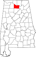
| County | Morgan |
| Elevation | 623 ft (190 m) |
| Time zone | UTC-6 (Central (CST)) |
| • Summer (DST) | UTC-5 (CDT) |
| ZIP code | 35670 (Somerville) |
| Area code | 256 |
| GNIS feature ID | 157067 |
Six Mile is an unincorporated community in Morgan County, Alabama, United States. [1] It is served by the zip code for the nearby town of Somerville.