County Clare is a county in Ireland, in the Mid-West Region and the province of Munster, bordered on the west by the Atlantic Ocean. Clare County Council is the local authority. The county had a population of 118,817 at the 2016 census. The county town and largest settlement is Ennis.
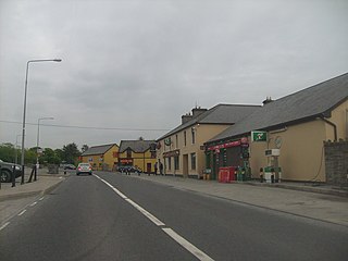
Inagh is a village and civil parish in County Clare, Ireland. It is situated 14 km west of Ennis on the Inagh River. It contains the villages of Inagh and Cloonanaha.

Ennis is the county town of County Clare, Ireland. The Irish name is short for Inis Cluana Rámhfhada. The town is on the River Fergus, north of where it enters the Shannon Estuary, 19 km (12 mi) from Shannon Airport. In 2016, Ennis had a population of 25,276, making it the largest town in Clare and the 12th largest in Ireland.

The island of Ireland, comprising Northern Ireland and the Republic of Ireland, has an extensive network of tens of thousands of kilometres of public roads, usually surfaced. These roads have been developed and modernised over centuries, from trackways suitable only for walkers and horses, to surfaced roads including modern motorways. The major routes were established before Irish independence and consequently take little cognisance of the border other than a change of identification number and street furniture. Northern Ireland has had motorways since 1962, and has a well-developed network of primary, secondary and local routes. The Republic started work on its motorway network in the early 1980s; and historically, the road network there was once somewhat less well developed. However, the Celtic Tiger economic boom and an influx of European Union structural funding, saw national roads and regional roads in the Republic come up to international standard quite quickly. In the mid-1990s, for example, the Republic went from having only a few short sections of motorway to a network of motorways, dual carriageways and other improvements on most major routes as part of a National Development Plan. Road construction in Northern Ireland now tends to proceed at a slower pace than in the Republic, although a number of important bypasses and upgrades to dual carriageway have recently been completed or are about to begin.

Lisdoonvarna is a spa town in County Clare in Ireland. The town is famous for its music and festivals. Although the music festival was discontinued in the 1980s, Lisdoonvarna still hosts its annual matchmaking festival each September. The population was 829 at the 2016 Census.

Ennistymon or Ennistimon is a country market town in County Clare, near the west coast of Ireland. The River Inagh, with its small rapids known as the Cascades, runs through the town, behind the main street. A bridge across the river leads to nearby Lahinch, on the N67 national secondary road. The town is connected to Ennis by the N85, continuing the settlement's main street.

Lahinch or Lehinch is a small town on Liscannor Bay, on the northwest coast of County Clare, Ireland. It lies on the N67 national secondary road, between Milltown Malbay and Ennistymon, roughly 75 kilometres (47 mi) by road southwest of Galway and 68 kilometres (42 mi) northwest of Limerick. The town is a seaside resort and is home to the Lahinch Golf Club. It has become a popular surfing location.

The N18 road is a national primary road in Ireland, connecting the cities of Limerick and Galway. Ennis and Gort are two major towns on the route, and Shannon Airport is reached via the connecting N19. The west coast route continues on to Sligo as the N17. The section from Limerick to the N19 junction forms part of European route E20, and the entire route is part of the proposed Atlantic Corridor. The section of motorway from Shannon to Claregalway is designated the M18 motorway. The tolled Limerick Tunnel forms part of the route.

The N19 road is a national primary road in Ireland, connecting from the N18 Limerick–Ennis–Galway road to Shannon Airport. It forms part of European route E20.

The R445 road is a regional road in Ireland. The route is a non-motorway alternative route to the N7/M7 motorway between Naas and Limerick, and at 170 km it is one of the longest regional roads in Ireland. Indeed, much of the route comprises roads that were formerly part of the N7 between the cities, prior to motorway and other bypasses. Some of the R445 route also comprises local link roads to new N7/M7 route sections.

A national secondary road is a category of road in Ireland. These roads form an important part of the national route network but are secondary to the main arterial routes which are classified as national primary roads. National secondary roads are designated with route numbers higher than those used for primary roads, but with the same "N" prefix. Routes N51 and higher are all national secondary roads.

Fanore is a small village in County Clare, on the west coast of Ireland. The area was officially classified as part of the West Clare Gaeltacht, an Irish-speaking community, until 1956.

Doora is a civil parish and village in County Clare, Ireland, just to the east of the town of Ennis. It is part of the Catholic parish of Doora Barefield. Parts of Doora are contained in the town of Ennis.

Kilnamona is a village and a civil parish in County Clare, Ireland. It is situated north-west of Ennis.

The N68 road is a national secondary road in Ireland. It runs from Ennis to Kilrush. It is entirely in County Clare.
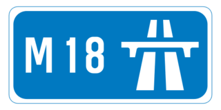
The M18 motorway is an inter-urban motorway in Ireland, forming part of the Limerick, Ennis to Galway national primary road, which, in turn, forms part of the Atlantic Corridor called for as part of the Transport 21 project.

The R476 road is a regional road in central County Clare in Ireland. The route connects the N85 road at Ennis to the N67 road at Lisdoonvarna, 31 kilometres (19 mi) away.

The Burren and Cliffs of Moher Geopark is an internationally designated area of geological interest in The Burren region of County Clare, Ireland. It is the third Geopark to be designated in Ireland, and is recognised at both European and global levels.

Kilmanaheen is a civil parish in County Clare, Ireland. It contains the market town of Ennistymon.