R445 road (Ireland)

Last updated

IRL R445.svg
R445 road
Bóthar R445
NewbridgeRoad.JPG
The R445 dual carriageway between Naas and Newbridge
Route information
Length170 km (110 mi)
Location
Country Ireland
Primary
destinations
Highway system

The R445 road is a regional road in Ireland. The route is a non-motorway alternative route to the N7/M7 motorway between Naas and Limerick, and at 170 km it is one of the longest regional roads in Ireland (longer than most national roads). Indeed, much of the route comprises roads that were formerly part of the N7 between the cities, prior to motorway and other bypasses. Some of the R445 route also comprises local link roads to new N7/M7 route sections.

Contents

Route

The official description of the R445 from the Roads Act 1993 (Classification of Regional Roads) Order 2012 [1] reads:

R445: Naas, County Kildare — Portlaoise, County Laois — Roscrea, Nenagh, County Tipperary — Limerick — Crathloemoyle, County Clare (Part Old National Routes 7 and 18)

Between its junction with N7 at Maudlings in the county of Kildare and its junction with N80 at Stradbally Road in the town of Portlaoise in the county of Laois via Dublin Road, Poplar Square, Main Street and Limerick Road in the town of Naas: Newhall, Buckleys Cross: Liffey Bridge, Main Street and Edward Street in the town of Droichead Nua; and Ballymany Cross; Dublin Street and Claregate Street in the town of Kildare; Cherryville Cross, Mayfield (including link road to M7); Mooreabbey and Dublin Street in the town of Monasterevin; and Clogheen in the county of Kildare: Kilinure, Ballybrittas, Cappakeel, New Inn Cross, Greatheath, Ballydavis; Rathbrennan and Dublin Road in the town of Portlaoise in the county of Laois

and

between its junction with N80 at Abbeyleix Road in the town of Portlaoise and its junction with N62 at Benamore in the county of North Tipperary via Grattan Street in the town of Portlaoise; Clonboyne, Cloncourse; Portlaoise Road, Main Street, Market Square, Bridge Street and Patrick Street at Mountrath; Holy Cross, Moorefield Cross, Rush Hall, Derrin Cross, Borris-in-Ossory and Ballaghmore Lower in the county of Laois: and Cooleeshill in the county of Offaly

and

between its junction with the N62 at Parkmore in the county of North Tipperary and its junction with N52 at Tullahedy via Inane in the county of North Tipperary Ouris and Busherstown in the county of Offaly: Greenhills in the county of North Tipperary: Moneygall in the county of Offaly: Toomevara, Clashnevin, Lisbunny: Dublin Road, Thomas MacDonagh Street, Pearse Street, Kickham Street, Ashe Road and Clare Street in the town of Nenagh: and Springfort Cross in the county of North Tipperary

and

between its junction with N52 at Lissenhall in the county of North Tipperary and its junction with the N18 at Cratloemoyle in the county of Clare via Ballinteenoe, Kilmastulla, Gortybrigane and Birdhill in the county of North Tipperary: Dalys Cross, Mountshannon, Annacotty and Groody Bridge in the county of Limerick: Parkway Roundabout, Dublin Road, Clare Street, Lock Quay, Abbey River Bridge, Northern Relief Road, Castle Street, Thomond Bridge, High Road, Sexton Street North, Northern Ring Road, Ennis Road, Caherdavin Cross and Ennis Road in the city of Limerick: Lansdowne Bridge at the boundary between the city of Limerick and the County of Clare: and Meelick in the county of Clare.

Dublin to southwest of Newbridge

Ancillary roads constructed as part of the N7 Naas Road widening and junction separation scheme are classified as the R445. These offer local access to Johnstown and Kill. They connect to the existing R445 at Maudlin's Interchange (Junction 9 on the N7, start of the M7 motorway).

Here the R445 route follows the Dublin Road into Naas (this route was the N7 prior to the construction of the M7 in 1983). The route continues through Naas along Poplar Street and Main Street, before leaving the town along the Limerick Road. South of Naas, the R445 becomes a dual carriageway for 8 km (5.0 mi) and crosses the M7 motorway at Junction 10, continuing west to Newbridge along the town's Dublin Road, crossing the River Liffey via Liffey Bridge onto Main Street. The route continues along Edward Street, leaving the town as the Kildare Road. The R445 links to the M7 motorway at Junction 12, and crosses the Curragh beside the motorway before veering into Kildare Town. The route sections through Newbridge and Kildare formed the N7 until the extension of the M7 motorway between Junction 10 and Junction 13.

R445 through Kildare, Monasterevin and Portlaoise

The R445 through The Curragh between Kildare and Newbridge R455Curragh.JPG
The R445 through The Curragh between Kildare and Newbridge

The R445 continues on the Dublin Road east of Kildare. This runs through the town via Dublin Street, Claregate Street and the Limerick/Cork Road. The R445 meets Junction 14 of the M7 motorway at Mayfield. From here, the route continues west through Monasterevin via Mooreabbey and Dublin Street. The R445 passes through Ballybrittas on the way to Portlaoise, meeting the M7 motorway again at Junction 16. The Dublin Road brings the R445 into Portlaoise where it joins the N80. The R445 begins again where it leaves the N80 at the junction of Grattan Street and Abbeyleix Road, following the former street out of the town, to meet the M7/N7 at Junction 18. The R445 route from east of Kildare to west of Portlaoise consists of redesignated roads which formed part of the N7 route prior to the opening of the M7 Kildare Bypass (2003), Monasterevin Bypass (2004) and Portlaoise Bypass (1997).

R445 sections between Portlaoise and Limerick

The R445 when it was still the N7 in 2003, just east of Junction 15 looking west July 2003 - R445 (when N7) 003.jpg
The R445 when it was still the N7 in 2003, just east of Junction 15 looking west

In 2010 all of the old N7 route between Portlaoise and Limerick was replaced with motorway and was reclassified as R445. The first section through Mountrath, Castletown and Borris-in-Ossory was reclassified in May 2010 followed the opening of the M7/M8 tolled motorway.

Following the bypass of Nenagh in 2000, and resulting realignment of the N7, the old route through the town was reclassified as part of the R445. The R445 passes through Nenagh via the Dublin Road, Thomas MacDonagh Street, Pierce Street, Kickham Street, Ash Road and Clare Street. The route meets the N52 west of Nenagh. From the Carrigatogher Roundabout the R445 leaves the N52 road and continues along the old N7 route to Birdhill which was redesignated in April 2010. The route between Birdhill and Annacotty was redesignated as R445 in September 2010 following the opening of the Birdhill to Limerick section of the M7.

On 22 December 2010, following the opening of the M7 Castletown to Nenagh motorway project the old N7 route was reclassified as R445 from Borris-in-Ossory to Nenagh passing through the towns of Roscrea, Moneygall and Toomevara.

R445 through Limerick


Finally, the route through Limerick city, which formed the N7 prior to the opening of the Southern Ring Road in 2004, is also now the R445.

The route passes by Annacotty, and enters Limerick along the Dublin Road through Castletroy. The road crosses the Groody Bridge at the beginning of a new road section also opened in 2004 (also designated the N7 at the time). This brings the Dublin Road and R445 to the Parkway Roundabout, where it meets the Childers Road . The R445 continues as the Dublin Road, Clare Street and Lock Quay before crossing the Abbey Bridge across the Abbey River. The R445 passes through King's Island as the Northern Relief Road and Castle Street (passing by King John's Castle). The route crosses the River Shannon via Thomond Bridge and follows High Street, Sexton Street and the Northern Ring Road (past LIT). At Caherdavin Cross (Ivan's Cross) the route follows the Ennis Road west out of the city to meet the N18 in County Clare at the Coonagh Roundabout.

See also

Related Research Articles

<span class="mw-page-title-main">Roads in Ireland</span> Overview of roads in Ireland

The island of Ireland, comprising Northern Ireland and the Republic of Ireland, has an extensive network of tens of thousands of kilometres of public roads, usually surfaced. These roads have been developed and modernised over centuries, from trackways suitable only for walkers and horses, to surfaced roads including modern motorways. Driving is on the left-hand side of the road. The major routes were established before Irish independence and consequently take little cognisance of the border other than a change of identification number and street furniture. Northern Ireland has had motorways since 1962, and has a well-developed network of primary, secondary and local routes. The Republic started work on its motorway network in the early 1980s; and historically, the road network there was once somewhat less well developed. However, the Celtic Tiger economic boom and an influx of European Union structural funding, saw national roads and regional roads in the Republic come up to international standard quite quickly. In the mid-1990s, for example, the Republic went from having only a few short sections of motorway to a network of motorways, dual carriageways and other improvements on most major routes as part of a National Development Plan. Road construction in Northern Ireland now tends to proceed at a slower pace than in the Republic, although a number of important bypasses and upgrades to dual carriageway have recently been completed or are about to begin.

The N7 road is a national primary road in Ireland, connecting Limerick and Dublin. The majority of the route is motorway standard and is designated as the M7 motorway. At the Rosbrien interchange in Limerick the route continues as the N18 dual carriageway to Shannon and Ennis. The road passes through the midlands of Ireland, and acts as a trunk route out of Dublin for the N8 and N9 national primary routes to Cork and Waterford respectively. It forms part of European route E20.

<span class="mw-page-title-main">M7 motorway (Ireland)</span> Motorway in Ireland

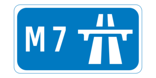
The M7 motorway is a motorway in Ireland. The motorway runs continuously from the outskirts of Naas in County Kildare to Rossbrien on the outskirts of Limerick City. The M7 forms part of the Dublin to Limerick N7 national primary road. The section of the motorway bypassing Naas, an 8 km stretch, was the first section of motorway to open in Ireland, in 1983. Following substantial works to extend the M7 to Limerick, by the end of 2010, the motorway replaced all of the old single-carriageway N7 route which is now designated as R445. At 166.5 km, the M7 is the longest motorway in Ireland.

The N8 road is a national primary road in Ireland, connecting Cork with Dublin via the M7. The N8 is further classified by the United Nations as the entirety of the European route E 201, part of the trans-Europe International E-road network. The road is motorway standard from junction 19 on the M7 to the Dunkettle interchange in Cork City and is designated as the M8 motorway. From here the route continues into Cork city centre and terminates at the N22 road at St. Patrick's Street. The M8 motorway was completed in May 2010, replacing the single carriageway sections of the old N8 and bypassing towns on the main Cork to Dublin road. It is now possible to travel from Cork to Dublin on the M/N8 in about 2 hours 30 minutes. The route commences just south of Portlaoise, and reaches Cork via the midlands and the Golden Vale of Ireland, through Counties Laois, Kilkenny, Tipperary, Limerick and Cork.

<span class="mw-page-title-main">National Development Plan</span> Large infrastructure developments in Ireland

National Development Plan was the title given by the Irish Government to a scheme of organised large-scale expenditure on (mainly) national infrastructure. The first five-year plan ran from 1988 to 1993, the second was a six-year plan from 1994 to 1999 and the third ran as a seven-year plan from 2000 to 2006. A fourth National Development Plan ran from 2007 to 2011. The main elements of the third plan were the development of a national motorway network between the major cities in Ireland. The upgrading of the rail network was a secondary scheme.

<span class="mw-page-title-main">Monasterevin</span> Town in County Kildare, Ireland

Monasterevin, also Monasterevan, and Mevin is a town in County Kildare, Ireland. The town lies on the River Barrow and the Barrowline, a canal branch of the Grand Canal. The population was 4,246 at the 2016 Census.

<span class="mw-page-title-main">Ballybrittas</span> Village in Leinster, Ireland

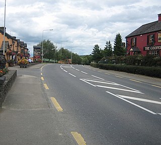
Ballybrittas is a small village in the northeast of County Laois, Ireland situated on the R445 about 5 km SW of Monasterevin, County Kildare. Formerly on the N7 Dublin - Limerick road, the village is now bypassed by the M7 motorway.

<span class="mw-page-title-main">Regional road (Ireland)</span> Class of road in Ireland

A regional road in the Republic of Ireland is a class of road not forming a major route, but nevertheless forming a link in the national route network. There are over 11,600 kilometres of regional roads. Regional roads are numbered with three-digit route numbers, prefixed by "R". The equivalent road category in Northern Ireland are B roads.

<span class="mw-page-title-main">Ballybrophy railway station</span> Railway station in Ballybrophy, Ireland

Ballybrophy is a railway station in the village of Ballybrophy, County Laois, Ireland, halfway between Borris-in-Ossory and Rathdowney in the Barony of Clandonagh.

<span class="mw-page-title-main">R639 road (Ireland)</span> Road in Ireland

The R639 road is one of Ireland's regional roads. Once designated the N8 national primary road, it was reclassified in stages as the R639 following the progressive opening of sections of the M8 motorway, which rendered the single carriageway N8 redundant as a national primary road. By-passed sections of the old N8 were generally reclassified as R639 as soon as a new section of M8 opened, thereby increasing the length of the R639. With the completion of the M8 on 28 May 2010, the R639 now stretches from Durrow, County Laois to Cork, running through counties Laois, Kilkenny, Tipperary, Limerick and Cork.

<span class="mw-page-title-main">Annacotty</span> Town near Limerick City, Ireland

Annacotty is a suburban town on the outskirts of Limerick, Ireland, 7 km (4 mi) from the centre of the city. It is situated where the old N7 main road between Limerick and Dublin crosses the Mulkear River, 1 km (0.6 mi) upstream of where it flows into the River Shannon.

<span class="mw-page-title-main">Moneygall</span> Village in Leinster, Ireland

Moneygall is a small village on the border of counties Offaly and Tipperary, in Ireland. It is situated on the R445 road between Dublin and Limerick. There were 313 people living in the village as of the 2016 census. Moneygall has a Catholic church, motorway service station, a car sales and repair centre, a national school, a Garda station and two pubs. The nearest Church of Ireland church, Borrisnafarney, is 2 km from the village beside the former Loughton Demesne.

<span class="mw-page-title-main">Birdhill</span> Town in County Tipperary, Ireland

Birdhill is a village in County Tipperary, Ireland. It is in the barony of Owney and Arra and is part of the parish of Newport, Birdhill and Toor in the Roman Catholic Archdiocese of Cashel and Emly. Its Irish name was historically anglicised as Knockan or Knockaneeneen.

<span class="mw-page-title-main">R421 road (Ireland)</span> Road in Ireland

The R421 road is a regional road in Ireland which runs southwest-northeast from the R445 south of Roscrea to the N52 north of Tullamore. The route also passes through Clareen, Kinnitty and Killurin. The bulk of the route is in County Offaly with small sections in counties Tipperary and Laois. The route is 50 km (31 mi) long.

<span class="mw-page-title-main">R494 road (Ireland)</span> Road in Ireland

The R494 road is a regional road in Ireland which runs southwest-northeast from Junction 27 of the M7 at Birdhill, County Tipperary to the N52 at Nenagh - all in County Tipperary. It leaves the M7 and loops around the Arra Mountains between the hills and Lough Derg returning to what was the N7 in Nenagh.

<span class="mw-page-title-main">R448 road (Ireland)</span> Road in Ireland

The R448 road is a regional road in Ireland. It is the designation given to the former N9 national primary road when it was bypassed by the M9 motorway.

<span class="mw-page-title-main">2008 Ireland floods</span>

The 2008 Irish flash floods were a series of flash floods that occurred across the island of Ireland in August 2008. The floods and related weather conditions primarily affected the following counties; Limerick, Cork, Dublin, Antrim, Carlow, Galway, Laois, Louth, Meath, Kildare, Kilkenny, Tipperary, Offaly, Sligo and Donegal. Parts of Ireland's large urban centres, including Dublin and Belfast, were submerged, whilst Carlow town has experienced some of the worst flooding in the country. One person died; 31-year-old dad-of-one Przemyslaw Jablonski. He went missing in the River Fergus, in Ennis, and was found 6 days later in the same river. He was pronounced dead at the scene.

<span class="mw-page-title-main">Motorways in the Republic of Ireland</span>

In Ireland, the highest category of road is a motorway, indicated by the prefix M followed by a one- or two-digit number. The motorway network consists entirely of motorway-grade dual carriageways and is largely focused upon Dublin. There are also several three-lane motorways, while Ireland's busiest road, the M50, incorporates four-lane, five-lane, and six-lane stretches.

References