
The counties of Ireland are historic administrative divisions of the island. They began as Norman structures, and as the powers exercised by the Cambro-Norman barons and the Old English nobility waned over time, new offices of political control came to be established at a county level. The number of counties varied depending on the time period, however thirty-two is the traditionally accepted and used number.
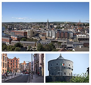
Drogheda is an industrial and port town in County Louth on the east coast of Ireland, 56 km (35 mi) north of Dublin. It is located on the Dublin–Belfast corridor on the east coast of Ireland, mostly in County Louth but with the south fringes of the town in County Meath, 49 km (30 mi) north of Dublin. Drogheda had a population of approximately 41,000 inhabitants in 2016, making it the eleventh largest settlement by population in all of Ireland, and the largest town in the Republic of Ireland by both population and area. It is the last bridging point on the River Boyne before it enters the Irish Sea. The UNESCO World Heritage Site of Newgrange is located 8 km (5.0 mi) west of the town.

Swords, the county town of Fingal, is a large suburban town on the east coast of Ireland, situated ten kilometres north of Dublin city centre. The town was reputedly founded c. AD 560. Located on the Ward River, Swords features Swords Castle, a restored medieval castle, a holy well from which it takes its name, a round tower and a Norman tower. Facilities in the area include the Pavilions shopping centre, one of the largest in the Dublin region, a range of civic offices, some light industries, the main storage facility and archive of the National Museum of Ireland and several parks. Dublin Airport is located nearby.
The M1 motorway is a motorway in Ireland. It forms the large majority of the N1 national primary road connecting Dublin towards Belfast along the east of the island of Ireland. The route heads north via Swords, Drogheda and Dundalk to the Northern Irish border just south of Newry in County Armagh, where it joins the A1 road and further on, the M1 motorway in Northern Ireland. It also forms a significant part of the road connection between Dublin and the Northern Irish cities of Newry, and Lisburn. The route is part of European route E01.

A regional road in the Republic of Ireland is a class of road not forming a major route, but nevertheless forming a link in the national route network. There are over 11,600 kilometres of regional roads. Regional roads are numbered with three-digit route numbers, prefixed by "R". The equivalent road category in Northern Ireland are B roads.

The R148 road is one of Ireland's regional roads which was classified following the opening of a by-passed national primary road.

The River Tolka, also once spelled Tolga, is one of Dublin's three main rivers, flowing from County Meath to Fingal within the old County Dublin, and through the north of Dublin city, Ireland. By flow of water, the Tolka is the second largest river in Dublin, following the Liffey, but runs more slowly than the Dodder.
The R132 road is one of Ireland's newest regional roads, having been classified following the opening M1 motorway which by-passes most of the old N1 route. The R132 is 98.9 kilometres (61.5 mi) long.

Naul, is a village, townland, and civil parish at the northern edge of Fingal and the traditional County Dublin in Ireland. The Delvin River to the north of the village marks the county boundary with County Meath. Naul civil parish is in the historic barony of Balrothery West.
The R135 road is one of Ireland's newest regional roads, being a reclassification of those sections of the former N2 which were bypassed when the N2(M2) Ashbourne By-Pass dual carriageway opened in 2006, and when the Carrickmacross, Castleblayney & Monaghan bypasses were completed.

The 2008 Irish flash floods were a series of flash floods that occurred across the island of Ireland in August 2008. The floods and related weather conditions primarily affected the following counties; Limerick, Cork, Dublin, Antrim, Carlow, Galway, Laois, Louth, Meath, Kildare, Kilkenny, Tipperary, Offaly, Sligo and Donegal. Parts of Ireland's large urban centres, including Dublin and Belfast, were submerged, whilst Carlow town has experienced some of the worst flooding in the country. One person died; 31-year-old dad-of-one Przemyslaw Jablonski. He went missing in the River Fergus, in Ennis, and was found 6 days later in the same river. He was pronounced dead at the scene.

The R125 road is a regional road in Ireland, linking Kilcock on the County Meath / County Kildare border to Swords in County Dublin via the towns of Dunshaughlin and Ratoath.

The R147 is a regional road in Ireland. Its first section runs from St Peters Church in Phibsborough, Dublin to its junction with the M50. It then follows the route of a former section of the N3 between Clonee and Kells. It serves as an alternative route for non-motorway traffic and traffic wishing to avoid tolls on the M3.

The R102 road is a regional road in Dublin, Ireland, which describes a broad arc across the north of the city, connecting the N3 — at its M50 motorway intersection — to the R107 on the other side of the city.

The R104 road is a regional road in north Dublin, Ireland. The road passes through Finglas, Santry, and Coolock, along the northern edge of Raheny and finishes at the coast in Kilbarrack.
The R105 road is a regional road in north Dublin, Ireland. It travels from the city centre to Howth, and loops at both ends; the road fully encircles Howth Head. Along the way, the road passes through Fairview, the western end of Clontarf, Killester, Raheny, the coastal edge of Kilbarrack and Sutton. Its biggest component is Howth Road.

The R121 road is a regional road in south County Dublin and Fingal, Ireland.

The R122 road is a regional road in Dublin, Ireland.
The R130 road is a regional road in Fingal, Ireland.

The R809 road is a regional road in three sections in Dublin and Fingal, Ireland. It connects the R807 in Bettyglen to the R105 in Sutton following a roughly semicircular path that runs north, then east, then south, connecting one point on the coast road of Dublin Bay with another point, further northeast.


