The N7 road is a national primary road in Ireland, connecting Limerick and Dublin. The majority of the route is motorway standard and is designated as the M7 motorway. At the Rosbrien interchange in Limerick the route continues as the N18 dual carriageway to Shannon and Ennis. The road passes through the midlands of Ireland, and acts as a trunk route out of Dublin for the N8 and N9 national primary routes to Cork and Waterford respectively. It forms part of European route E20.

The N11 road is a national primary road in Ireland, running for 129 km (80 mi) along the east side of Ireland from Dublin to Wexford. It passes close to Bray, Greystones, Wicklow, Arklow, Gorey, and Enniscorthy. Beyond Wexford, the route continues to Rosslare as the N25. The road forms part of European route E01. As of July 2019 the N11/M11 is of dual carriageway or motorway standard from Dublin as far as Oilgate in County Wexford.
Rathfarnham is a Southside suburb of Dublin, Ireland. It is south of Terenure, east of Templeogue, and is in the postal districts of Dublin 14 and 16. It is within the administrative areas of both Dún Laoghaire–Rathdown County Council and South Dublin County Council.

The N4 road is a national primary road in Ireland, running from Dublin to the northwest of Ireland and Sligo town. The M6 to Galway diverges from this route after Kinnegad, while the N5 to Westport diverges at Longford town. Most sections of the N4 that are motorway-standard are designated the M4 motorway.

Churchtown is a largely residential suburb on the southside of Dublin, between Rathfarnham and Dundrum.

The R509 road, the Childers Road, is a regional road in Ireland, running through the southeastern side of Limerick City. It forms what is somewhat akin to an inner ring road.

The R113 road is a regional road in Ireland. Located in Dublin, it forms a semi-orbital route around the south of the city. As of 2007, clockwise, it starts at the N31 at Temple Hill in Blackrock and ends at a junction with the N4 at Palmerstown.
Nutgrove is an area in Churchtown, County Dublin.

The N31 road is a national primary road in Ireland. It connects the harbour at Dún Laoghaire southeast of Dublin to the national route network. Both the N11 and Dublin's M50 C-ring motorway connect to the N31.
The R136 road is a regional road in Ireland, located in the southwest of Dublin. Named the Outer Ring Road, the route, which is dual carriageway, runs from the N4 at Lucan to the N81 at Tallaght, bypassing west of Clondalkin and crossing the N7 near Citywest. It was built as part of the planning for the new town of Adamstown.

The R115 road is a regional road in counties Dublin and Wicklow in Ireland. It follows the Military Road for its entire length. The R115 is 40.5 km (25.2 mi) long; the full length of the Military Road is 57.9 km (36.0 mi).

The R112 road is a regional road in south Dublin, Ireland. It begins at the junction with the R148 road at Chapelizod and arcs southeastwards, then eastwards across the middle of south Dublin, ending at the Mount Merrion junction of the R138. The road is a single carriageway, with cycle lanes on some stretches. Improvements to the road have been made over the last 10 years, the most significant being at Dundrum Cross where the road was widened to make room for the new Luas bridge and Dundrum bypass.

The R825 road is a regional road in south Dublin, Republic of Ireland. The road starts in Clonskeagh at the junction with the R117 and passes through Goatstown, Kilmacud and Stillorgan before ending at a junction with the N31 in Blackrock, County Dublin. The route is 7.6 km (4.7 mi) in length and is single carriageway apart from a small 2 lane section beside the N11.

The R826 road is a regional road in south Dublin, Ireland. The road runs from the Dundrum junction of the M50 as passes through or near Ballinteer, Dundrum and Balally before terminating at the junction with the R112 close to Goatstown. The route runs on mostly new road, built to facilitate the M50 and Dundrum Town Center and is 2.5 km long.

The R824 road is a regional road in south Dublin, Ireland. The road starts somewhere between Sandford and Clonskeagh, passes through Donnybrook and finishes at the junction with the Merrion Road and Ailesbury Road close by to Sydney Parade.

The R822 road is a regional road in south Dublin, Ireland. The road starts at the junction with the R821 in Rathfarnham before terminating with the junction with Taylor's Lane on the R113. The road is known as Grange Road throughout.
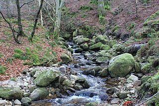
The Owendoher River is a small river in southern County Dublin, Ireland, the largest tributary of the River Dodder, and a part of the River Liffey system.

The R138 road is a regional road in Ireland. It commences at the south end of O'Connell Bridge in Dublin city centre. It proceeds along D'Olier Street, College Street.

The R139 road is a regional road in Ireland, located in the east of Dublin.