
Wrexham is a large market town and the administrative centre of Wrexham County Borough in Wales. It is located between the Welsh mountains and the lower Dee Valley where it borders with the county of Cheshire in England. Historically in the county of Denbighshire, the town became part of the county of Clwyd in 1974 and then the principal settlement of the Wrexham County Borough in 1996.

Flintshire is a county in the north-east of Wales. It borders the English county of Cheshire to the east, Denbighshire to the west and Wrexham County Borough to the south. It is named after the historic county of the same name which has notably different borders. Flintshire is considered part of the Welsh Marches and formed part of the historic Earldom of Chester and Flint. The county is governed by Flintshire County Council which has its main offices in County Hall, Mold.

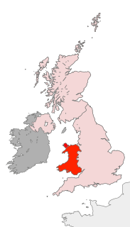
Wrexham County Borough is a county borough in the north-east of Wales. The county borough has a population of nearly 135,000 inhabitants, with around 63,000 residing in either the town of Wrexham, the surrounding conurbation of urban villages around Wrexham, or the two other urban towns in the county borough, Chirk and Holt. The remainder live to the south and east of the town in more rural areas, including the county borough's large salient into the Ceiriog Valley. The area has strong links with coal-mining and was formed on 1 April 1996 following the enactment of the Local Government (Wales) Act 1994. Borough status was inherited from the town of Wrexham, granted over 150 years ago. Most of the area was previously part of the district of Wrexham Maelor – with several communities coming from Glyndŵr – in the county of Clwyd.

Ruabon is a village and community in Wrexham County Borough, Wales. The name comes from Rhiw Fabon, rhiw being the Welsh word for "slope" or "hillside" and Fabon being a mutation from St Mabon, the original church name, of earlier, Celtic origin. An older English spelling, Rhuabon, can sometimes be seen.

Coedpoeth is a large village and community in Wrexham County Borough, Wales. The built-up area with Minera had a population of 5,723 in the 2011 census.

Acton is a community in Wrexham County Borough, Wales. It lies in the north-eastern part of the market town of Wrexham. The area is largely residential and at its centre, lies Acton Park, the location of the former Acton Hall.

The River Clywedog is a river in the county borough of Wrexham, Wales. Its uses have been watering crops, powering industrial machinery but is now used as walking trails or geography trips. The river originates to the west of Wrexham, and joins the River Dee some four miles south east of the Town.

Bwlchgwyn is a village in Wrexham County Borough, Wales, on the A525 road, 5 miles (8 km) west of the town of Wrexham and 10 miles (16 km) south-east of the town of Ruthin. Bwlchgwyn is part of the community of Brymbo. In the 2011 Census the population of the village was 855.

Brymbo is a large village and community in Wrexham County Borough, Wales. It lies in the hilly country to the west of Wrexham town, largely surrounded by farmland.

The River Cegidog is a river in north-east Wales. It flows mainly through Flintshire but towards the end of its course it forms the border between Flintshire and Wrexham County Borough.

Bersham is a small Welsh village in the suburbs of the county borough of Wrexham that lies next to the River Clywedog, and in the community of Esclusham. Wrexham owes a large amount of its original industrial heritage to Bersham, but despite this the village still retains a rural feeling.

The Clywedog Trail is a 9-mile (14 km) footpath close to Wrexham in Wales. Starting at the Minera Lead Mines (53.0512°N 3.0811°W) and running to King's Mills (53.0358°N 2.9750°W), it follows the course of the River Clywedog. It is a haven for walking, relaxation and enjoying the peace of the wildlife. It is said that the Clywedog Valley was the Silicon Valley of the 18th century, as it was there that British ironmaking began in 1670, smelting iron ore with coke began in 1721 and John Wilkinson set up shop in 1761. For many years the area was one of the most important iron manufacturing centers in the world.

Johnstown is a village in the county borough of Wrexham, Wales, and forms part of the old coal mining community of Rhosllannerchrugog. It is thought to have been named after John Bury, a mid 19th century member of Wrexham's first Town Council, who built a number of houses in the area.

Cheshire West and Chester is a unitary authority with borough status in the ceremonial county of Cheshire, England. It was established on 1 April 2009 as part of the 2009 local government changes, by virtue of an order under the Local Government and Public Involvement in Health Act 2007. It superseded the boroughs of Ellesmere Port and Neston and Vale Royal and the City of Chester; its council assumed the functions and responsibilities of the former Cheshire County Council within its area. The remainder of ceremonial Cheshire is composed of Cheshire East, Halton and Warrington.
Wrexham has two main town parks, these being Bellevue Park and Acton Park, and open parkland at Erddig. With the rapid development of the town in the 19th century, the need for a formal park for the growing population was identified. However it was not until 1906 that the location for the new park was agreed upon. The 'Parciau' or Bellevue Park as it became known, was built alongside the old cemetery on Ruabon Road. The park was designed to commemorate the Jubilee year of the Incorporation of Wrexham.
Borough United were a minor Welsh football club based in Llandudno Junction who caused a shock by winning the Welsh Cup in 1963 before performing much better than anticipated in European football.
Scouting in Wales provides an overview of Scouting activities in Wales. Scout troops have existed in the country since 1908 with the largest number of Scouts and volunteer leaders today linked to the Scout Association of the United Kingdom. This is done through ScoutsCymru, the Welsh Scout Council who split the region further into four regions and a total of 12 Scout Areas. In addition to the Scout Association, there are also traditional Scouting groups belonging to the Baden-Powell Scouts' Association and a number of Scouting clubs within Universities which are affiliated to the Student Scout and Guide Organisation.

Bradley is a village in Wrexham County Borough, Wales. Situated in the community of Gwersyllt, it is bounded by Alyn Waters Country Park to the north, the village of Gwersyllt to the west and south, and Bradley Hill, Wat's Dyke and the River Alyn to the east. The Bradley Built-up Area Sub-division (BUASD) is a subdivision of the Wrexham Built-up Area.

The River Eitha is a small river in Wrexham County Borough, Wales. It is part of the River Dee catchment. Its name was probably derived from the Welsh word eithaf - "extremity", "farthest".

Nant-y-Ffrith refers to a stream and the wooded valley through which it flows on the border between Flintshire and Wrexham County Borough in Wales. The stream begins in moorland to the east of Llandegla. It passes Bwlchgwyn village before entering a rather steep-sided, rocky valley. It passes under the viaduct of a disused railway line before joining the River Cegidog at Ffrith.


