The River Clwyd is a river in Wales that rises in the Clocaenog Forest 5 mi (8 km) northwest of Corwen. Its total length is 35 mi (56 km).
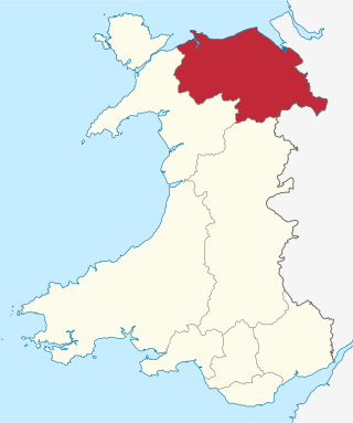
Clwyd is a preserved county of Wales, situated in the north-east corner of the country; it is named after the River Clwyd, which runs through the area. To the north lies the Irish Sea, with the English ceremonial counties of Cheshire to the east and Shropshire to the south-east. Powys and Gwynedd lie to the south and west respectively. Clwyd also shares a maritime boundary with Merseyside along the River Dee. Between 1974 and 1996, a slightly different area had a county council, with local government functions shared with six district councils. In 1996, Clwyd was abolished, and the new principal areas of Conwy County Borough, Denbighshire, Flintshire and Wrexham County Borough were created; under this reorganisation, "Clwyd" became a preserved county, with the name being retained for certain ceremonial functions.

The River Dee is a river flowing through North Wales, and through Cheshire, England, in Great Britain. The length of the main section from Bala to Chester is 113 km and it is largely located in Wales. The stretch between Aldford and Chester is within England, and two other sections form the border between the two countries.

Mynydd Isa is a village in Flintshire, in north-east Wales. It lies between the county town of Mold, and Buckley in the community of Argoed which had a population of 5837 according to the 2011 census. Mynydd Isa was originally a small hamlet on the north side of the Mold to Buckley road just downhill from the now demolished Calvinist chapel. It did not appear on Ordnance Survey maps until 1912.

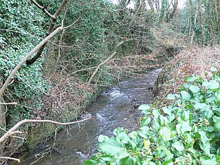
The River Alyn is a tributary of the River Dee in north-east Wales. It rises at the southern end of the Clwydian hills and the Alyn Valley forms part of the Clwydian Range and Dee Valley Area of Outstanding Natural Beauty. The main town on the river is Mold, the county town of Flintshire. It lends its name to the constitutencies of Alyn and Deeside in the UK Parliament and the Senedd.

Bwlchgwyn is a village in Wrexham County Borough, Wales, on the A525 road, 5 miles (8 km) west of the city of Wrexham and 10 miles (16 km) south-east of the town of Ruthin. Bwlchgwyn is part of the community of Brymbo. In the 2011 Census the population of the village was 855.

Hope is a small village and community in Flintshire, north-east Wales. The village is located approximately 3 miles / 4.5 km from the Wales-England border, on the course of the River Alyn, and less than 5 miles from Wrexham.

Cilcain is a village and community, near Mold in Flintshire, north-east Wales. The village has an industrial history and includes the Millennium Woods, a post office, a public house, a parish church, a primary school and a village hall.

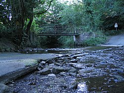
Ffrith is a small village in the community of Llanfynydd in Flintshire, north-east Wales.

Cymau is a small village situated in the community of Llanfynydd, Flintshire on the edge of the mountains of north-east Wales. Its name is the Welsh word cymau, a plural of cwm, "valley".

Cefn-y-bedd is a village in Flintshire, north-east Wales.

The River Terrig is a small river in north-east Wales.
The River Gwenfro is a small river in Wrexham County Borough, north Wales. It is a tributary of the Clywedog. The name Gwenfro is possibly derived from the Welsh language words gwen, "white", and bro, "border", "boundary".

Llanfynydd is a village, local government community and electoral ward in Flintshire, Wales. Its name is derived from the Welsh words llan, and mynydd ("mountain").

Rhydtalog is a small, isolated village in Flintshire, Wales. It lies in hilly country on the border with Denbighshire in the community of Treuddyn.

Nant-y-Ffrith refers to a stream and the wooded valley through which it flows on the border between Flintshire and Wrexham County Borough in Wales. The stream begins in moorland to the east of Llandegla. It passes Bwlchgwyn village before entering a rather steep-sided, rocky valley. It passes under the viaduct of a disused railway line before joining the River Cegidog at Ffrith.

Ffrith railway station was a station in Ffrith, Flintshire, Wales. The station was opened on 2 May 1898 and closed on 27 March 1950.
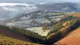
The Clwydian Range and Dee Valley is a designated Area of Outstanding Natural Beauty (AONB) located in north-east Wales, covering the Clwydian Range, and the valley of the River Dee.