Whitewell, Wrexham

Last updated

Whitewell
St Mary's church, Whitewell geograph-4893183-by-Gareth-James.jpg
St Mary's church, Whitewell
Wrexham UK location map.svg
Red pog.svg
Whitewell
Location within Wrexham
OS grid reference SJ4949641397
Community
Principal area
Ceremonial county
Country Wales
Sovereign state United Kingdom
Post town WHITCHURCH
Postcode district SY13
Dialling code 01948
Police North Wales
Fire North Wales
Ambulance Welsh
UK Parliament
Senedd Cymru – Welsh Parliament
List of places
UK
Wales
Wrexham
52°58′01″N2°45′11″W / 52.967°N 2.753°W / 52.967; -2.753 Coordinates: 52°58′01″N2°45′11″W / 52.967°N 2.753°W / 52.967; -2.753

Whitewell ( Loudspeaker.svg Welsh pronunciation ) is a dispersed rural settlement, and surrounding ecclesiastical parish, in the community of Bronington, in the east of Wrexham County Borough, Wales.

Contents

The Welsh language name of the parish, and of the area's former civil parish, is Iscoed, historically spelled as Iscoyd. [1] The name can be translated as "below wood" or "underwood". [2]

History

Recorded as early as 1570, the chapel at Whitewell was originally a chapel of ease to Malpas in Cheshire, although geographically it lay in the detached portion of Flintshire known as the Maelor Saesneg. [1] A 1657 visitation referred to it as the "Chappell of Whitewell" and suggested it be made a separate parish church, given its distance from Malpas and two fords across the " river of Elfe [and] another dangerous brooke". [3] At this time the township of Malpas parish in which the chapel lay was usually known as Iscoyd.

The Iscoyd Brook, near Whitewell. It flows into the Wych Brook (formerly the River Elfe), which forms the northern parish boundary. Iscoyd Brook - geograph.org.uk - 336595.jpg
The Iscoyd Brook, near Whitewell. It flows into the Wych Brook (formerly the River Elfe), which forms the northern parish boundary.

Whitewell was finally made a parish in its own right in 1885, at which time its parishioners elected to stay part of the Diocese of Chester. [1] The boundaries of the new parish of Whitewell were identical to those of Iscoyd township. [4] While the parish remained part of the Church of England, for civil administration purposes the area (known as the civil parish of Iscoyd) remained in Wales as part of the Maelor Rural District of Flintshire, although an 1887 Boundary Commission review found that a majority of the local population favoured becoming part of Shropshire. [5] In 1974, under the terms of the Local Government Act 1972, it was merged into the community of Bronington as part of the new county of Clwyd. It subsequently became part of Wrexham County Borough.

There were once two saline springs at the hamlet of Lower Wych in the parish, with a further three springs nearby at Higher Wych on the English side of the border. [6] These natural springs or 'brine pits' were used to extract water for salt production by evaporation in 'wych-houses'. Salt was recorded as being produced here from the 14th century up until as late as 1845. [7] One brine pit, measuring about 7 metres across, [8] shown on early Ordnance Survey maps as a 'salt spring', still exists on the southern bank of the Wych Brook at Lower Wych immediately after the Shothill Brook joins it.

The presence of the salt springs has led to Iscoyd township, along with neighbouring township of Tybroughton, being identified with the lost Domesday Book manor of Burwardeston, which was described as containing a salt house. [9]

St Mary’s church

The isolated parish church is situated in a rectilinear churchyard alongside the Iscoyd Brook. It is a whitewashed brick building constructed in 1830, with a spire and clock added in 1898. [1] It replaced an earlier thatched, timber-framed building that collapsed in 1829 during an attempt to restore it. [1] [4] The church contains some panelling reused from the earlier building, as well as a 1696 monument to the clergyman and diarist Philip Henry, who lived nearby, [4] and a memorial dated 1782 to local landowner Richard Congreve, who was the first burial in the church grounds. [10]

The rector between 1885 and 1926 was the Rev. Joseph Jacob, an amateur botanist and author. [11] Jacob, an editor of the Royal Horticultural Society Daffodil Yearbook, was responsible for the large-scale planting of daffodils which still grow in the churchyard, and developed cultivars of daffodil, crocus and Lachenalia named after Whitewell.

The White Well, the well or spring from which the settlement takes its name, possibly a holy well associated with the church site, is located south of the churchyard. [4] Writing in 1876, the Vicar of Hanmer Canon M.H. Lee noted that the Domesday Book recorded many church land holdings in the area, suggested a link with the monastery at Bangor-on-Dee and speculated that the pre-1829 chapel had been Anglo-Saxon in origin. [12] While there is some indication of a place of worship being on the site from very early times, [1] and it has been suggested that the well marks the site of the original chapel, [13] the current assessment of the Clwyd-Powys Archaeological Trust is that there is no firm evidence that the well has special religious significance. [10] A second well is located some 40 metres south-west of the White Well. [10]

Historic buildings

Although most buildings within Whitewell itself are of 19th century origin, there is a grade II listed thatched carriage shelter, probably dating from the 17th or 18th century, close to the church. [10] Also within the parish is the mansion of Iscoyd Park, a grade II* listed 18th century house. There is a listed war memorial near to Iscoyd Park. [14]

Whitewell Parish Hall is grade II listed and along with the rectory is in the style of John Douglas, although not previously attributed to him. [15]

Related Research Articles

<span class="mw-page-title-main">Flintshire</span> County in Wales

Flintshire is a county in the north-east of Wales. It borders England to the east, Denbighshire to the west and Wrexham County Borough to the south. It is named after the historic county of the same name which has notably different borders. Flintshire is considered part of the Welsh Marches and formed part of the historic Earldom of Chester and Flint. The county is governed by Flintshire County Council which has its main offices in County Hall, Mold.

<span class="mw-page-title-main">Flintshire (historic)</span> Historic county of Wales

Flintshire, also known as the County of Flint, is one of Wales' thirteen historic counties, and a former administrative county. It mostly lies on the north-east coast of Wales.

<span class="mw-page-title-main">Bangor-on-Dee</span> Village in Wales

Bangor-on-Dee is a village and community in Wrexham County Borough, Wales, on the banks of the River Dee. Until 1974 it was in the exclave of Flintshire known as the Maelor Saesneg, and from 1974 to 1996 in the county of Clwyd.

The Maelor is an area of north-east Wales along the border with England. It is now entirely part of Wrexham County Borough.

<span class="mw-page-title-main">English Maelor</span> Area of Wrexham County Borough, east of the River Dee

English Maelor comprises one half of the Maelor region on the Welsh side of the Wales-England border, being the area of the Maelor east of the River Dee. The region has changed counties several times, previously being part of Cheshire and later a detached portion of Flintshire. The area is currently in Wales, despite its name, and administered as part of Wrexham County Borough.

<span class="mw-page-title-main">Wrexham County Borough</span> County borough in Wales

Wrexham County Borough is a county borough, with city status, in the north-east of Wales. It borders England to the east and south-east, Powys to the south-west, Denbighshire to the west and Flintshire to the north-west. The county borough has a population of 136,055. The city of Wrexham is its largest settlement, which together with villages such as Gwersyllt, New Broughton, Bradley and Rhostyllen form a built-up area with 65,692 residents. Villages in the county borough also include Ruabon, Rhosllanerchrugog, Johnstown, Acrefair, Bangor-on-Dee, and Coedpoeth amongst others. The county borough has two outlying towns, Chirk and Holt, and various rural settlements in the county borough's large salient in the Ceiriog Valley, and the English Maelor.

<span class="mw-page-title-main">Overton-on-Dee</span> Village in Wales

Overton or Overton-on-Dee is a village and community in Wrexham County Borough, Wales. It is situated close to the Welsh-English border on the edge of an escarpment that winds its way around the course of the River Dee, from which Overton-on-Dee derives its name.

<span class="mw-page-title-main">St Giles' Church, Wrexham</span> Church in Wrexham County Borough, Wales

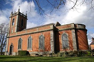
St Giles' Parish Church is the parish church of Wrexham, Wales. The church is recognised as one of the finest examples of ecclesiastical architecture in Wales and is a Grade I listed building, described by Sir Simon Jenkins as 'the glory of the Marches' and by W. D. Caröe as a “glorious masterpiece.”

Maelor was a rural district in the administrative county of Flintshire, Wales, from 1894 to 1974. The area approximated to the hundred of Maelor or English Maelor, and was notable for forming a detached part of the county, surrounded by Cheshire, Denbighshire and Shropshire. The administrative centre was located at Overton.

<span class="mw-page-title-main">Marford</span> Village in Wrexham County Borough, Wales

Marford is a village in Wrexham County Borough, Wales, near the Wales-England border.

<span class="mw-page-title-main">Erbistock</span> Village in Wales

Erbistock is a village and community in Wrexham County Borough, Wales. The village lies on the banks of the River Dee.

<span class="mw-page-title-main">Gwersyllt</span> Village in Wales

Gwersyllt is an urban village and community in Wrexham County Borough, Wales.

<span class="mw-page-title-main">Penley</span> Village in Wales

Penley is a village in the County Borough of Wrexham, in Wales close to the border with Shropshire, England, and had a population of 606 as of the 2011 census.

<span class="mw-page-title-main">Philip Henry</span>

Philip Henry was an English Nonconformist clergyman and diarist. His son Matthew Henry was a notable commentator on the Bible and also a Presbyterian minister.

<span class="mw-page-title-main">Bronington</span> Village in Wales

Bronington is a village and community in Wrexham County Borough, Wales, forming a large part of the Maelor Saesneg. Within the boundaries of the historic county of Flintshire, the community has an area of 3,482 hectares and a population of 1,228, increasing to 1,242 at the 2011 Census.

<span class="mw-page-title-main">Willington Worthenbury</span> Community in Wrexham County Borough, Wales

Willington Worthenbury is a community in Wrexham County Borough, Wales, and is situated near the England–Wales border.

<span class="mw-page-title-main">Oldcastle, Cheshire</span> Human settlement in England

Oldcastle is a former civil parish, now in the parishes of Malpas and Threapwood, in the Cheshire West and Chester district and ceremonial county of Cheshire in England. In 2001 it had a population of 54. The civil parish was abolished in 2015 and merged into Malpas and Threapwood.

<span class="mw-page-title-main">Wych Brook</span> River in Wales and England

The Wych Brook, Worthenbury Brook and Red Brook, formerly known as the River Elfe, is a tributary of the River Dee in England and Wales, forming part of both the historic and present-day border between the two countries. The stream forms part of the border between Cheshire and Shropshire in England to the east, and Wales, particularly the Maelor Saesneg, to the west.

Tybroughton, occasionally written Ty Broughton, is the name of a former civil parish, historically in the Maelor Saesneg area of Flintshire, Wales and now in Wrexham County Borough. The rather isolated rural area contains no nucleated villages, although there are a few small hamlets such as Eglwys Cross.

<span class="mw-page-title-main">Halghton</span> Human settlement in Wales

Halghton is a dispersed settlement and former civil parish in the east of Wrexham County Borough, Wales. It is part of the community of Hanmer.

References

  1. 1 2 3 4 5 6 Iscoyd / Whitewell, Clwyd Family History Society
  2. Davies, Flintshire Place-names, 1959, p.90
  3. Lee, "Iscoyd in Maelor Saesneg], Archaeologia Cambrensis, XXVI, April 1876, p.87
  4. 1 2 3 4 ’’An Inventory of the Ancient Monuments in Wales and Monmouthshire, II: County of Flint’’, 1911, p.110-1
  5. Flintshire Quarter Sessions, Liverpool Mercury, February 8, 1888
  6. Lee, 1876, p.92
  7. Bagshaw, History, Gazetteer, and Directory of Shropshire, 1850, p.149
  8. Maelor Saesneg, Industrial Landscapes, CPAT
  9. Dodgson, The Place-names of Cheshire, Part IV, 1972, p.1, p.52
  10. 1 2 3 4 Whitewell, 2013, CPAT
  11. Desmond, Dictionary Of British And Irish Botanists And Horticulturists, 1994, p.378
  12. Lee, "Iscoyd in Maelor Saesneg], Archaeologia Cambrensis, XXVI, April 1876, p.84
  13. Church of St Mary, Whitewell, Wrexham Churches Survey, CPAT
  14. Iscoyd / Whitewell war memorial, Clwyd Family History Society
  15. Whitewell Parish Hall, British Listed Buildings