Bangor Bridge

Last updated

Bangor Bridge

Pont Bangor (Welsh)
Pont Bangor-is-y-Coed - Grade I Listed Building in Bangor-on-Dee, Wrexham, Wales 12.jpg
The bridge from the south.
Coordinates 53°00′10″N2°54′49″W / 53.0028°N 2.91365°W / 53.0028; -2.91365
Crosses River Dee
Locale Bangor-on-Dee and Sesswick, Wrexham, Wales
Other name(s)Bangor-on-Dee Bridge
Bangor-is-y-Coed Bridge
Pont Bangor-is-y-Coed
Bangor Old Bridge
Heritage status Grade I
Characteristics
Design Arch bridge
MaterialMainly red sandstone
Width11 feet (3.4 m)
No. of lanes one (one-way traffic)
History
Architect Inigo Jones (speculated; 1658 rebuilding)
Construction startMedieval origins
Rebuilt1658
Statistics
Listed Building – Grade I
Official nameBangor Bridge (Partly in Sesswick community) and Bangor Bridge (Partly in Bangor-is-y-Coed Community)
Designated16 November 1962
Amended 24 February 1997 and 20 December 1996
Reference no.1645 [1] and 1635 [2] (dual-listed)
Official nameBangor Bridge
Reference no.3781 [3]
Location
Bangor Bridge

Bangor Bridge (also known as the Bangor-on-Dee Bridge) is a Grade I listed bridge crossing the River Dee in Bangor-on-Dee, Wrexham County Borough, Wales. It is situated on the community boundary between Bangor-is-y-Coed and Sesswick. Located to the west of Bangor-on-Dee, it connects the village's high street and the A525 road bypass. The narrow bridge is a one-way traffic bridge, west to east, and is downstream (north) of the Bangor by-pass bridge.

Contents

Description

The bridge crosses the River Dee, with the river currently serving as the boundary between the communities of Bangor-is-y-Coed and Sesswick within Wrexham County Borough since 1996. [1] [2] [4] [5] The River Dee at this location, historically served as the boundary between the historic county of Denbighshire to the west and Flintshire's Maelor Saesneg containing Bangor-on-Dee to the east.

The bridge is listed by Cadw, and described to have a group value with the nearby listed buildings of Bangor-on-Dee war memorial and the Church of St Dunawd. [1] [2]

The cambered bridge's five unequal elliptical stepped arches are mainly made of red sandstone, with some coursed rubble and finely dressed stone. The bridge has four buttresses. The parapets and full height splayed cutwaters are made of yellow sandstone with refuges on the top. The parapets are also made of large dressed slabs and are 11 feet (3.4 m) apart. [1] [4] [6] [7] [8] [9]

Inigo Jones is speculated to be the bridge's architect, with similar bridges constructed in places such as Llanrwst (Pont Fawr) and Llangollen attributed to him. [6]

A scheduled monument is also on the site, consisting of a medieval or post-medieval remains of an older bridge. [3]

History

The earliest reports of a bridge at or near this location in historical maps date to 1036, whereas the earliest mention of a medieval wooden design bridge at this location was recorded in 1292. [10]

The current bridge is of medieval late 15th or early 16th century origins [7] [8] [9] but the current structure mainly dates to the 17th century, with a notable restoration in 1658, by Inigo Jones. [1] [2] [7] [9]

The bridge was repaired several times over its lifespan, including a £23. 16s. repair (equivalent to £3,263in 2020) in 1757 caused by frequent flooding. There was another repair costing £109. 3s. 10d. (equivalent to £10,959in 2020) in 1843. [6] Although, described to be "in a state of deterioration", while still used. [9]

It was recorded by the Royal Commission on the Ancient and Historical Monuments of Wales in 1910. [6] The bridge connects to the village's high street. [1] [2]

Prior to the 1900's the bridge was mainly used by horse-drawn vehicles, farm carts and pedestrians. When motor vehicle usage on the bridge increased, it damaged the bridge, leading to the introduction of traffic lights and weight restrictions on the bridge to limit the damage. In 1970, there was a petition to construct a new bridge and by-pass in the village, with the bridge and by-pass completed in 1978 and is located south (upstream) of the medieval bridge. The Bangor-on-Dee bridge was reduced to only one-way traffic from the west, when the A525 by-pass opened. [6] One of the bridge's parapets were destroyed by a tractor in 1996, with repairs later carried out, as well as a wider restoration works since the 1990s. [9]

See also

Related Research Articles

<span class="mw-page-title-main">Bangor-on-Dee</span> Village in Wales

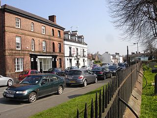
Bangor-on-Dee is a village and community in Wrexham County Borough, Wales, on the banks of the River Dee. Until 1974 it was in the exclave of Flintshire known as the Maelor Saesneg, and from 1974 to 1996 in the county of Clwyd.

<span class="mw-page-title-main">Betws-y-Coed</span> Village and community in Conwy, Wales

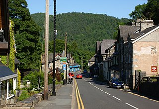
Betws-y-coed is a village and community in the Conwy valley in Conwy County Borough, Wales, located in the historic county of Caernarfonshire, right on the boundary with Denbighshire, in the Gwydir Forest. It is now a very popular visitor destination in the Snowdonia National Park.

<span class="mw-page-title-main">River Taff</span> River in Wales which flows into Cardiff Bay

The River Taff is a river in Wales. It rises as two rivers in the Brecon Beacons; the Taf Fechan and the Taf Fawr before becoming one just north of Merthyr Tydfil. Its confluence with the River Severn estuary is in Cardiff.

<span class="mw-page-title-main">Raglan, Monmouthshire</span> Village in Monmouthshire, Wales

Raglan (; is a village and community in Monmouthshire, south east Wales, United Kingdom. It is located some 9 miles south-west of Monmouth, midway between Monmouth and Abergavenny on the A40 road very near to the junction with the A449 road. The fame of the village derives from Raglan Castle, built for William ap Thomas and now maintained by Cadw. The community includes the villages of Llandenny and Pen-y-clawdd. Raglan itself has a population of 1,183.

<span class="mw-page-title-main">Rossett</span> Village in Wrexham County Borough, Wales

Rossett is a village, community and electoral ward in Wrexham County Borough, Wales. Rossett is served by the A483 road.

<span class="mw-page-title-main">Farndon Bridge</span> Bridge between England and Wales

Farndon Bridge, also known as Holt Bridge, crosses the River Dee and the England-Wales border between the villages of Farndon, Cheshire, England and Holt, Wrexham, Wales. The bridge, which was built in the mid-14th century, is recorded in the National Heritage List for England and by Cadw as a designated Grade I listed building and scheduled monument. It is built from locally quarried red sandstone and had eight arches, of which five are over the river. On the Farndon side there is one flood arch and two flood arches are on the Holt side.

<span class="mw-page-title-main">St Dunawd's Church</span> Church in Wrexham County Borough, Wales

St Dunawd's Church, is in the village of Bangor-on-Dee, Wrexham County Borough, Wales. It is designated by Cadw as a Grade II* listed building. The church is an active Anglican church in the deanery of Dee Valley, the archdeaconry of Wrexham and the diocese of St Asaph.

<span class="mw-page-title-main">Sesswick</span> Community in Wrexham County Borough, Wales

Sesswick is a community in Wrexham County Borough, Wales. It lies south-east of Wrexham near Marchwiel. The population of the community at the 2011 Census was 609.

<span class="mw-page-title-main">Cefn-coed-y-cymmer</span> Historic site

Cefn-coed-y-cymmer is a small community on the northwestern edge of Merthyr Tydfil County Borough in Wales. It is situated in the neck of land between the rivers Taf Fawr and Taf Fechan at their confluence. The village lies within the community of Vaynor. Immediately to the north of the village is the hill of Cefn Cil Sanws on the southern slopes of which is Merthyr Tydfil Golf Club. The village is bounded both to the north and the west by the Brecon Beacons National Park.

<span class="mw-page-title-main">St Mary's Church, Betws-y-Coed</span> Church in Conwy, Wales

St Mary's Church, Betws-y-Coed, is in the village of Betws-y-Coed, Conwy, Wales. It is an active Anglican parish church of the Church in Wales, in the deanery of Arllechwedd, the archdeaconry of Bangor and the diocese of Bangor. The church is designated by Cadw as a Grade II* listed building.

<span class="mw-page-title-main">Grade I listed buildings in Wrexham County Borough</span>

In the United Kingdom, the term listed building refers to a building or other structure officially designated as being of special architectural, historical, or cultural significance; Grade I structures are those considered to be "buildings of exceptional interest". Listing was begun by a provision in the Town and Country Planning Act 1947. Once listed, strict limitations are imposed on the modifications allowed to a building's structure or fittings. In Wales, the authority for listing under the Planning Act 1990 rests with Cadw.

<span class="mw-page-title-main">Grade II* listed buildings in Neath Port Talbot</span>

In the United Kingdom, the term listed building refers to a building or other structure officially designated as being of special architectural, historical, or cultural significance; Grade II* structures are those considered to be "particularly important buildings of more than special interest". Listing was begun by a provision in the Town and Country Planning Act 1947. Once listed, strict limitations are imposed on the modifications allowed to a building's structure or fittings. In Wales, the authority for listing under the Planning Act 1990 rests with Cadw.

<span class="mw-page-title-main">Melin-y-Coed</span> Human settlement in Wales

Melin-y-Coed is a small rural village in the county of Conwy, Wales.. The earliest surviving building in the village is Cyffdy Hall, built in 1596.

St Deiniols Ash is a 16th or 17th century Grade I listed timber framed manor house located next to the church of St Deiniol in Hawarden, in Flintshire, north-east Wales. The house contains a series of wall paintings depicting the life of St Deiniol which are considered among the best preserved examples in Britain.

<span class="mw-page-title-main">Cefn Viaduct, Wrexham</span> Railway viaduct in Wrexham County Borough, Wales

The Cefn (Newbridge) Viaduct is Grade II* listed railway viaduct across the River Dee between Cefn and Chirk communities in Wrexham County Borough, Wales. The viaduct is near the villages of Cefn Mawr, Pentre and Newbridge. The viaduct forms the eastern boundary of Tŷ Mawr Country Park and is around a mile downstream of Pontcysyllte Aqueduct.

<span class="mw-page-title-main">Chirk Viaduct</span> Railway viaduct between England and Wales

The Chirk Viaduct is a Grade II* listed railway viaduct over the River Ceiriog between England and Wales. The viaduct carries the Shrewsbury–Chester line from the Welsh town of Chirk in historic Denbighshire from the north to the English village of Chirk Bank in Weston Rhyn, Shropshire to the south. Chirk Aqueduct lies parallel to the viaduct's east.

<span class="mw-page-title-main">Cook's Bridge, Rossett</span> Bridge in Wrexham, Wales

Cook's Bridge is a Grade II listed bridge crossing the River Alyn near Trevalyn, Rossett in Wrexham County Borough, Wales. It is located to the south-east of Cooksbridge Farm, and roughly a third of a mile or half a kilometre from Rossett Road (B5102).

<span class="mw-page-title-main">Newbridge, Wrexham</span> Village in Wrexham County Borough, Wales

Newbridge is a village in Wrexham County Borough, Wales. The village is within the community of Cefn, to the south-east of Cefn Mawr. Newbridge is bounded to the west by the Shrewsbury–Chester railway line and the Newbridge Railway Viaduct which crosses the River Dee, which meanders to the south and east of the village. The Clwydian Range and Dee Valley AONB since 2011 borders the village to the south, as does the Wynnstay estate, and Tŷ Mawr Country Park is on the other side of the viaduct to the west.

References

  1. 1 2 3 4 5 6 Cadw. "Bangor Bridge (Partly in the Sesswick community) (Grade I) (1645)". National Historic Assets of Wales . Retrieved 13 June 2022.
  2. 1 2 3 4 5 Cadw. "Bangor Bridge (Partly in Bangor-is-y-Coed Community) (Grade I) (1635)". National Historic Assets of Wales . Retrieved 13 June 2022.
  3. 1 2 Cadw. "Bangor Bridge (FL017)". National Historic Assets of Wales . Retrieved 13 June 2022. Archived 13 June 2022 at the Wayback Machine . Retrieved 13 June 2022.
  4. 1 2 "Bangor Bridge (Partly in the Sesswick community), Bangor-on-Dee, Wrexham". britishlistedbuildings.co.uk. Archived from the original on 19 September 2019. Retrieved 13 June 2022.
  5. "Bangor Bridge (Partly in Bangor-is-y-Coed Community), Bangor-on-Dee, Wrexham". britishlistedbuildings.co.uk. Archived from the original on 7 April 2019. Retrieved 13 June 2022.
  6. 1 2 3 4 5 "Bangor-on-Dee Bridge - Bangor Isycoed Bridge - North Wales". www.bangor-on-dee.co.uk. Archived from the original on 17 December 2021. Retrieved 13 June 2022.
  7. 1 2 3 "Bangor Bridge, Bangor-Is-y-Coed (24030)". Coflein. RCAHMW . Retrieved 13 June 2022.
  8. 1 2 "BRIDGE, BANGOR-ON-DEE (Hansard, 17 March 1964)". api.parliament.uk. Archived from the original on 13 June 2022. Retrieved 13 June 2022.
  9. 1 2 3 4 5 "Bangor Is-y-Coed Bridge". archaeologydataservice.ac.uk. Archaeology Data Service - Clwyd-Powys Archaeological Trust . Retrieved 12 April 2023.
  10. Roberts, Craig (19 December 2018). "5 interesting things about Bangor-on-Dee - news.wrexham.gov.uk". Archived from the original on 17 June 2021. Retrieved 13 June 2022.