
Gower or the Gower Peninsula in southwest Wales, projects towards the Bristol Channel. It is the most westerly part of the historic county of Glamorgan. In 1956, the majority of Gower became the first area in the United Kingdom to be designated an Area of Outstanding Natural Beauty.

Cyncoed ; is an affluent and exclusive community in the northeast of Cardiff, the capital of Wales. With many properties in the area fetching over £1 million, Cyncoed is considered to have some of the highest property prices in the country. Cyncoed overlooks the city centre of Cardiff, near Roath Park, with views of the surrounding mountains.

Caergwrle is a village in the county of Flintshire, in north east Wales. Approximately 5–6 miles (8.0–9.7 km) from Wrexham and situated on the A541 road, it is contiguous with the villages of Abermorddu and Hope, though in parts Caergwrle and Hope are separated by a river border. The village lies on the River Alyn and sits at the base of Hope Mountain. At the 2001 Census, the population was 1,650. The population was subsequently absorbed in the community of Hope and only the electoral ward remained. The population of this ward as taken at the 2011 census was 1,619. The ward includes the area of Abermorddu. Further south is the village of Cefn-y-Bedd.

Ewloe is a village in Flintshire, Wales, contiguous with Hawarden and Buckley and near to Queensferry and Shotton. Situated close to the Flintshire/Cheshire sector of the Wales-England border, Ewloe forms part of Deeside. The A55 expressway passes through the town and its most notable landmark is Ewloe Castle. At the 2001 Census, the population was 4,862. Ewloe ceased being a town in its own name with all of the population being listed under Hawarden. The electoral ward remained with a total population taken at the 2011 Census of 5,420.

Deeside is the name given to a predominantly industrial conurbation of towns and villages in Flintshire and Cheshire on the Wales–England border lying near the canalised stretch of the River Dee that flows from neighbouring Chester into the Dee Estuary. These include Connah's Quay, Shotton, Queensferry, Aston, Garden City, Sealand, Broughton, Bretton, Hawarden, Ewloe, Mancot, Pentre, Saltney and Sandycroft. The population is around 50,000, with a plurality (17,500) living in Connah's Quay.

Broughton is a large village in Flintshire, Wales, close to the Wales–England border, located to the west of the city of Chester, England, in the community of Broughton and Bretton. Along with the nearby village of Bretton, the total population was 5,791 at the 2001 Census, increasing to 5,974 at the 2011 Census.
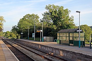
Hope railway station serves the village of Hope in Flintshire, Wales. The station is 5+1⁄4 miles (8.4 km) north of Wrexham Central on the Borderlands Line. The name of the station in Welsh is Yr Hob.

Hope is a small village and community in Flintshire, north-east Wales. The village is located approximately 3 miles / 4.5 km from the Wales-England border, on the course of the River Alyn, and less than 5 miles from Wrexham.

Treuddyn is a village, community and electoral ward in Flintshire, Wales, located just off the A5104 road, around 4 miles south-east of Mold and 3 miles north-west of Caergwrle. The community includes the nearby village of Coed Talon, to the east, and Rhydtalog, to the south-west on the Denbighshire border. The community's population was 1,627 during the 2011 Census.

Nannerch is a village and community in Flintshire, Wales, located within the Clwydian Range and Dee Valley Area of Outstanding Natural Beauty. At the 2001 Census the population of Nannerch was 531, reducing to 233 at the 2011 Census. The community population in 2011 was 496.

The village of Parkmill is a small rural settlement in the Gower Peninsula, South Wales, midway between the villages of Penmaen and Ilston, about eight miles (13 km) west of Swansea, and about one mile (1.5 km) from the north coast of the Bristol Channel. The village lies to the north of the A4118, the main South Gower road between Swansea and Port Eynon, in a wooded area, at the bottom of a valley.

Greenfield is a village in the community of Holywell, Flintshire, north-east Wales, on the edge of the River Dee estuary. At the time of the 2001 census it had a population of 2,741, which remained unchanged in the 2011 census.

Caergwrle Castle, also known as Queen's Hope in scholarly texts, is located in the town of Caergwrle, in Flintshire, Wales. It was built by the Welsh under Dafydd ap Gruffydd in service to Edward I of England. When Dafydd's forces rebelled against the English, Edward sent Reginald de Grey, 1st Baron Grey de Wilton to take the castle in June 1282, but Dafydd had retreated and sabotaged the structure. Rebuilding works began, and it was given to Edward's wife, Eleanor of Castile. A town was planned at the base of the castle, but this was abandoned after a fire broke out in September 1283 when both Edward and Eleanor were present. It was passed down the royal line, but was never rebuilt. In 1823, a workman discovered the Caergwrle Bowl near the castle; it is a unique Bronze Age bowl.

Cefn-y-bedd is a village in Flintshire, north-east Wales.

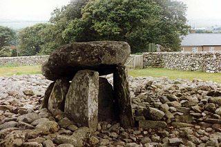
The St Lythans burial chamber is a single stone megalithic dolmen, built around 4,000 BC as part of a chambered long barrow, during the mid Neolithic period, in what is now known as the Vale of Glamorgan, Wales.
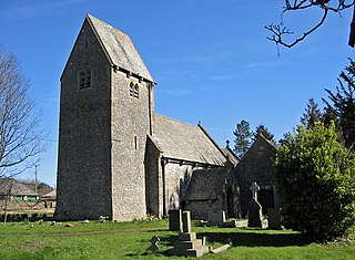
St Lythans is an affluent hamlet and former parish in the Vale of Glamorgan, southeast Wales, just outside western Cardiff. It lies southwest of Culverhouse Cross, west of Wenvoe and southwest of Twyn-yr-Odyn and is also connected by road from Dyffryn and the Five Mile Lane in the west. It is one of the wealthiest communities in the Vale of Glamorgan, containing some notable mansions and cottages, valued on average at over £500,000 as of 2011. The megalithic St Lythans burial chamber, over 6000 years old, lies 1 km to the west of the village and the hamlet also contains the St.Lythans Parish Church or Church of St Bleddian, a Grade II* listed building.

Parc Cwm long cairn, also known as Parc le Breos burial chamber, is a partly restored Neolithic chambered tomb, identified in 1937 as a Severn-Cotswold type of chambered long barrow. The cromlech, a megalithic burial chamber, was built around 5850 years before present (BP), during the early Neolithic. It is about seven 1⁄2 miles (12 km) west south–west of Swansea, Wales, in what is now known as Coed y Parc Cwm at Parc le Breos, on the Gower Peninsula.

Parc le Breos was a great medieval deer park in the south of the Gower Peninsula, about eight miles (13 km) west of Swansea, Wales, and about 1+1⁄4 miles (2.0 km) north of the Bristol Channel. The park was an enclosed, oval area of 6.7 miles (10.8 km) in circumference, covering about 2,000 acres (810 ha) and measuring 2+1⁄2 miles (east–west) by just over 1+3⁄4 miles. Parc le Breos was established in the 1220s CE by John de Braose, Marcher Lord of Gower and husband to Margaret Ferch Llywelyn, Llywelyn Fawr's daughter. Other than for deer husbandry, the park received an income from agistment, pannage, and from sales of wild honey, ferns and dead wood. There is evidence of rabbit warrens in the park. Whether the warrens were free or domestic is unknown.
Dyffryn Ardudwy is a village, community and electoral ward in the Ardudwy area of Gwynedd, Wales consisting of several small, almost conjoined, villages including Coed Ystumgwern, Llanenddwyn, Llanddwywe, Talybont and Dyffryn Ardudwy. It is situated on the main A496 coast road between Harlech and Barmouth. The ward had a population of 1,540 according to the 2011 census.

The coal industry in Wales has played an important role in the Industrial Revolution. Coal mining in Wales expanded in the eighteenth century to provide fuel for the blast furnaces of the iron and copper industries that were expanding in southern Wales. The industry had reached large proportions by the end of that century, and then further expanded to supply steam-coal for the steam vessels that were beginning to trade around the world. The Cardiff Coal Exchange set the world price for steam-coal and Cardiff became a major coal-exporting port. The South Wales Coalfield was at its peak in 1913 and was one of the largest coalfields in the world. It remained the largest coalfield in Britain until 1925. The supply of coal dwindled, and pits closed in spite of a UK-wide strike against closures. The last deep mine in Wales, Tower Colliery, closed in 2008, after thirteen years as a co-operative owned by its miners.


