
Hawarden is a village, community and electoral ward in Flintshire, Wales. It is part of the Deeside conurbation on the Wales-England border and is home to Hawarden Castle. In the 2011 census the ward of the same name had a population of 1,887, whereas the community of the same name, which also includes Ewloe Mancot and Aston had a population of 13,920. The scenic wooded Hawarden Park abuts the clustered settlement in the south. Hawarden Bridge consists of distribution and industrial business premises beyond Shotton/Queensferry and the Dee. The west of the main street is called The Highway, its start marked by the crossroads with a fountain in the middle, near which are public houses, some with restaurants.

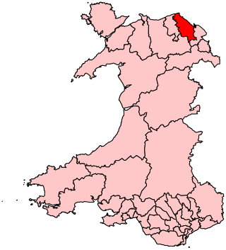
Mostyn is a village and community in Flintshire, Wales, and electoral ward lying on the estuary of the River Dee, located near the town of Holywell. It has a privately owned port that has in the past had a colliery and ironworks and was involved in the export of commodities, and in present times services the offshore wind industry and ships the wings for the Airbus A380 which are manufactured at Broughton.

Ewloe is a village and electoral ward in the community of Hawarden in Flintshire, Wales. It is situated close to the Flintshire/Cheshire sector of the Wales-England border. The A55 expressway passes through Ewloe and its most notable landmark is Ewloe Castle. The Ewloe electoral ward had a population at the 2011 Census of 5,420. The urban area of the village is contiguous with Hawarden, Buckley and Shotton. The Office for National Statistics deems Ewloe to form part of the Buckley built-up area, which covers much of Deeside.
Delyn is a constituency represented in the House of Commons of the UK Parliament since 2019 by Rob Roberts, who was elected as a Conservative, but currently sits as an Independent following sexual harassment allegations.

Mynydd Isa is a village in Flintshire, in north-east Wales. It lies between the county town of Mold, and Buckley in the community of Argoed which had a population of 5837 according to the 2011 census. Mynydd Isa was originally a small hamlet on the north side of the Mold to Buckley road just downhill from the now demolished Calvinist chapel. It did not appear on Ordnance Survey maps until 1912.

Sealand is a community in Flintshire and electoral ward, north-east Wales, on the edge of the Wirral peninsula. It is west of the city of Chester, England, and is part of the Deeside conurbation on the Wales-England border. At the 2001 Census, it had a population of 2,746, increasing to 2,996 at the 2011 census. The community includes the villages of Garden City and Sealand, and the settlements of Higher Ferry, Sealand Manor and Sealand Road.
Bagillt is a market town and community in Flintshire, Wales. The town overlooks the Dee Estuary and is between the towns of Holywell and Flint. At the 2001 Census the population was recorded as 3,918, increasing to 4,165 at the 2011 census. The community also includes the villages of Walwen and Whelston. Landmark locations such as Gemma Rushes bath.

Higher Kinnerton is a village and community within rural Flintshire, Wales, close to the Wales-England border. Its sister village, Lower Kinnerton, is across the border in Cheshire, England.

Hope is a small village and community in Flintshire, north-east Wales. The village is located approximately 3 miles / 4.5 km from the Wales-England border, on the course of the River Alyn, and less than 5 miles from Wrexham.

Treuddyn is a village, community and electoral ward in Flintshire, Wales, located just off the A5104 road, around 4 miles south-east of Mold and 3 miles north-west of Caergwrle. The community includes the nearby village of Coed Talon, to the east, and Rhydtalog, to the south-west on the Denbighshire border.
Halkyn is a village and community in Flintshire, north-east Wales and situated between Pentre Halkyn, Northop and Rhosesmor. At the 2001 Census the population of the community was 2,876, increasing slightly to 2,879 at the 2011 Census. Pentre Halkyn is in the community.
Llangors is a small village, community and electoral ward in southern Powys, in the historic county of Brecknockshire, within the Brecon Beacons National Park.
Mynydd Isa Football Club were a Welsh football team who played in the Cymru Alliance until the end of the 2008–09 season. They played their games at Argoed Sports Ground in Mynydd Isa, near Mold, Flintshire, Wales.
Whitford is a village, community and an electoral ward near Holywell in Flintshire, northeast Wales. The population of both the community and the ward taken at the 2011 census was 2,332. The community includes the villages of Carmel, Lloc, Gorsedd and Pantasaph.

Llangattock is a village, community and electoral ward in the Brecon Beacons National Park in Powys, Wales. It lies in the Usk Valley just across the river from the town of Crickhowell. The Monmouthshire and Brecon Canal passes through the village en route between Brecon and Pontypool. It is in the historic county of Breconshire.

Llanfynydd is a village, local government community and electoral ward in Flintshire, Wales. Its name is derived from the Welsh words llan, and mynydd ("mountain").

New Brighton is a small village in Flintshire, in north-east Wales. It lies between the towns of Mold and Buckley, in the community of Argoed.

Trelawnyd and Gwaenysgor is a community in Flintshire, Wales. The community includes the villages of Trelawnyd and Gwaenysgor. The community council is made up of 9 councillors - 6 to represent the Trelawnyd ward and 3 to represent Gwaenysgor.

Gwernaffield with Pantymwyn is a community in Flintshire, Wales with a population of 1942 as of the 2011 UK census. It includes the villages of Gwernaffield and Pantymwyn.

Broughton and Bretton is a community in Flintshire, Wales. It contains the villages of Broughton and Bretton, and had a population of 5,974 as of the 2011 UK census.


