
Carmel Valley Village is an unincorporated community and census-designated place (CDP) in Monterey County, California, United States. In 1946, Byington Ford and Tirey L. Ford Jr. developed the Carmel Valley Village, which included an airpark, shops, and homes. At the time of the 2020 census the CDP population was 4,524, up from 4,407 at the 2010 census. In November 2009, a majority of residents voted against incorporation.
Holywell is a market town and community in Flintshire, Wales. It lies to the west of the estuary of the River Dee. The community includes Greenfield.
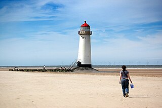
Talacre is a village in Flintshire on the north coast of Wales in the community of Llanasa and the electoral ward of Ffynnongroyw, and is the northernmost mainland settlement in Wales. The village itself has a population of 347 as of the 2011 census.

Abermorddu is a village in the county of Flintshire, Wales, in the community of Hope. Approximately 5 miles north of Wrexham along the A541 road, it is contiguous with the main village of Caergwrle and closely related to the village of Hope. In the 19th century there was a turnpike road known as Abermorddu Branch running from the tollhouse at King's Ferry to Abermorddu.

Mynydd Isa is a village in Flintshire, in north-east Wales. It lies between the county town of Mold, and Buckley in the community of Argoed which had a population of 5837 according to the 2011 census. Mynydd Isa was originally a small hamlet on the north side of the Mold to Buckley road just downhill from the now demolished Calvinist chapel. It did not appear on Ordnance Survey maps until 1912.

Sealand is a community in Flintshire and electoral ward, north-east Wales, on the edge of the Wirral peninsula. It is west of the city of Chester, England, and is part of the Deeside conurbation on the Wales-England border. At the 2001 Census, it had a population of 2,746, increasing to 2,996 at the 2011 census. The community includes the villages of Garden City and Sealand, and the settlements of Higher Ferry, Sealand Manor and Sealand Road.

New York State Route 52 (NY 52) is a 108.72-mile-long (174.97 km) state highway in the southeastern part of the state. It generally runs from west to east through five counties, beginning at the Pennsylvania state line in the Delaware River near Narrowsburg, crossing the Hudson River on the Newburgh–Beacon Bridge, and ending in Carmel. NY 52 and NY 55, both major east–west routes of the Mid-Hudson Region, run parallel to each other, intersecting in downtown Liberty.

Sychdyn or Soughton is a village in Flintshire, Wales. It is situated on the A5119 road, and is just over 1000 yards (1 km) north of the county town of Mold.

Treuddyn is a village, community and electoral ward in Flintshire, Wales, located just off the A5104 road, around 4 miles south-east of Mold and 3 miles north-west of Caergwrle. The community includes the nearby village of Coed Talon, to the east, and Rhydtalog, to the south-west on the Denbighshire border.
Brynford is a village and community in Flintshire, Wales. It is located to the south west of the town of Holywell and near the A55 road. Brynford had a population of 1,059 at the 2011 census.

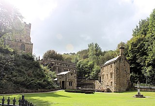
Pantasaph is a small village in Flintshire, north-east Wales, two miles south of Holywell in the community of Whitford. Its name translates into English as Asaph's Hollow.
Whitford is a village, community and an electoral ward near Holywell in Flintshire, northeast Wales. The population of both the community and the ward taken at the 2011 census was 2,332. The community includes the villages of Carmel, Lloc, Gorsedd and Pantasaph.

Cymau is a small village situated in the community of Llanfynydd, Flintshire on the edge of the mountains of north-east Wales. Its name is the Welsh word cymau, a plural of cwm, "valley".

Bretton is a village in Flintshire, Wales. It is located to the west of the city of Chester, near the border with Cheshire, England. Along with the nearby village of Broughton, the population was 5,791 at the 2001 Census.

Azzana is a commune in the Corse-du-Sud department on the island of Corsica, France.

Alltami is a small village in Flintshire, in northeast Wales northwest of Buckley and northeast of Mold. It lies on the A494 road which runs from Ellesmere Port to Dolgellau. There is a stream running through the village, Alltami Brook. There is a crossroads at Alltami with traffic lights; they were proposed to be installed in February 1981.

Llanfynydd is a village, local government community and electoral ward in Flintshire, Wales. Its name is derived from the Welsh words llan, and mynydd ("mountain").

Gwespyr is a village in Flintshire on the north coast of Wales in the community of Llanasa. Gwespyr had a population of 289 people in the United Kingdom 2001 census. It overlooks Point of Ayr on the west side of the River Dee estuary and its sandy beaches with dunes. The hills of the Clwydian Range behind the village form the eastern boundary of the Vale of Clwyd. Gwespyr also looks respectively Welsh but is an alien name. It represents Old English for 'West-bury' which came to be interpreted as the 'west fort' meaning the westernmost fort in Mercia. Originally, it is thought to have been a strategic Mercian lookout which was reduced in importance with the development of a fortified Rhuddlan.

