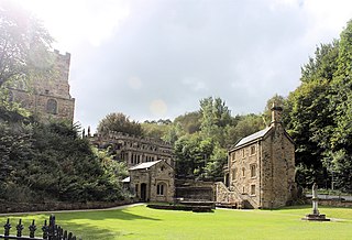
Holywell is a market town and community in Flintshire, Wales. It lies to the west of the estuary of the River Dee. The community includes Greenfield.

Mostyn is a village and community in Flintshire, Wales, and electoral ward lying on the estuary of the River Dee, located near the town of Holywell. It has a privately owned port that has in the past had a colliery and ironworks and was involved in the export of commodities, and in present times services the offshore wind industry and ships the wings for the Airbus A380 which are manufactured at Broughton.

Aberffraw is a village and community on the south west coast of the Isle of Anglesey, in Wales, by the west bank of the Afon Ffraw. The community includes Soar and Dothan. Located near the A4080 and the nearest rail station is Bodorgan.
Pentraeth is a village and community on the island of Anglesey, North Wales, at grid reference SH523786. The Royal Mail postcode begins LL75. The community population taken at the 2011 census was 1,178. The village itself having a population of 557.

Overton or Overton-on-Dee is a village and community in Wrexham County Borough, Wales. It is situated close to the Welsh-English border on the edge of an escarpment that winds its way around the course of the River Dee, from which Overton-on-Dee derives its name.

Ewloe is a village and electoral ward in the community of Hawarden in Flintshire, Wales. It is situated close to the Flintshire/Cheshire sector of the Wales-England border. The A55 expressway passes through Ewloe and its most notable landmark is Ewloe Castle. The Ewloe electoral ward had a population at the 2011 Census of 5,420. The urban area of the village is contiguous with Hawarden, Buckley and Shotton. The Office for National Statistics deems Ewloe to form part of the Buckley built-up area, which covers much of Deeside.

Caerwys is a town in Flintshire, Wales. It is just under two miles from the A55 North Wales Expressway and one mile from the A541 Mold-Denbigh road. At the 2001 Census, the population of Caerwys community was 1,315, with a total ward population of 2,496. Following reorganisation the community population fell at the 2011 Census to 1,283 with the ward raising to 2,569. The community includes Afonwen.
Bagillt is a market town and community in Flintshire, Wales. The town overlooks the Dee Estuary and is between the towns of Holywell and Flint. At the 2001 Census the population was recorded as 3,918, increasing to 4,165 at the 2011 census. The community also includes the villages of Walwen and Whelston. Landmark locations such as Gemma Rushes bath.

Northop is a village, community and electoral ward situated in Flintshire, Wales, approximately 12 miles west of the city of Chester, midway between Mold and Flint, and situated just off junction 33 of the A55 North Wales Expressway. At the 2001 Census, the population of Northop was 2,983, increasing to 3,049 at the 2011 census. The community includes Sychdyn.

Clynnog Fawr, often simply called "Clynnog", is a village and community on the north coast of Llŷn Peninsula in Gwynedd, north-west Wales. It is in the historic county of Caernarfonshire. The community includes Pant Glas.

Higher Kinnerton is a village and community within rural Flintshire, Wales, close to the Wales-England border. Its sister village, Lower Kinnerton, is across the border in Cheshire, England.

Treuddyn is a village, community and electoral ward in Flintshire, Wales, located just off the A5104 road, around 4 miles south-east of Mold and 3 miles north-west of Caergwrle. The community includes the nearby village of Coed Talon, to the east, and Rhydtalog, to the south-west on the Denbighshire border.

Nannerch is a village and community in Flintshire, Wales, located within the Clwydian Range and Dee Valley Area of Outstanding Natural Beauty. At the 2001 Census the population of Nannerch was 531, reducing to 496 in 2011.
Halkyn is a village and community in Flintshire, north-east Wales and situated between Pentre Halkyn, Northop and Rhosesmor. At the 2001 Census the population of the community was 2,876, increasing slightly to 2,879 at the 2011 Census. Pentre Halkyn is in the community.

Burton is a small village, parish and community in Pembrokeshire, Wales, set on a hill overlooking the River Cleddau with views of the estuary to the south, east and west. The community includes the village of Hill Mountain.
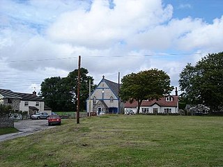
Brynford is a village and community in Flintshire, Wales. It is located to the south west of the town of Holywell and near the A55 road. Brynford had a population of 1,059 at the 2011 census.

Dodleston is a village and civil parish in the unitary authority of Cheshire West and Chester and the ceremonial county of Cheshire, England. The village is situated to the south west of Chester, very close to the England–Wales border. The civil parish includes Balderton, Gorstella, Lower Kinnerton and Rough Hill. It is one of the three old Cheshire parishes which are situated on the Flintshire side of the River Dee.
Llanaelhaearn is a village and community on the Llŷn Peninsula in the county of Gwynedd, Wales. The community includes the larger village of Trefor and has a population of 1,067, increasing to 1,117 at the 2011 Census.

Llanfynydd is a village, local government community and electoral ward in Flintshire, Wales. Its name is derived from the Welsh words llan, and mynydd ("mountain").

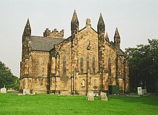
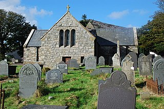
The Church of St Beuno and St Mary is a Grade I listed church in Whitford, overlooking the estuary of the river Dee. The church has a well preserved late medieval


