
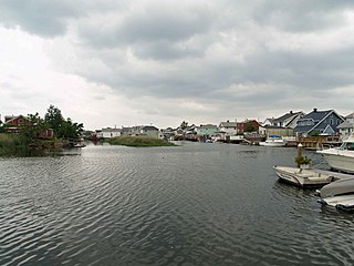
Coney Island is a peninsular neighborhood and entertainment area in the southwestern section of the New York City borough of Brooklyn. The neighborhood is bounded by Brighton Beach and Manhattan Beach to its east, Lower New York Bay to the south and west, and Gravesend to the north and includes the subsection of Sea Gate on its west. More broadly, Coney Island or sometimes for clarity the Coney Island peninsula consists of Coney Island proper, Brighton Beach, and Manhattan Beach. This was formerly the westernmost of the Outer Barrier islands on the southern shore of Long Island, but in the early 20th century it became a peninsula, connected to the rest of Long Island by land fill.

The Rockaway Park Shuttle is a New York City Subway shuttle train that operates in Queens. It connects with the A train at Broad Channel station and is the latest iteration of the Rockaway Shuttle services that have been running on the Rockaway peninsula since 1956. This shuttle train provides service to the western part of the peninsula, with a terminus at Rockaway Park–Beach 116th Street. The fully above-ground route operates on trackage that was originally part of the Long Island Rail Road's Far Rockaway Branch until the mid-1950s. During summer weekends, to eliminate an additional transfer and thus ease beach access, the Rockaway Park Shuttle is typically extended four stations north to Rockaway Boulevard, the southernmost station shared by Rockaway-bound and Lefferts Boulevard-bound A trains.

The Rockaway Peninsula, commonly referred to as The Rockaways or Rockaway, is a peninsula at the southern edge of the New York City borough of Queens on Long Island, New York. Relatively isolated from Manhattan and other more urban parts of the city, Rockaway became a popular summer retreat in the 1830s. It has since become a mixture of lower, middle, and upper-class neighborhoods. In the 2010s, it became one of the city's most quickly gentrifying areas.
Howard Beach is a neighborhood in the southwestern portion of the New York City borough of Queens. It is bordered to the north by the Belt Parkway and Conduit Avenue in Ozone Park, to the south by Jamaica Bay in Broad Channel, to the east by 102nd–104th Streets in South Ozone Park, and to the west by 75th Street in East New York, Brooklyn. The area consists mostly of low-rise single-family houses.

Broad Channel is a neighborhood in the southern portion of the New York City borough of Queens. It occupies the southern portion of Rulers Bar Hassock, the only inhabited island in Jamaica Bay.

Rockaway Beach is a neighborhood on the Rockaway Peninsula in the New York City borough of Queens. The neighborhood is bounded by Arverne to the east and Rockaway Park to the west. It is named for the Rockaway Beach and Boardwalk, which is the largest urban beach in the United States, stretching from Beach 3rd to Beach 153rd Streets on the Atlantic Ocean. The neighborhood, with 13,000 residents as of 2010, is also known as the "Irish Riviera" because of its large Irish American population.
Belle Harbor is a small residential neighborhood in the New York City borough of Queens, located on the western half of the Rockaway Peninsula, the southernmost area of the borough. Belle Harbor commonly refers to the area from Beach 126th to Beach 141st Streets.

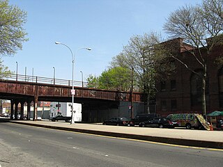
The Grant Avenue station is a station on the IND Liberty Av Line of the New York City Subway. Located at Grant Avenue just north of Pitkin Avenue in City Line, Brooklyn, near the border between the boroughs of Brooklyn and Queens, it is served by the A train at all times. The station is the line's easternmost stop in Brooklyn; the Fulton Street Line continues east into Queens via the Fulton Street Elevated.

The Rockaway Park–Beach 116th Street station is the western terminal station on the IND Rockaway Line of the New York City Subway, located on Beach 116th Street near Rockaway Beach Boulevard in Rockaway Beach, Queens. It is served by the Rockaway Park Shuttle at all times and ten daily rush-hour A trains in the peak direction.

Rockaway Park is a neighborhood in the New York City borough of Queens. The area is on the Rockaway Peninsula, nestled between Jamaica Bay to the north and the Atlantic Ocean to the south. The neighborhood of Rockaway Beach lies on its eastern border while the community of Belle Harbor is situated on its western side. The neighborhood is part of Queens Community Board 14.

Jacob Riis Park, also called Jacob A. Riis Park and Riis Park, is a seaside park on the southwestern portion of the Rockaway Peninsula in the New York City borough of Queens. It lies at the foot of the Marine Parkway–Gil Hodges Memorial Bridge, east of Fort Tilden, and west of Neponsit and Rockaway Beach. Originally run by the New York City Department of Parks and Recreation, it is now part of the Jamaica Bay Unit of the Gateway National Recreation Area, and is managed by the National Park Service (NPS). It features an extensive sand beach along the Atlantic Ocean coastline and several historic Art Deco structures.

Shore Front Parkway is a 2.5-mile (4.0 km) beachfront road paralleling the Rockaway Beach and Boardwalk in the New York City borough of Queens, running between Beach 73rd Street and Beach 108th Street.
Rockaways' Playland was an amusement park that operated from 1902 to 1987 in Rockaway Beach in Queens, New York City. Bounded by Beach 97th and Beach 98th Streets between Rockaway Beach Boulevard and the Rockaway Beach and Boardwalk, Rockaways' Playland was created in 1902 by roller coaster designer LaMarcus Adna Thompson. By 1903 a ferry dock was added not far from the park, making it more convenient to reach than some of the competing amusement parks. The park was sold in 1927 to Robert Katlin who added amenities such as a gym and swimming pool, and the following year to A. Joseph Geist who achieved greater success than the previous owners. Between 1928 and 1970, Rockaways' Playland was extremely successful, drawing 175 million visitors. It closed in 1987 due to a sharp increase in the price of insurance.
The Rockaway Beach Branch was a rail line owned and operated by the Long Island Rail Road in Queens, New York City, United States. The line left the Main Line at Whitepot Junction in Rego Park heading south via Ozone Park and across Jamaica Bay to Hammels in the Rockaways, turning west there to a terminal at Rockaway Park. Along the way it connected with the Montauk Branch near Glendale, the Atlantic Branch near Woodhaven, and the Far Rockaway Branch at Hammels.

The Riegelmann Boardwalk is a 2.7-mile-long (4.3 km) boardwalk along the southern shore of the Coney Island peninsula in the New York City borough of Brooklyn, facing the Atlantic Ocean. Opened in 1923, the boardwalk runs between West 37th Street at the edge of the Sea Gate neighborhood to the west and Brighton 15th Street in Brighton Beach to the east. It is operated by the New York City Department of Parks and Recreation.

The South Beach–Franklin Delano Roosevelt Boardwalk, alternately referred to as the FDR Boardwalk or the South Beach Boardwalk, is a boardwalk facing the Lower New York Bay on the East Shore of Staten Island, one of the five boroughs of New York City. The boardwalk is the main feature of a public park that stretches from Fort Wadsworth and the Verrazzano-Narrows Bridge to Miller Field, both part of the Gateway National Recreation Area. The park also contains numerous recreational facilities, including a skate park.
Edgemere Landfill is a former municipal landfill located in Edgemere on the Rockaway peninsula in Queens, New York City. It is located on a man-made peninsula on the Jamaica Bay shoreline, at the eastern end of the Rockaway peninsula. A portion of the site is currently open to the public as Rockaway Community Park. The entire site is owned by the New York City Department of Parks and Recreation.

Far Rockaway Skate Park is a public skate park on the Rockaway Beach and Boardwalk in Far Rockaway, Queens, New York City, opened in 2011. The park is open dawn till dusk and is unsupervised. In addition to skateboarding, scooters and inline skates are permitted. The park was built over a large parking lot that was reduced in size but not eliminated. The skatepark project was part of a larger renovation of O'Donohue Park that began in 2010 and was completed in 2011. The park was designed by SITE Design Group and built by California Skateparks.

The Rockaway Beach and Boardwalk is a public park in Rockaway, Queens, New York, composed of the 170-acre (69 ha) Rockaway Beach and the adjacent 5.5-mile (8.9 km) Rockaway Boardwalk. The beach runs from Beach 9th Street in Far Rockaway to Beach 149th Street in Neponsit, a distance of 7 miles (11 km). The boardwalk, a concrete deck, runs from Beach 9th Street to Beach 126th Street in Rockaway Park, at the edge of Belle Harbor. There are also numerous recreational facilities within the park, parallel to the beach and boardwalk.
