Olive, New York

Last updated

Olive
Ulster County New York incorporated and unincorporated areas Olive highlighted.svg
Location in Ulster County and the state of New York.
Coordinates: 41°57′N74°15′W / 41.950°N 74.250°W / 41.950; -74.250
Country United States
State New York
County Ulster
Area
[1]
  Total65.19 sq mi (168.85 km2)
  Land58.45 sq mi (151.38 km2)
  Water6.74 sq mi (17.47 km2)
Elevation
705 ft (215 m)
Population
 (2020) [2]
  Total4,226
  Density65/sq mi (25/km2)
Time zone UTC-5 (Eastern (EST))
  Summer (DST) UTC-4 (EDT)
ZIP code
12461
Area code 845
FIPS code 36-54749
GNIS feature ID0979307
Website Town website

Olive is a town in Ulster County, New York, United States. The town is west of Kingston, New York, and is inside the Catskill Park. The population was 4,226 at the 2020 census. [3]

Contents

History

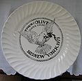
The town was settled circa 1740. The town of Olive was established in 1823 from parts of the towns of Hurley, Marbletown, and Shandaken. A limited edition 1973 commemorative plate, shown below, includes this text on the back:

The town of Olive, Ulster County, New York, was taken from Shandaken, Marbletown, and Hurley and erected by law on April 15, 1823. At that time a name was suggested for the new town by quoting the following verse from the Bible: 'and Noah sent out a Dove from the Ark and when the waters subsided she returned with an Olive leaf in her mouth.' 'Let us call it the Town of Olive.' The first town meeting was held on the second Tuesday in May 1824. The seal was adopted by the Olive Town Board on November 9, 1971. It was suggested by the Town Historian, Vera Sickler, and designed and executed by Mrs. Tisanne Gardner of Boiceville, N.Y.

front (symbol)back (history)

The creation of the Ashokan Reservoir in 1917 covered some of the communities of Olive. The reservoir is owned by New York City and is part of the city's water system.

Geography

According to the United States Census Bureau, the town has a total area of 65.1 square miles (169 km2), of which 58.7 square miles (152 km2) is land and 6.5 square miles (17 km2) (9.93%) is water.

Demographics

Historical population
CensusPop.Note
1830 1,636
1840 2,02323.7%
1850 2,71034.0%
1860 3,26220.4%
1870 3,083−5.5%
1880 2,927−5.1%
1890 2,649−9.5%
1900 2,465−6.9%
1910 4,49782.4%
1920 1,237−72.5%
1930 1,196−3.3%
1940 1,32010.4%
1950 1,46310.8%
1960 1,99936.6%
1970 2,85742.9%
1980 3,92437.3%
1990 4,0864.1%
2000 4,57912.1%
2010 4,419−3.5%
2020 4,226−4.4%
U.S. Decennial Census [4] 2020 [5]

As of the census [6] of 2000, there were 4,579 people, 1,869 households, and 1,263 families residing in the town. The population density was 78 people per square mile (30.1/km2). There were 2,306 housing units at an average density of 39.3 per square mile (15.2/km2). The racial makeup of the town was 96.68% white, .61% African American, .17% Native American, .92% Asian, .17% Pacific Islander, .48% from other races, and 0.96% from two or more races. Hispanic or Latino of any race were 2.51% of the population.

There were 1,869 households, out of which 29.8% had children under the age of 18 living with them, 55.4% were married couples living together, 7.9% had a female householder with no husband present, and 32.4% were non-families. 24.5% of all households were made up of individuals, and 8.5% had someone living alone who was 65 years of age or older. The average household size was 2.43 and the average family size was 2.91.

In the town, the population was spread out, with 24.2% under the age of 18, 4.6% from 18 to 24, 26.6% from 25 to 44, 31.1% from 45 to 64, and 13.6% who were 65 years of age or older. The median age was 42 years. For every 100 females, there were 99.1 males. For every 100 females age 18 and over, there were 96.0 males.

The median income for a household in the town was $45,409, and the median income for a family was $50,931. Males had a median income of $33,125 versus $27,008 for females. The per capita income for the town was $21,569. About 3.5% of families and 5.0% of the population were below the poverty line, including 4.6% of those under age 18 and 3.6% of those age 65 or over.

Communities and locations in Olive

The Nine Hamlets are: [7]

Other locations

See also

Related Research Articles

<span class="mw-page-title-main">Westerlo, New York</span> Town in New York, United States

Westerlo is a town in Albany County, New York, United States. The population was 3,194 at the 2020 census.

Harpersfield is a town in Delaware County, New York, United States. The population was 1,442 at the 2020 census. The town is on the northern border of the county.

Meredith is a town in Delaware County, New York, United States. The population was 1,484 at the 2020 census. It is an interior town in the northern part of the county.

<span class="mw-page-title-main">Tompkins, New York</span> Town in Delaware County, New York, US

Tompkins is a town in Delaware County, New York, United States. The population was 1,290 at the 2020 census. The town is named after Daniel D. Tompkins, the fourth governor of New York and sixth vice president of the United States.

<span class="mw-page-title-main">Halcott, New York</span> Town in New York, United States

Halcott is a town in Greene County, New York, United States. The population was 249 in 2020, down from 258 at the 2010 census. The town is in the southwestern corner of the county.

<span class="mw-page-title-main">Jewett, New York</span> Town in New York, United States

Jewett is a town centrally located in Greene County, New York, United States. The population was 879 at the 2020 census. The town is named for Freeborn G. Jewett, justice of the New York Supreme Court.

<span class="mw-page-title-main">Prattsville (town), New York</span> Town in New York, United States

Prattsville is a town in Greene County, New York, United States. The town is in the northwestern part of the county. As of the 2020 census, the population was 774.

<span class="mw-page-title-main">Pittstown, New York</span> Town in New York, United States

Pittstown is a town in Rensselaer County, New York, United States. The population was 5,540 at the 2020 census. It is in the northern part of the county.

<span class="mw-page-title-main">Gilboa, New York</span> Town in New York, United States

Gilboa is a town in Schoharie County, New York, United States. The population was 1,111 at the 2020 census.

<span class="mw-page-title-main">Seward, New York</span> Town in New York, United States

Seward is a town in Schoharie County, New York, United States. The population was 1,583 at the 2020 census. The town is named after senator, governor, and secretary of state William H. Seward.

<span class="mw-page-title-main">Neversink, New York</span> Town in New York, United States

Neversink is a town in Sullivan County, New York, United States. The population was 3,366 at the 2020 census.

<span class="mw-page-title-main">Denning, New York</span> Town in New York, United States

Denning is an isolated town in Ulster County, New York, United States. The population was 493 at the 2020 census. The town is named after an early landowner, William Denning. Denning is located in the western part of the county, deep inside the Catskill Mountains. The location of the town in the Catskill State Park accounts in part for its low population.

<span class="mw-page-title-main">Hardenburgh, New York</span> Town in New York, United States

Hardenburgh is a town located in the western part of Ulster County, New York, United States. The population was 221 at the 2020 census. The town is located inside the Catskill Park.

<span class="mw-page-title-main">Shandaken, New York</span> Town in New York, United States

Shandaken is a town on the northern border of Ulster County, New York, United States, northwest of Kingston, New York. As of the 2020 census, the town had a total population of 2,866. The name is believed to be from an Esopus phrase for "land of rapid waters."

<span class="mw-page-title-main">Hunter, New York</span> Town in New York, United States

Hunter is a town located in Greene County, New York, United States. The population was 3,035 at the time of the 2020 census. The town contains two villages, one named Hunter on the west, and the second called Tannersville, as well as a number of hamlets such as Haines Falls, Platte Clove, Lanesville and Edgewood. Additionally, there are three residential parks location within town limits: Onteora Park, Twilight Park and Elka Park. The town is on the southern border of Greene County and abuts the towns of Woodstock and Saugerties, located in Ulster County.

Deposit is a town in Delaware County, New York, United States. As of the 2020 census, the town's population was 1,427.

<span class="mw-page-title-main">Ashokan Reservoir</span> New York City reservoir in Catskill Mountains

The Ashokan Reservoir is a reservoir in Ulster County, New York. It is at the eastern end of the Catskill Park, and is one of several in the region created to provide the City of New York with water. It is the city's deepest reservoir at 190 feet (58 m) near the dam at the former site of Bishop Falls.

<span class="mw-page-title-main">Olivebridge, New York</span> Hamlet in New York state, United States

Olivebridge is a hamlet in the town of Olive, Ulster County, New York, United States, within Catskill Park and the Catskill Mountains.

<span class="mw-page-title-main">Plattekill, New York</span> Place in New York, United States

Plattekill is a town in Ulster County, New York, United States. The population was 10,424 in 2020, a slight decrease from 10,499 at the 2010 census. The name is derived from a stream, the Platte Kill.

<span class="mw-page-title-main">Samsonville, New York</span> Hamlet in New York, United States

Samsonville is a hamlet in the southwestern part of the town of Olive in Ulster County, New York, United States. Bordered to the north by Mombaccus Mountain and Ashokan High Point, it is within the Catskill Park on the southeastern slopes of the high Catskills.

References

  1. "2016 U.S. Gazetteer Files". United States Census Bureau. Retrieved July 5, 2017.
  2. US Census Bureau, 2020 Census, Olive town, Greene County, New York https://www.census.gov/search-results.html?searchType=web&cssp=SERP&q=Olive%20town,%20Ulster%20County,%20New%20York
  3. US Census Bureau, 2020 Census, Olive town, Greene County, New York https://www.census.gov/search-results.html?searchType=web&cssp=SERP&q=Olive%20town,%20Ulster%20County,%20New%20York
  4. "Census of Population and Housing". Census.gov. Retrieved June 4, 2015.
  5. US Census Bureau, 2020 Census, Olive town, Greene County, New York https://www.census.gov/search-results.html?searchType=web&cssp=SERP&q=Olive%20town,%20Ulster%20County,%20New%20York
  6. "U.S. Census website". United States Census Bureau . Retrieved January 31, 2008.
  7. Map of the Nine Hamlets of Olive in John Bierhorst, The Ashokan Catskills: A Natural History, Fleischmanns, New York: Purple Mountain Press, 1995, p. 4. The town of Olive website lists only seven hamlets, omitting Brodhead and Brown's Station, which are almost completely under water now. "town.olive.ny.us".
  8. "Olive historical quilt".
  9. Rosendale USGS Topographic Map, 1903.
  10. "Catskill Archive". "Catskill Archive, U&D RR".