Rensselaerville is a town in Albany County, New York, United States. The population was 1,843 at the 2010 census. The town is named after Stephen Van Rensselaer.

Grand Island is a town located in Erie County, New York, United States. As of the 2010 census, the town's population was 20,374, representing an increase of 9.41% from the 2000 census figure. The town's name derives from the French name La Grande Île, as Grand Island is the largest island in the Niagara River and third largest in New York state. The phrase La Grande Île appears on the town seal.

Prattsville is a town in Greene County, New York, United States. The town is in the northwest part of the county. As of the 2010 census, the population was 700.

Livingston Manor is a hamlet in Sullivan County, New York, United States. The population was 1,221 at the 2010 census.

Rockland is a town in the northern part of Sullivan County, New York, United States. At the 2010 census, the population was 3,775.

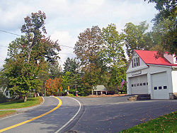
Roscoe is a hamlet in Sullivan County, New York, United States. The population was 541 at the 2010 census.

Denning is an isolated town in Ulster County, New York, USA. The population was 551 at the 2010 census. The town is named after an early landowner, William Denning. Denning is located in the western part of the county, deep inside the Catskill Mountains. The location of the town in the Catskill State Park accounts in part for its low population.

Hardenburgh is a town located in the western part of Ulster County, New York, United States. The population was 215 at the 2010 census. The town is located inside the Catskill Park.

Shandaken is a town on the northern border of Ulster County, New York, United States, northwest of Kingston, New York. As of the 2010 census, the town had a total population of 3,085. The name is believed to be from an Esopus phrase for "land of rapid waters."

Wawarsing is a town in Ulster County, New York, United States. The population was 13,157 at the 2010 census. The name means "a place where the stream bends" in the Warwarsink language and refers to the geography of the land; particularly the joining of the Ver Nooy Kill and the Rondout Creek.

The Beaver Kill, sometimes written as the Beaverkill or Beaverkill River, is a tributary of the East Branch Delaware River, a main tributary of the Delaware River, approximately 44 miles (71 km) long, in the U.S. State of New York. The kill drains a 300-square-mile (780 km2) area of the Catskill Mountains and has long been celebrated as one of the most famous trout streams in the United States. Its preservation helped establish many of the basic conservation principles of rivers in the United States.

The East Branch Delaware River is one of two branches that form the Delaware River. It is approximately 75 mi (121 km) long, and flows through the U.S. state of New York. It winds through a mountainous area on the southwestern edge of Catskill Park in the Catskill Mountains for most of its course, before joining the West Branch along the northeast border of Pennsylvania with New York. For a long stretch it serves as the Blue Line, the park's boundary. Much of it is paralleled by State Route 30.

Salem is a town in eastern Washington County, New York, United States. It is part of the Glens Falls Metropolitan Statistical Area. The town population was 2,702 at the 2000 census. The town of Salem contains a hamlet also named Salem, formerly an incorporated village.

Beaverkill Bridge, also known as Conklin Bridge, is a wooden covered bridge over the Beaver Kill north of the hamlet of Roscoe in the Town of Rockland, New York, United States, that carries Conklin Road through Beaverkill State Campground. It was erected in 1865, one of the first bridges over the river in what was then still a largely unsettled region of the Catskill Mountains.

The Grahamsville Historic District is a historic district located along both sides of NY 55 just east of that hamlet in the Town of Neversink in Sullivan County, New York, United States. Its church is across the road from Tri-Valley Central School. In 1979 it was added to the National Register of Historic Places.

Livingstonville, New York is a hamlet within the town of Broome, New York. It is inhabited by a small but decreasing population.
Mount Tremper, officially known as Tremper Mountain and originally called Timothyberg, is one of the Catskill Mountains in the U.S. state of New York. It is located near the hamlet of Phoenicia, in the valley of Esopus Creek.

The Beaverkill Valley Inn, formerly known as The Bonnie View, is located off Beaverkill Road north of Lew Beach, New York, United States. It is a large wooden hotel built near the end of the 19th century.

Catskill Creek is a 46.0-mile-long (74.0 km) tributary of the Hudson River that drains the northeastern Catskill Mountains of the U.S. State of New York. From its source at Franklinton Vlaie in Schoharie County it flows southeast through parts of Albany County and Greene County to its mouth at the village of Catskill on the Hudson River.